MOD15A2H V6.1 MODIS সম্মিলিত লিফ এরিয়া ইনডেক্স (LAI) এবং ফটোসিন্থেটিকলি অ্যাক্টিভ রেডিয়েশনের ভগ্নাংশ (FPAR) পণ্যটি 500m রেজোলিউশনে একটি 8-দিনের যৌগিক ডেটাসেট। অ্যালগরিদম 8 দিনের সময়ের মধ্যে টেরা সেন্সরের সমস্ত অধিগ্রহণ থেকে উপলব্ধ "সেরা" পিক্সেল বেছে নেয়।
[null,null,[],[[["\u003cp\u003eMOD15A2H V6.1 provides an 8-day composite of Leaf Area Index (LAI) and Fraction of Photosynthetically Active Radiation (FPAR) data at 500m resolution.\u003c/p\u003e\n"],["\u003cp\u003eThe dataset is derived from the Terra sensor and the algorithm selects the best pixel from acquisitions within the 8-day period.\u003c/p\u003e\n"],["\u003cp\u003eIt includes bands for LAI, FPAR, quality control, and standard deviation, offering comprehensive vegetation information.\u003c/p\u003e\n"],["\u003cp\u003eMODIS data and products acquired through the LP DAAC have no restrictions on subsequent use, sale, or redistribution.\u003c/p\u003e\n"],["\u003cp\u003eThe dataset is available from February 18, 2000 to November 24, 2024 and can be explored using Google Earth Engine.\u003c/p\u003e\n"]]],["The MOD15A2H V6.1 dataset provides 8-day composite data on Leaf Area Index (LAI) and Fraction of Photosynthetically Active Radiation (FPAR) at 500m resolution, using the Terra sensor. Data spans from 2000-02-18 to 2025-02-10. Key bands include 'Lai_500m' and 'Fpar_500m', with associated quality control and standard deviation metrics. The dataset, provided by NASA LP DAAC, is freely available for use, sale, or redistribution. Access is provided through Google Earth Engine.\n"],null,["# MOD15A2H.061: Terra Leaf Area Index/FPAR 8-Day Global 500m\n\nDataset Availability\n: 2000-02-18T00:00:00Z--2025-08-13T00:00:00Z\n\nDataset Provider\n:\n\n\n [NASA LP DAAC at the USGS EROS Center](https://doi.org/10.5067/MODIS/MOD15A2H.061)\n\nCadence\n: 8 Days\n\nTags\n:\n [8-day](/earth-engine/datasets/tags/8-day) [fpar](/earth-engine/datasets/tags/fpar) [global](/earth-engine/datasets/tags/global) [lai](/earth-engine/datasets/tags/lai) [modis](/earth-engine/datasets/tags/modis) [nasa](/earth-engine/datasets/tags/nasa) [plant-productivity](/earth-engine/datasets/tags/plant-productivity) [terra](/earth-engine/datasets/tags/terra) [usgs](/earth-engine/datasets/tags/usgs) \nmod15a2h \n\n#### Description\n\nThe MOD15A2H V6.1 MODIS combined Leaf Area Index (LAI) and\nFraction of Photosynthetically Active Radiation (FPAR) product is an 8-day\ncomposite dataset at 500m resolution. The algorithm chooses the \"best\" pixel\navailable from all the acquisitions of the Terra sensor from within the 8-day period.\n\nDocumentation:\n\n- [User's Guide](https://lpdaac.usgs.gov/documents/624/MOD15_User_Guide_V6.pdf)\n\n- [Algorithm Theoretical Basis Document (ATBD)](https://lpdaac.usgs.gov/documents/90/MOD15_ATBD.pdf)\n\n- [General Documentation](https://ladsweb.modaps.eosdis.nasa.gov/filespec/MODIS/61/MOD15A2H)\n\n### Bands\n\n\n**Pixel Size**\n\n500 meters\n\n**Bands**\n\n| Name | Units | Min | Max | Scale | Pixel Size | Description |\n|-------------------|---------------|-----|-----|-------|------------|-------------------------------------------------|\n| `Fpar_500m` | % | 0 | 100 | 0.01 | meters | Fraction of Photosynthetically Active Radiation |\n| `Lai_500m` | Area fraction | 0 | 100 | 0.1 | meters | Leaf Area Index |\n| `FparLai_QC` | | 0 | 254 | | meters | Quality for LAI and FPAR |\n| `FparExtra_QC` | | 0 | 254 | | meters | Extra detail Quality for LAI and FPAR |\n| `FparStdDev_500m` | % | 0 | 100 | 0.01 | meters | Standard deviation of FPAR |\n| `LaiStdDev_500m` | Area fraction | 0 | 100 | 0.1 | meters | Standard deviation of LAI |\n\n### Terms of Use\n\n**Terms of Use**\n\nMODIS data and products acquired through the LP DAAC\nhave no restrictions on subsequent use, sale, or redistribution.\n\n### Citations\n\nCitations:\n\n- Please visit [LP DAAC 'Citing Our Data' page](https://lpdaac.usgs.gov/citing_our_data)\n for information on citing LP DAAC datasets.\n\n### DOIs\n\n- \u003chttps://doi.org/10.5067/MODIS/MOD15A2H.061\u003e\n\n### Explore with Earth Engine\n\n| **Important:** Earth Engine is a platform for petabyte-scale scientific analysis and visualization of geospatial datasets, both for public benefit and for business and government users. Earth Engine is free to use for research, education, and nonprofit use. To get started, please [register for Earth Engine access.](https://console.cloud.google.com/earth-engine)\n\n### Code Editor (JavaScript)\n\n```javascript\n
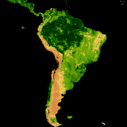
var collection = ee.ImageCollection('MODIS/061/MOD15A2H')\n .filterDate('2019-01-01', '2019-10-01');\n\nvar colorizedVis = {\n min: 0,\n max: 100,\n palette: [\n 'ffffff', 'ce7e45', 'df923d', 'f1b555', 'fcd163', '99b718', '74a901',\n '66a000', '529400', '3e8601', '207401', '056201', '004c00', '023b01',\n '012e01', '011d01', '011301'\n ],\n};\n\nMap.setCenter(-10.88, 40.94, 2);\nMap.addLayer(collection.select('Lai_500m'), colorizedVis, 'Lai');\nMap.addLayer(collection.select('Fpar_500m'), colorizedVis, 'Fpar');\n```\n[Open in Code Editor](https://code.earthengine.google.com/?scriptPath=Examples:Datasets/MODIS/MODIS_061_MOD15A2H) \n[MOD15A2H.061: Terra Leaf Area Index/FPAR 8-Day Global 500m](/earth-engine/datasets/catalog/MODIS_061_MOD15A2H) \nThe MOD15A2H V6.1 MODIS combined Leaf Area Index (LAI) and Fraction of Photosynthetically Active Radiation (FPAR) product is an 8-day composite dataset at 500m resolution. The algorithm chooses the \"best\" pixel available from all the acquisitions of the Terra sensor from within the 8-day period. Documentation: User's Guide Algorithm Theoretical ... \nMODIS/061/MOD15A2H, 8-day,fpar,global,lai,modis,nasa,plant-productivity,terra,usgs \n2000-02-18T00:00:00Z/2025-08-13T00:00:00Z \n-90 -180 90 180 \nGoogle Earth Engine \nhttps://developers.google.com/earth-engine/datasets\n\n- [https://doi.org/10.5067/MODIS/MOD15A2H.061](https://doi.org/https://doi.org/10.5067/MODIS/MOD15A2H.061)\n- [https://doi.org/10.5067/MODIS/MOD15A2H.061](https://doi.org/https://developers.google.com/earth-engine/datasets/catalog/MODIS_061_MOD15A2H)"]]