- Disponibilidad del conjunto de datos
- 2002-07-04T00:00:00Z–2025-12-11T00:00:00Z
- Proveedor del conjunto de datos
- NASA LP DAAC at the USGS EROS Center
- Cadencia
- 16 días
- Etiquetas
Descripción
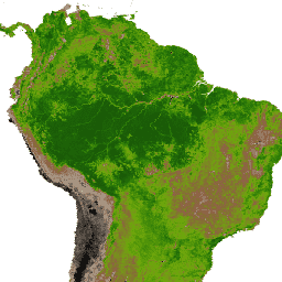
El producto MYD13Q1 V6.1 proporciona un valor del índice de vegetación (VI) para cada píxel. Hay dos capas de vegetación principales. El primero es el Índice de Vegetación de Diferencia Normalizada (NDVI), que se conoce como el índice de continuidad del NDVI existente derivado del Radiómetro Avanzado de Muy Alta Resolución (AVHRR) de la Administración Nacional Oceánica y Atmosférica (NOAA). La segunda capa de vegetación es el Índice de vegetación mejorado (EVI), que minimiza las variaciones del fondo de la cobertura arbórea y mantiene la sensibilidad en condiciones de vegetación densa. El EVI también usa la banda azul para quitar la contaminación atmosférica residual causada por el humo y las nubes delgadas de subpíxeles. Los productos de NDVI y EVI de MODIS se calculan a partir de reflectancias bidireccionales de la superficie corregidas atmosféricamente que se enmascararon para el agua, las nubes, los aerosoles pesados y las sombras de las nubes.
Documentación:
Bandas
Tamaño de los píxeles
250 metros
Bandas
| Nombre | Unidades | Mín. | Máx. | Escala | Tamaño de los píxeles | Longitud de onda | Descripción | ||||||||||||||||||||||||||||||||||||||||||||||||||||||||||||||||||||||||||||||||||||||||||||
|---|---|---|---|---|---|---|---|---|---|---|---|---|---|---|---|---|---|---|---|---|---|---|---|---|---|---|---|---|---|---|---|---|---|---|---|---|---|---|---|---|---|---|---|---|---|---|---|---|---|---|---|---|---|---|---|---|---|---|---|---|---|---|---|---|---|---|---|---|---|---|---|---|---|---|---|---|---|---|---|---|---|---|---|---|---|---|---|---|---|---|---|---|---|---|---|---|---|---|---|
NDVI |
-2000 | 10000 | 0.0001 | metros | Ninguna | Índice de vegetación de diferencia normalizada |
|||||||||||||||||||||||||||||||||||||||||||||||||||||||||||||||||||||||||||||||||||||||||||||
EVI |
-2000 | 10000 | 0.0001 | metros | Ninguna | Índice de vegetación mejorado |
|||||||||||||||||||||||||||||||||||||||||||||||||||||||||||||||||||||||||||||||||||||||||||||
DetailedQA |
metros | Ninguna | Indicadores de calidad de VI |
||||||||||||||||||||||||||||||||||||||||||||||||||||||||||||||||||||||||||||||||||||||||||||||||
sur_refl_b01 |
0 | 10,000 | 0.0001 | metros | 645 nm | Reflectancia de la superficie en el rojo |
|||||||||||||||||||||||||||||||||||||||||||||||||||||||||||||||||||||||||||||||||||||||||||||
sur_refl_b02 |
0 | 10,000 | 0.0001 | metros | 858 nm | Reflectancia de la superficie en el NIR |
|||||||||||||||||||||||||||||||||||||||||||||||||||||||||||||||||||||||||||||||||||||||||||||
sur_refl_b03 |
0 | 10,000 | 0.0001 | metros | 469 nm | Reflectancia de la superficie en azul |
|||||||||||||||||||||||||||||||||||||||||||||||||||||||||||||||||||||||||||||||||||||||||||||
sur_refl_b07 |
0 | 10,000 | 0.0001 | metros | 2130 nm/2105 a 2155 nm | Reflectancia de la superficie del MIR |
|||||||||||||||||||||||||||||||||||||||||||||||||||||||||||||||||||||||||||||||||||||||||||||
ViewZenith |
º | 0 | 18,000 | 0.01 | metros | Ninguna | Ángulo cenital de visualización |
||||||||||||||||||||||||||||||||||||||||||||||||||||||||||||||||||||||||||||||||||||||||||||
SolarZenith |
º | 0 | 18,000 | 0.01 | metros | Ninguna | Ángulo cenital solar |
||||||||||||||||||||||||||||||||||||||||||||||||||||||||||||||||||||||||||||||||||||||||||||
RelativeAzimuth |
º | -18,000 | 18,000 | 0.01 | metros | Ninguna | Ángulo de acimut relativo |
||||||||||||||||||||||||||||||||||||||||||||||||||||||||||||||||||||||||||||||||||||||||||||
DayOfYear |
1 | 366 | metros | Ninguna | Día juliano del año |
||||||||||||||||||||||||||||||||||||||||||||||||||||||||||||||||||||||||||||||||||||||||||||||
SummaryQA |
metros | Ninguna | Confiabilidad de la calidad del píxel de VI |
||||||||||||||||||||||||||||||||||||||||||||||||||||||||||||||||||||||||||||||||||||||||||||||||
Condiciones de Uso
Condiciones de Uso
Los datos y productos de MODIS que se obtuvieron mediante el LP DAAC no tienen restricciones sobre su uso, venta o redistribución posteriores.
Citas
Visita la página sobre citas de nuestros datos del LP DAAC para obtener información sobre cómo hacer mención de los conjuntos de datos.
DOI
Explora con Earth Engine
Editor de código (JavaScript)
var dataset = ee.ImageCollection('MODIS/061/MYD13Q1')
                  .filter(ee.Filter.date('2018-01-01', '2018-05-01'));
var ndvi = dataset.select('NDVI');
var ndviVis = {
  min: 0,
  max: 8000,
  palette: [
    'ffffff', 'ce7e45', 'df923d', 'f1b555', 'fcd163', '99b718', '74a901',
    '66a000', '529400', '3e8601', '207401', '056201', '004c00', '023b01',
    '012e01', '011d01', '011301'
  ],
};
Map.setCenter(6.746, 46.529, 2);
Map.addLayer(ndvi, ndviVis, 'NDVI');