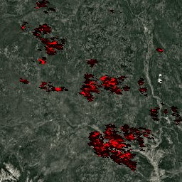
MYD14A1 V6.1 데이터 세트는 MODIS 4마이크로미터 및 11마이크로미터 복사휘도에서 파생된 1km 해상도의 일일 화재 마스크 컴포지트를 제공합니다.
화재 감지 전략은 화재의 절대 감지 (화재 강도가 감지할 수 있을 만큼 충분한 경우)와 배경에 대한 상대적 감지 (표면 온도와 햇빛에 의한 반사의 변동성을 고려)를 기반으로 합니다. 제품은 화재, 화재 없음, 관찰 없음 간에 차이를 구분합니다. 이 정보는 다양한 생태계에서 화재의 공간적 및 시간적 분포를 모니터링하고, 화재 분포의 변화를 감지하고, 새로운 화재 발생 지역, 산불, 화재 빈도 또는 상대적 강도의 변화를 식별하는 데 사용됩니다.
[null,null,[],[[["\u003cp\u003eThe MYD14A1 V6.1 dataset provides daily global fire mask composites at 1km resolution, distinguishing between fire, no fire, and no observation.\u003c/p\u003e\n"],["\u003cp\u003eThis dataset, derived from MODIS, uses a fire detection strategy based on absolute and relative fire strength detection for accurate identification.\u003c/p\u003e\n"],["\u003cp\u003eIt's used to monitor fire distribution, detect changes, and identify new fire frontiers, wildfires, and frequency changes.\u003c/p\u003e\n"],["\u003cp\u003eThe data is freely available for use, sale, or redistribution with proper citation to the LP DAAC.\u003c/p\u003e\n"],["\u003cp\u003eUsers can explore the dataset using Earth Engine, a platform for scientific analysis and visualization of geospatial datasets.\u003c/p\u003e\n"]]],["The MYD14A1 V6.1 dataset offers daily 1km resolution fire mask composites from MODIS radiances, available from July 4, 2002, to February 17, 2025. Fire detection is based on absolute fire strength and relative background detection. The dataset distinguishes between fire, no fire, and no observation, aiding in monitoring fire distribution and changes. Key data includes fire confidence, maximum fire radiative power, and quality indicators. It can be accessed via Google Earth Engine, using the code `ee.ImageCollection(\"MODIS/061/MYD14A1\")` and is provided by NASA LP DAAC.\n"],null,["# MYD14A1.061: Aqua Thermal Anomalies & Fire Daily Global 1km\n\nDataset Availability\n: 2002-07-04T00:00:00Z--2025-08-20T00:00:00Z\n\nDataset Provider\n:\n\n\n [NASA LP DAAC at the USGS EROS Center](https://doi.org/10.5067/MODIS/MYD14A1.061)\n\nCadence\n: 1 Day\n\nTags\n:\n [aqua](/earth-engine/datasets/tags/aqua) [daily](/earth-engine/datasets/tags/daily) [fire](/earth-engine/datasets/tags/fire) [global](/earth-engine/datasets/tags/global) [modis](/earth-engine/datasets/tags/modis) [nasa](/earth-engine/datasets/tags/nasa) [usgs](/earth-engine/datasets/tags/usgs) \nmyd14a1 \n\n#### Description\n\nThe MYD14A1 V6.1 dataset provides daily fire mask composites\nat 1km resolution derived from the MODIS 4- and 11-micrometer radiances.\nThe fire detection strategy is based on absolute detection of a\nfire (when the fire strength is sufficient to detect), and on detection\nrelative to its background (to account for variability of the surface\ntemperature and reflection by sunlight). The product distinguishes\nbetween fire, no fire and no observation. This information is used\nfor monitoring the spatial and temporal distribution of fires in\ndifferent ecosystems, detecting changes in fire distribution and\nidentifying new fire frontiers, wild fires, and changes in the\nfrequency of the fires or their relative strength.\n\nDocumentation:\n\n- [User's Guide](https://lpdaac.usgs.gov/documents/1005/MOD14_User_Guide_V61.pdf)\n\n- [Algorithm Theoretical Basis Document (ATBD)](https://lpdaac.usgs.gov/documents/87/MOD14_ATBD.pdf)\n\n- [General Documentation](https://ladsweb.modaps.eosdis.nasa.gov/filespec/MODIS/61/MYD14A1)\n\n### Bands\n\n\n**Pixel Size**\n\n1000 meters\n\n**Bands**\n\n| Name | Units | Min | Max | Scale | Pixel Size | Description |\n|------------|-------|-----|--------|-------|------------|------------------------------------|---|---|---|---|---|---|---|---|---|---|---|---|---|---|---|---|---|---|---|---|---|---|---|---|---|---|---|---|---|---|---|---|---|---|---|---|---|---|---|---|---|---|---|---|---|---|---|---|---|---|---|---|---|---|---|---|---|---|---|---|---|---|---|---|---|---|---|---|---|---|---|---|---|---|---|---|---|---|---|---|---|---|---|---|---|---|---|---|---|---|---|---|---|\n| `FireMask` | | | | | meters | Confidence of fire |\n| Bitmask for FireMask - Bits 0-3: Fire mask pixel classes - 1: Not processed (obsolete; not used since Collection 1) - 2: Not processed (other reason) - 3: Non-fire water pixel - 4: Cloud (land or water) - 5: Non-fire land pixel - 6: Unknown (land or water) - 7: Fire (low confidence, land or water) - 8: Fire (nominal confidence, land or water) - 9: Fire (high confidence, land or water) ||||||||||||||||||||||||||||||||||||||||||||||||||||||||||||||||||||||||||||||||||||||||||||||||||||\n| `MaxFRP` | MW | 0 | 180000 | 0.1 | meters | Maximum fire radiative power |\n| `sample` | | 0 | 1353 | | meters | Position of fire pixel within scan |\n| `QA` | | | | | meters | Pixel quality indicators |\n| Bitmask for QA - Bits 0-1: Land/water state - 0: Water - 1: Coast - 2: Land - 3: Missing data - Bit 2: Night/day - 0: Night - 1: Day ||||||||||||||||||||||||||||||||||||||||||||||||||||||||||||||||||||||||||||||||||||||||||||||||||||\n\n### Terms of Use\n\n**Terms of Use**\n\nMODIS data and products acquired through the LP DAAC\nhave no restrictions on subsequent use, sale, or redistribution.\n\n### Citations\n\nCitations:\n\n- Please visit [LP DAAC 'Citing Our Data' page](https://lpdaac.usgs.gov/citing_our_data)\n for information on citing LP DAAC datasets.\n\n### DOIs\n\n- \u003chttps://doi.org/10.5067/MODIS/MYD14A1.061\u003e\n\n### Explore with Earth Engine\n\n| **Important:** Earth Engine is a platform for petabyte-scale scientific analysis and visualization of geospatial datasets, both for public benefit and for business and government users. Earth Engine is free to use for research, education, and nonprofit use. To get started, please [register for Earth Engine access.](https://console.cloud.google.com/earth-engine)\n\n### Code Editor (JavaScript)\n\n```javascript\nvar dataset = ee.ImageCollection('MODIS/061/MYD14A1')\n .filter(ee.Filter.date('2018-01-01', '2018-05-01'));\nvar fireMaskVis = {\n min: 0.0,\n max: 6000.0,\n bands: ['MaxFRP', 'FireMask', 'FireMask'],\n};\nMap.setCenter(6.746, 46.529, 2);\nMap.addLayer(dataset, fireMaskVis, 'Fire Mask');\n```\n[Open in Code Editor](https://code.earthengine.google.com/?scriptPath=Examples:Datasets/MODIS/MODIS_061_MYD14A1) \n[MYD14A1.061: Aqua Thermal Anomalies \\& Fire Daily Global 1km](/earth-engine/datasets/catalog/MODIS_061_MYD14A1) \nThe MYD14A1 V6.1 dataset provides daily fire mask composites at 1km resolution derived from the MODIS 4- and 11-micrometer radiances. The fire detection strategy is based on absolute detection of a fire (when the fire strength is sufficient to detect), and on detection relative to its background (to account for ... \nMODIS/061/MYD14A1, aqua,daily,fire,global,modis,nasa,usgs \n2002-07-04T00:00:00Z/2025-08-20T00:00:00Z \n-90 -180 90 180 \nGoogle Earth Engine \nhttps://developers.google.com/earth-engine/datasets\n\n- [https://doi.org/10.5067/MODIS/MYD14A1.061](https://doi.org/https://doi.org/10.5067/MODIS/MYD14A1.061)\n- [https://doi.org/10.5067/MODIS/MYD14A1.061](https://doi.org/https://developers.google.com/earth-engine/datasets/catalog/MODIS_061_MYD14A1)"]]