MYD16A2 버전 6.1 증발산량/잠열 플럭스 제품은 500미터 픽셀 해상도의 8일 복합 제품입니다. MOD16 데이터 제품 컬렉션에 사용되는 알고리즘은 식생 속성 역학, 알베도, 토지 피복과 같은 MODIS 원격 감지 데이터 제품과 함께 일일 기상 재분석 데이터를 입력으로 포함하는 Penman-Monteith 방정식의 논리를 기반으로 합니다.
ET, LE, PET, PLE 레이어의 픽셀 값은 8일 합성 기간 내 모든 날짜의 합계입니다.각 연도의 마지막 8일 기간은 연도에 따라 5일 또는 6일 합성 기간입니다.
버전 6.1 레벨-1B (L1B) 제품은 Aqua 및 Terra MODIS의 반사율 대역에 영향을 미치는 응답 대 스캔 각도 (RVS) 접근 방식의 변경사항, Terra MODIS 적외선 (IR) 대역의 광학 크로스토크를 조정하는 수정사항, 2012~2017년 기간의 Terra MODIS 전방 조회 테이블 (LUT) 업데이트를 포함한 다양한 보정 변경사항을 거쳐 개선되었습니다.
L1B 반사 태양 밴드 (RSB)에 편광 보정이 적용되었습니다. 이 제품은 기후학 LAI/FPAR을 운영 LAI/FPAR의 백업으로 사용합니다.
MODIS 과학팀에 따르면 MYD16A2 6.1 제품에는 2021년 이전 데이터가 없습니다. MODIS 과학팀은 2000년부터 2021년까지의 데이터에 갭이 채워진 MYD16A2GF 6.1 제품을 사용하고, 데이터가 제공되는 경우 2022년에도 사용할 것을 권장합니다.
이러한 제품은 특히 흐리거나 품질이 낮은 입력 관측으로 인해 일상적인 제품 성능이 부정적인 영향을 받는 영역에서 제품 품질이 우수할 것으로 예상되므로 이 제품을 사용하는 것이 좋습니다. 올해의 경우 내년 초까지 갭이 채워진 제품이 제공되지 않습니다 (즉, 2023년 데이터는 2024년 초에 제공됨). 따라서 사용자가 2023년(또는 향후 '현재' 연도)의 MYD16A2GF 6.1 데이터가 필요한 경우 흐리거나 품질이 좋지 않은 관측치를 대체하는 기후 관측치를 사용한 일일 관측치를 사용하여 생성된 MYD16A2 6.1 제품을 사용하는 것이 좋습니다.
MYD16A2 버전 6.1 증발산량/잠열 플럭스 제품은 500미터 픽셀 해상도의 8일 복합 제품입니다. MOD16 데이터 제품 수집에 사용되는 알고리즘은 Penman-Monteith 방정식의 논리를 기반으로 하며, 여기에는 MODIS 원격 감지 데이터와 함께 일일 기상 재분석 데이터의 입력이 포함됩니다.
[null,null,[],[],[],null,["Dataset Availability\n: 2021-01-01T00:00:00Z--2025-08-13T00:00:00Z\n\nDataset Provider\n:\n\n\n [NASA LP DAAC at the USGS EROS Center](https://doi.org/10.5067/MODIS/MYD16A2.061)\n\nCadence\n: 8 Days\n\nTags\n:\n[8-day](/earth-engine/datasets/tags/8-day) [evapotranspiration](/earth-engine/datasets/tags/evapotranspiration) [global](/earth-engine/datasets/tags/global) [modis](/earth-engine/datasets/tags/modis) [nasa](/earth-engine/datasets/tags/nasa) [water-vapor](/earth-engine/datasets/tags/water-vapor) \n\nDescription \nThe MYD16A2 Version 6.1 Evapotranspiration/Latent Heat Flux product is an\n8-day composite product at 500 meter pixel resolution. The algorithm used\nfor the MOD16 data product collection is based on the logic of the\nPenman-Monteith equation, which includes inputs of daily meteorological\nreanalysis data along with MODIS remotely sensed data products such as\nvegetation property dynamics, albedo, and land cover.\n\nThe pixel values for the ET, LE, PET and PLE layers are the sum for all days\nwithin the 8-day composite period.Note that the last 8-day period of each\nyear is a 5 or 6-day composite period, depending on the year.\n\nThe Version 6.1 Level-1B (L1B) products have been improved by undergoing\nvarious calibration changes that include: changes to the\nresponse-versus-scan angle (RVS) approach that affects reflectance bands\nfor Aqua and Terra MODIS, corrections to adjust for the optical crosstalk\nin Terra MODIS infrared (IR) bands, and corrections to the Terra MODIS\nforward look-up table (LUT) update for the period 2012 - 2017.\nA polarization correction has been applied to the L1B Reflective Solar\nBands (RSB). The product uses Climatology LAI/FPAR as back up to the\noperational LAI/FPAR.\n\nAccording to [the MODIS Science Team](https://forum.earthdata.nasa.gov/viewtopic.php?p=15070#p15070),\nThe MYD16A2 6.1 product will not have data prior to 2021. The MODIS Science\nteam recommends using the gap-filled MYD16A2GF 6.1 product for data from\n2000 to 2021 -- and then also 2022 when the data are available.\nThey recommend this as the gap-filled product is expected to be superior in\nproduct quality, especially over areas where otherwise the routine product\nperformance would have been negatively impacted by cloudy or poor quality\ninput observations. For the current year, there will not be a gap-filled\nproduct until early the following year (i.e. 2023 data should be available\nin early 2024). So, if a user needs MYD16A2GF 6.1 data for the year 2023\n(or the \"current\" year in the future), they recommend using the MYD16A2 6.1\nproduct, which is generated using the daily observation with climatology\nobservation replacing for the cloudy or poor quality observations.\n\nDocumentation:\n\n- [User's Guide](https://lpdaac.usgs.gov/documents/494/MOD16_User_Guide_V6.pdf)\n\n- [Algorithm Theoretical Basis Document (ATBD)](https://lpdaac.usgs.gov/documents/93/MOD16_ATBD.pdf)\n\n- [General Documentation](https://ladsweb.modaps.eosdis.nasa.gov/filespec/MODIS/6/MYD16A2)\n\nBands\n\n\n**Pixel Size**\n\n500 meters\n\n**Bands**\n\n| Name | Units | Min | Max | Scale | Pixel Size | Description |\n|---------|--------------|--------|-------|-------|------------|------------------------------------------|---|---|---|---|---|---|---|---|---|---|---|---|---|---|---|---|---|---|---|---|---|---|---|---|---|---|---|---|---|---|---|---|---|---|---|---|---|---|---|---|---|---|---|---|---|---|---|---|---|---|---|---|---|---|---|---|---|---|---|---|---|---|---|---|---|---|---|---|---|---|---|---|---|---|---|---|---|---|---|---|---|---|---|---|---|---|---|---|---|---|---|---|---|\n| `ET` | kg/m\\^2/8day | -32767 | 32700 | 0.1 | meters | Total evapotranspiration |\n| `LE` | J/m\\^2/day | -32767 | 32700 | 10000 | meters | Average latent heat flux |\n| `PET` | kg/m\\^2/8day | -32767 | 32700 | 0.1 | meters | Total potential evapotranspiration |\n| `PLE` | J/m\\^2/day | -32767 | 32700 | 10000 | meters | Average potential latent heat flux |\n| `ET_QC` | | | | | meters | Evapotranspiration quality control flags |\n| Bitmask for ET_QC - Bit 0: MODLAND_QC bits - 0: Good quality (main algorithm with or without saturation) - 1: Other quality (back-up algorithm or fill values) - Bit 1: Sensor - 0: Terra - 1: Aqua - Bit 2: Dead detector - 0: Detectors apparently fine for up to 50% of channels 1, 2 - 1: Dead detectors caused \\\u003e50% adjacent detector retrieval - Bits 3-4: Cloud state - 0: Significant clouds NOT present (clear) - 1: Significant clouds WERE present - 2: Mixed cloud present on pixel - 3: Cloud state not defined, assumed clear - Bits 5-7: SCF_QC 5-level confidence quality score - 0: Main (RT) method used, best result possible (no saturation) - 1: Main (RT) method used with saturation. Good, very usable - 2: Main (RT) method failed due to bad geometry, empirical algorithm used - 3: Main (RT) method failed due to problems other than geometry, empirical algorithm used - 4: Pixel not produced at all, value couldn't be retrieved (possible reasons: bad L1B data, unusable MOD09GA data) ||||||||||||||||||||||||||||||||||||||||||||||||||||||||||||||||||||||||||||||||||||||||||||||||||||\n\nImage Properties\n\n**Image Properties**\n\n| Name | Type | Description |\n|-----------|------|----------------------------------------------------------------------|\n| num_tiles | INT | The number of source tiles that were mosaicked to create this image. |\n\nTerms of Use\n\n**Terms of Use**\n\nMODIS data and products acquired through the LP DAAC\nhave no restrictions on subsequent use, sale, or redistribution.\n\nCitations \nCitations:\n\n- Please visit\n [LP DAAC 'Citing Our Data' page](https://lpdaac.usgs.gov/citing_our_data)\n for information on citing LP DAAC datasets.\n\nDOIs\n\n- \u003chttps://doi.org/10.5067/MODIS/MYD16A2.061\u003e\n\nExplore with Earth Engine **Important:** Earth Engine is a platform for petabyte-scale scientific analysis and visualization of geospatial datasets, both for public benefit and for business and government users. Earth Engine is free to use for research, education, and nonprofit use. To get started, please [register for Earth Engine access.](https://console.cloud.google.com/earth-engine)\n\nCode Editor (JavaScript) \n\n```javascript\n
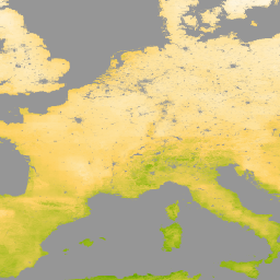
var dataset = ee.ImageCollection('MODIS/061/MYD16A2')\n .filter(ee.Filter.date('2021-01-01', '2021-02-01'));\nvar evapotranspiration = dataset.select('ET');\nvar evapotranspirationVis = {\n min: 0.0,\n max: 300.0,\n palette: [\n 'ffffff', 'fcd163', '99b718', '66a000', '3e8601', '207401', '056201',\n '004c00', '011301'\n ],\n};\nMap.setCenter(6.746, 46.529, 2);\nMap.addLayer(\n evapotranspiration, evapotranspirationVis, 'Evapotranspiration');\n```\n[Open in Code Editor](https://code.earthengine.google.com/?scriptPath=Examples:Datasets/MODIS/MODIS_061_MYD16A2) \n[MYD16A2.061: Aqua Net Evapotranspiration 8-Day L4 Global 500m SIN Grid V061](/earth-engine/datasets/catalog/MODIS_061_MYD16A2) \nThe MYD16A2 Version 6.1 Evapotranspiration/Latent Heat Flux product is an 8-day composite product at 500 meter pixel resolution. The algorithm used for the MOD16 data product collection is based on the logic of the Penman-Monteith equation, which includes inputs of daily meteorological reanalysis data along with MODIS remotely sensed data ... \nMODIS/061/MYD16A2, 8-day,evapotranspiration,global,modis,nasa,water-vapor \n2021-01-01T00:00:00Z/2025-08-13T00:00:00Z \n-90 -180 90 180 \nGoogle Earth Engine \nhttps://developers.google.com/earth-engine/datasets\n\n- [https://doi.org/10.5067/MODIS/MYD16A2.061](https://doi.org/https://doi.org/10.5067/MODIS/MYD16A2.061)\n- [https://doi.org/10.5067/MODIS/MYD16A2.061](https://doi.org/https://developers.google.com/earth-engine/datasets/catalog/MODIS_061_MYD16A2)"]]