- در دسترس بودن مجموعه دادهها
- 2002-07-04T00:00:00Z–2023-02-25T00:00:00Z
- تولیدکننده مجموعه داده
- گوگل
- کادانس
- ۱ روز
- برچسبها
- آبزی
روزانه
اوی
جهانی
مودیس
myd09ga
بازتاب سطحی
ایالات متحده
شاخصهای پوشش گیاهی
توضیحات
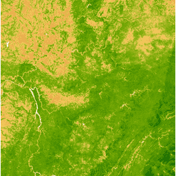
شاخص پوشش گیاهی بهبود یافته (EVI) از باندهای فروسرخ نزدیک، قرمز و آبی هر صحنه تولید میشود و مقدار آن از -1.0 تا 1.0 متغیر است. برای جزئیات بیشتر به Huete و همکاران (2002) مراجعه کنید. این محصول از کامپوزیتهای بازتاب سطحی MODIS/006/MYD09GA تولید شده است.
باندها
باندها
اندازه پیکسل: ۴۶۳.۳۱۳ متر (همه باندها)
| نام | اندازه پیکسل | توضیحات |
|---|---|---|
EVI | ۴۶۳.۳۱۳ متر | شاخص پوشش گیاهی پیشرفته |
شرایط استفاده
شرایط استفاده
دادهها و محصولات MODIS که از طریق LP DAAC به دست میآیند، هیچ محدودیتی در استفاده، فروش یا توزیع مجدد بعدی ندارند.
با موتور زمین کاوش کنید
ویرایشگر کد (جاوااسکریپت)
var dataset = ee.ImageCollection('MODIS/MYD09GA_006_EVI')
                  .filter(ee.Filter.date('2018-04-01', '2018-06-01'));
var colorized = dataset.select('EVI');
var colorizedVis = {
  min: 0,
  max: 1,
  palette: [
    'ffffff', 'ce7e45', 'df923d', 'f1b555', 'fcd163', '99b718', '74a901',
    '66a000', '529400', '3e8601', '207401', '056201', '004c00', '023b01',
    '012e01', '011d01', '011301'
  ],
};
Map.setCenter(-7.03, 31.05, 2);
Map.addLayer(colorized, colorizedVis, 'Colorized');