L'ensemble de données NASA NEX-GDDP est composé de scénarios climatiques à échelle réduite pour le monde entier, dérivés des exécutions du modèle de circulation générale (MCG) menées dans le cadre de la phase 5 du projet CMIP (Coupled Model Intercomparison Project, voir Taylor et al. 2012) et pour deux des quatre scénarios d'émissions de gaz à effet de serre connus sous le nom de Representative Concentration Pathways (RCP, voir Meinshausen et al. 2011).
Les simulations CMIP5 GCM ont été développées pour soutenir le cinquième rapport d'évaluation du Groupe d'experts intergouvernemental sur l'évolution du climat (GIEC AR5).
Cet ensemble de données a été préparé par le Climate Analytics Group et le NASA Ames Research Center à l'aide de NASA Earth Exchange, et distribué par le NASA Center for Climate Simulation (NCCS).
Bracelets
Taille des pixels 27830 mètres
Bandes de fréquences
Nom
Unités
Min
Max
Taille des pixels
Description
pr
kg/m^2/s
0*
0.42*
mètres
Moyenne quotidienne des précipitations en surface, incluant les phases liquides et solides de tous les types de nuages (à grande échelle et convectifs)
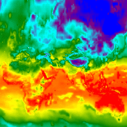
tasmin
K
165.31*
318,89*
mètres
Moyenne quotidienne de la température de l'air quotidienne minimale près de la surface
tasmax
K
188,38*
335,13*
mètres
Moyenne quotidienne de la température maximale quotidienne de l'air près de la surface
* valeur minimale ou maximale estimée
Propriétés des images
Propriétés de l'image
Nom
Type
Description
modèle
STRING
Nom du modèle CMIP5. Les valeurs possibles sont "ACCESS1-0", "bcc-csm1-1", "BNU-ESM", "CanESM2", "CCSM4", "CESM1-BGC", "CNRM-CM5",
"CSIRO-Mk3-6-0", "GFDL-CM3", "GFDL-ESM2G", "GFDL-ESM2M", "inmcm4",
"IPSL-CM5A-LR", "IPSL-CM5A-MR", "MIROC-ESM", "MIROC-ESM-CHEM", "MIROC5",
"MPI-ESM-LR", "MPI-ESM-MR", "MRI-CGCM3", "NorESM1-M".
scénario
STRING
Nom du scénario CMIP5. Il s'agit de l'une des valeurs suivantes : "historical", "rcp45" ou "rcp85". "historical" désigne les exécutions de modèles rétrospectives (avant 2006).
Thrasher, B., Maurer, E. P., McKellar, C., & Duffy, P. B. 2012 : Note technique : correction du biais des extrêmes de température quotidiens simulés par le modèle climatique avec mappage des quantiles. Hydrology and Earth System Sciences,
16(9), 3309-3314.
doi:10.5194/hess-16-3309-2012
L'ensemble de données NASA NEX-GDDP est composé de scénarios climatiques réduits pour le monde entier, dérivés des exécutions du modèle de circulation générale (MCG) menées dans le cadre du projet CMIP5 (Coupled Model Intercomparison Project Phase 5, voir Taylor et al. 2012) et dans deux des quatre scénarios d'émissions de gaz à effet de serre connus sous le nom de …
[null,null,[],[[["\u003cp\u003eThe NASA NEX-GDDP dataset provides downscaled climate scenarios derived from CMIP5 GCM runs, covering two greenhouse gas emissions scenarios (RCPs).\u003c/p\u003e\n"],["\u003cp\u003eIt includes daily projections of precipitation, minimum and maximum near-surface air temperature from 1950 to 2100 at a 27830-meter resolution.\u003c/p\u003e\n"],["\u003cp\u003eDeveloped by the Climate Analytics Group and NASA Ames Research Center, this dataset is publicly available without restrictions.\u003c/p\u003e\n"],["\u003cp\u003eData is available for various CMIP5 models and scenarios, including 'historical', 'rcp45', and 'rcp85'.\u003c/p\u003e\n"],["\u003cp\u003eUsers can explore the dataset and access code examples through the Google Earth Engine platform.\u003c/p\u003e\n"]]],[],null,["# NEX-GDDP: NASA Earth Exchange Global Daily Downscaled Climate Projections\n\nDataset Availability\n: 1950-01-01T00:00:00Z--2100-12-31T00:00:00Z\n\nDataset Provider\n:\n\n\n [NASA / Climate Analytics Group](https://www.nccs.nasa.gov/services/data-collections/land-based-products/nex-gddp)\n\nCadence\n: 1 Day\n\nTags\n:\n[cag](/earth-engine/datasets/tags/cag) [climate](/earth-engine/datasets/tags/climate) [cmip5](/earth-engine/datasets/tags/cmip5) [gddp](/earth-engine/datasets/tags/gddp) [geophysical](/earth-engine/datasets/tags/geophysical) [ipcc](/earth-engine/datasets/tags/ipcc) [nasa](/earth-engine/datasets/tags/nasa) [nex](/earth-engine/datasets/tags/nex) [precipitation](/earth-engine/datasets/tags/precipitation) [temperature](/earth-engine/datasets/tags/temperature) \n\n#### Description\n\nThe NASA NEX-GDDP dataset is comprised of downscaled climate scenarios\nfor the globe that are derived from the General Circulation Model (GCM)\nruns conducted under the Coupled Model Intercomparison Project Phase 5\n(CMIP5, see [Taylor et al. 2012](https://journals.ametsoc.org/doi/abs/10.1175/BAMS-D-11-00094.1))\nand across two of the four greenhouse gas emissions scenarios known as\nRepresentative Concentration Pathways (RCPs, see [Meinshausen et\nal. 2011](https://rd.springer.com/article/10.1007%2Fs10584-011-0156-z#page-1)).\nThe CMIP5 GCM runs were developed in support of the Fifth Assessment\nReport of the Intergovernmental Panel on Climate Change (IPCC AR5).\n\nThis dataset was prepared by the Climate Analytics Group and NASA Ames\nResearch Center using the NASA Earth Exchange, and distributed by the NASA\nCenter for Climate Simulation (NCCS).\n\n### Bands\n\n\n**Pixel Size**\n\n27830 meters\n\n**Bands**\n\n| Name | Units | Min | Max | Pixel Size | Description |\n|----------|-----------|----------|----------|------------|------------------------------------------------------------------------------------------------------------------------------------------|\n| `pr` | kg/m\\^2/s | 0\\* | 0.42\\* | meters | Daily mean of precipitation at surface; includes both liquid and solid phases from all types of clouds (both large-scale and convective) |\n| `tasmin` | K | 165.31\\* | 318.89\\* | meters | Daily mean of the daily-minimum near-surface air temperature |\n| `tasmax` | K | 188.38\\* | 335.13\\* | meters | Daily mean of the daily-maximum near-surface air temperature |\n\n\\* estimated min or max value\n\n### Image Properties\n\n**Image Properties**\n\n| Name | Type | Description |\n|----------|--------|----------------------------------------------------------------------------------------------------------------------------------------------------------------------------------------------------------------------------------------------------------------------------------------------------------------------------|\n| model | STRING | Name of the CMIP5 model. It is one of 'ACCESS1-0', 'bcc-csm1-1', 'BNU-ESM', 'CanESM2', 'CCSM4', 'CESM1-BGC', 'CNRM-CM5', 'CSIRO-Mk3-6-0', 'GFDL-CM3', 'GFDL-ESM2G', 'GFDL-ESM2M', 'inmcm4', 'IPSL-CM5A-LR', 'IPSL-CM5A-MR', 'MIROC-ESM', 'MIROC-ESM-CHEM', 'MIROC5', 'MPI-ESM-LR', 'MPI-ESM-MR', 'MRI-CGCM3', 'NorESM1-M'. |\n| scenario | STRING | Name of the CMIP5 scenario. It is one of: 'historical', 'rcp45', 'rcp85', where 'historical' designates retrospective model runs (pre-2006). |\n| year | DOUBLE | Calendar year |\n| month | DOUBLE | Calendar month |\n| day | DOUBLE | Calendar day |\n\n### Terms of Use\n\n**Terms of Use**\n\nThis dataset is in the public domain and is available\nwithout restriction on use and distribution. See [NASA's\nEarth Science Data \\& Information Policy](https://www.earthdata.nasa.gov/engage/open-data-services-and-software/data-and-information-policy)\nfor additional information.\n\n### Citations\n\nCitations:\n\n- Thrasher, B., Maurer, E. P., McKellar, C., \\& Duffy, P. B., 2012:\n Technical Note: Bias correcting climate model simulated daily temperature\n extremes with quantile mapping. Hydrology and Earth System Sciences,\n 16(9), 3309-3314.\n [doi:10.5194/hess-16-3309-2012](https://doi.org/10.5194/hess-16-3309-2012)\n\n### Explore with Earth Engine\n\n| **Important:** Earth Engine is a platform for petabyte-scale scientific analysis and visualization of geospatial datasets, both for public benefit and for business and government users. Earth Engine is free to use for research, education, and nonprofit use. To get started, please [register for Earth Engine access.](https://console.cloud.google.com/earth-engine)\n\n### Code Editor (JavaScript)\n\n```javascript\nvar dataset = ee.ImageCollection('NASA/NEX-GDDP')\n .filter(ee.Filter.date('2018-07-01', '2018-07-02'));\nvar minimumAirTemperature = dataset.select('tasmin');\nvar minimumAirTemperatureVis = {\n min: 240.0,\n max: 300.0,\n palette: ['blue', 'purple', 'cyan', 'green', 'yellow', 'red'],\n};\nMap.setCenter(71.72, 52.48, 3.0);\nMap.addLayer(\n minimumAirTemperature, minimumAirTemperatureVis, 'Minimum Air Temperature');\n```\n[Open in Code Editor](https://code.earthengine.google.com/?scriptPath=Examples:Datasets/NASA/NASA_NEX-GDDP) \n[NEX-GDDP: NASA Earth Exchange Global Daily Downscaled Climate Projections](/earth-engine/datasets/catalog/NASA_NEX-GDDP) \nThe NASA NEX-GDDP dataset is comprised of downscaled climate scenarios for the globe that are derived from the General Circulation Model (GCM) runs conducted under the Coupled Model Intercomparison Project Phase 5 (CMIP5, see Taylor et al. 2012) and across two of the four greenhouse gas emissions scenarios known as ... \nNASA/NEX-GDDP, cag,climate,cmip5,gddp,geophysical,ipcc,nasa,nex,precipitation,temperature \n1950-01-01T00:00:00Z/2100-12-31T00:00:00Z \n-90 -180 90 180 \nGoogle Earth Engine \nhttps://developers.google.com/earth-engine/datasets\n\n- [](https://doi.org/https://www.nccs.nasa.gov/services/data-collections/land-based-products/nex-gddp)\n- [](https://doi.org/https://developers.google.com/earth-engine/datasets/catalog/NASA_NEX-GDDP)"]]