NASA NEX-GDDP 데이터 세트는 접합 대순환 모델 5 (CMIP5, Taylor et al. 2012 참고)에 따라 실행된 일반 순환 모델(GCM)에서 파생되고 대표 농도 경로 (RCP, Meinshausen et al. 2011 참고)로 알려진 4가지 온실가스 배출 시나리오 중 2가지에 걸쳐 있는 전 세계의 다운스케일링된 기후 시나리오로 구성됩니다.
CMIP5 GCM 실행은 기후 변화에 관한 정부 간 패널 (IPCC AR5)의 5차 평가 보고서를 지원하기 위해 개발되었습니다.
이 데이터 세트는 Climate Analytics Group과 NASA Ames Research Center가 NASA Earth Exchange를 사용하여 준비하고 NASA Center for Climate Simulation (NCCS)에서 배포했습니다.
대역
픽셀 크기 27830미터
대역
이름
단위
최소
최대
픽셀 크기
설명
pr
kg/m^2/s
0*
0.42*
미터
지표면의 일일 평균 강수량입니다. 모든 유형의 구름 (대규모 및 대류)에서 발생하는 액체 및 고체 단계를 모두 포함합니다.
Thrasher, B., Maurer, E. P., McKellar, C., & Duffy, P. B., 2012년:
기술 참고: 분위수 매핑을 사용하여 기후 모델 시뮬레이션 일일 온도 극단값의 편향 수정 Hydrology and Earth System Sciences,
16(9), 3309-3314.
doi:10.5194/hess-16-3309-2012
NASA NEX-GDDP 데이터 세트는 결합 모델 비교 프로젝트 5단계 (CMIP5, Taylor et al. 2012 참고)에 따라 실행된 일반 순환 모델 (GCM)에서 파생되고, …로 알려진 4가지 온실가스 배출 시나리오 중 2가지에 걸쳐 있는 전 세계의 다운스케일링된 기후 시나리오로 구성됩니다.
[null,null,[],[[["\u003cp\u003eThe NASA NEX-GDDP dataset provides downscaled climate scenarios derived from CMIP5 GCM runs, covering two greenhouse gas emissions scenarios (RCPs).\u003c/p\u003e\n"],["\u003cp\u003eIt includes daily projections of precipitation, minimum and maximum near-surface air temperature from 1950 to 2100 at a 27830-meter resolution.\u003c/p\u003e\n"],["\u003cp\u003eDeveloped by the Climate Analytics Group and NASA Ames Research Center, this dataset is publicly available without restrictions.\u003c/p\u003e\n"],["\u003cp\u003eData is available for various CMIP5 models and scenarios, including 'historical', 'rcp45', and 'rcp85'.\u003c/p\u003e\n"],["\u003cp\u003eUsers can explore the dataset and access code examples through the Google Earth Engine platform.\u003c/p\u003e\n"]]],[],null,["# NEX-GDDP: NASA Earth Exchange Global Daily Downscaled Climate Projections\n\nDataset Availability\n: 1950-01-01T00:00:00Z--2100-12-31T00:00:00Z\n\nDataset Provider\n:\n\n\n [NASA / Climate Analytics Group](https://www.nccs.nasa.gov/services/data-collections/land-based-products/nex-gddp)\n\nCadence\n: 1 Day\n\nTags\n:\n[cag](/earth-engine/datasets/tags/cag) [climate](/earth-engine/datasets/tags/climate) [cmip5](/earth-engine/datasets/tags/cmip5) [gddp](/earth-engine/datasets/tags/gddp) [geophysical](/earth-engine/datasets/tags/geophysical) [ipcc](/earth-engine/datasets/tags/ipcc) [nasa](/earth-engine/datasets/tags/nasa) [nex](/earth-engine/datasets/tags/nex) [precipitation](/earth-engine/datasets/tags/precipitation) [temperature](/earth-engine/datasets/tags/temperature) \n\n#### Description\n\nThe NASA NEX-GDDP dataset is comprised of downscaled climate scenarios\nfor the globe that are derived from the General Circulation Model (GCM)\nruns conducted under the Coupled Model Intercomparison Project Phase 5\n(CMIP5, see [Taylor et al. 2012](https://journals.ametsoc.org/doi/abs/10.1175/BAMS-D-11-00094.1))\nand across two of the four greenhouse gas emissions scenarios known as\nRepresentative Concentration Pathways (RCPs, see [Meinshausen et\nal. 2011](https://rd.springer.com/article/10.1007%2Fs10584-011-0156-z#page-1)).\nThe CMIP5 GCM runs were developed in support of the Fifth Assessment\nReport of the Intergovernmental Panel on Climate Change (IPCC AR5).\n\nThis dataset was prepared by the Climate Analytics Group and NASA Ames\nResearch Center using the NASA Earth Exchange, and distributed by the NASA\nCenter for Climate Simulation (NCCS).\n\n### Bands\n\n\n**Pixel Size**\n\n27830 meters\n\n**Bands**\n\n| Name | Units | Min | Max | Pixel Size | Description |\n|----------|-----------|----------|----------|------------|------------------------------------------------------------------------------------------------------------------------------------------|\n| `pr` | kg/m\\^2/s | 0\\* | 0.42\\* | meters | Daily mean of precipitation at surface; includes both liquid and solid phases from all types of clouds (both large-scale and convective) |\n| `tasmin` | K | 165.31\\* | 318.89\\* | meters | Daily mean of the daily-minimum near-surface air temperature |\n| `tasmax` | K | 188.38\\* | 335.13\\* | meters | Daily mean of the daily-maximum near-surface air temperature |\n\n\\* estimated min or max value\n\n### Image Properties\n\n**Image Properties**\n\n| Name | Type | Description |\n|----------|--------|----------------------------------------------------------------------------------------------------------------------------------------------------------------------------------------------------------------------------------------------------------------------------------------------------------------------------|\n| model | STRING | Name of the CMIP5 model. It is one of 'ACCESS1-0', 'bcc-csm1-1', 'BNU-ESM', 'CanESM2', 'CCSM4', 'CESM1-BGC', 'CNRM-CM5', 'CSIRO-Mk3-6-0', 'GFDL-CM3', 'GFDL-ESM2G', 'GFDL-ESM2M', 'inmcm4', 'IPSL-CM5A-LR', 'IPSL-CM5A-MR', 'MIROC-ESM', 'MIROC-ESM-CHEM', 'MIROC5', 'MPI-ESM-LR', 'MPI-ESM-MR', 'MRI-CGCM3', 'NorESM1-M'. |\n| scenario | STRING | Name of the CMIP5 scenario. It is one of: 'historical', 'rcp45', 'rcp85', where 'historical' designates retrospective model runs (pre-2006). |\n| year | DOUBLE | Calendar year |\n| month | DOUBLE | Calendar month |\n| day | DOUBLE | Calendar day |\n\n### Terms of Use\n\n**Terms of Use**\n\nThis dataset is in the public domain and is available\nwithout restriction on use and distribution. See [NASA's\nEarth Science Data \\& Information Policy](https://www.earthdata.nasa.gov/engage/open-data-services-and-software/data-and-information-policy)\nfor additional information.\n\n### Citations\n\nCitations:\n\n- Thrasher, B., Maurer, E. P., McKellar, C., \\& Duffy, P. B., 2012:\n Technical Note: Bias correcting climate model simulated daily temperature\n extremes with quantile mapping. Hydrology and Earth System Sciences,\n 16(9), 3309-3314.\n [doi:10.5194/hess-16-3309-2012](https://doi.org/10.5194/hess-16-3309-2012)\n\n### Explore with Earth Engine\n\n| **Important:** Earth Engine is a platform for petabyte-scale scientific analysis and visualization of geospatial datasets, both for public benefit and for business and government users. Earth Engine is free to use for research, education, and nonprofit use. To get started, please [register for Earth Engine access.](https://console.cloud.google.com/earth-engine)\n\n### Code Editor (JavaScript)\n\n```javascript\n
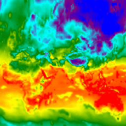
var dataset = ee.ImageCollection('NASA/NEX-GDDP')\n .filter(ee.Filter.date('2018-07-01', '2018-07-02'));\nvar minimumAirTemperature = dataset.select('tasmin');\nvar minimumAirTemperatureVis = {\n min: 240.0,\n max: 300.0,\n palette: ['blue', 'purple', 'cyan', 'green', 'yellow', 'red'],\n};\nMap.setCenter(71.72, 52.48, 3.0);\nMap.addLayer(\n minimumAirTemperature, minimumAirTemperatureVis, 'Minimum Air Temperature');\n```\n[Open in Code Editor](https://code.earthengine.google.com/?scriptPath=Examples:Datasets/NASA/NASA_NEX-GDDP) \n[NEX-GDDP: NASA Earth Exchange Global Daily Downscaled Climate Projections](/earth-engine/datasets/catalog/NASA_NEX-GDDP) \nThe NASA NEX-GDDP dataset is comprised of downscaled climate scenarios for the globe that are derived from the General Circulation Model (GCM) runs conducted under the Coupled Model Intercomparison Project Phase 5 (CMIP5, see Taylor et al. 2012) and across two of the four greenhouse gas emissions scenarios known as ... \nNASA/NEX-GDDP, cag,climate,cmip5,gddp,geophysical,ipcc,nasa,nex,precipitation,temperature \n1950-01-01T00:00:00Z/2100-12-31T00:00:00Z \n-90 -180 90 180 \nGoogle Earth Engine \nhttps://developers.google.com/earth-engine/datasets\n\n- [](https://doi.org/https://www.nccs.nasa.gov/services/data-collections/land-based-products/nex-gddp)\n- [](https://doi.org/https://developers.google.com/earth-engine/datasets/catalog/NASA_NEX-GDDP)"]]