- Dostępność zbioru danych
- 1950-01-01T00:00:00Z–2100-12-31T00:00:00Z
- Dostawca zbioru danych
- NASA / Climate Analytics Group
- Częstotliwość
- 1 dzień
- Tagi
Opis
Zbiór danych NASA NEX-GDDP zawiera globalne scenariusze klimatyczne o zmniejszonej rozdzielczości, które pochodzą z modeli ogólnej cyrkulacji (GCM) przeprowadzonych w ramach projektu Coupled Model Intercomparison Project Phase 5 (CMIP5, patrz Taylor i in. 2012) i w ramach dwóch z czterech scenariuszy emisji gazów cieplarnianych znanych jako Representative Concentration Pathways (RCP, patrz Meinshausen i in. 2011). Modele GCM CMIP5 zostały opracowane na potrzeby piątego raportu oceniającego Międzyrządowego Zespołu ds. Zmian Klimatu (IPCC AR5).
Ten zbiór danych został przygotowany przez Climate Analytics Group i NASA Ames Research Center przy użyciu NASA Earth Exchange i jest rozpowszechniany przez NASA Center for Climate Simulation (NCCS).
Pasma
Pasma
Rozmiar piksela: 27 830 m (wszystkie pasma)
| Nazwa | Jednostki | Min. | Maks. | Rozmiar piksela | Opis |
|---|---|---|---|---|---|
pr |
kg/m^2/s | 0* | 0,42* | 27830 metrów | Średnia dzienna wartość opadów na powierzchni; obejmuje zarówno fazę ciekłą, jak i stałą ze wszystkich rodzajów chmur (zarówno wielkoskalowych, jak i konwekcyjnych). |
tasmin |
K | 165,31* | 318,89* | 27830 metrów | Średnia dzienna minimalnej temperatury powietrza przy powierzchni ziemi |
tasmax |
K | 188,38* | 335,13* | 27830 metrów | Średnia dzienna maksymalnej temperatury powietrza przy powierzchni ziemi |
Właściwości obrazu
Właściwości obrazu
| Nazwa | Typ | Opis |
|---|---|---|
| model | CIĄG ZNAKÓW | Nazwa modelu CMIP5. Może przyjmować jedną z wartości: „ACCESS1-0”, „bcc-csm1-1”, „BNU-ESM”, „CanESM2”, „CCSM4”, „CESM1-BGC”, „CNRM-CM5”, „CSIRO-Mk3-6-0”, „GFDL-CM3”, „GFDL-ESM2G”, „GFDL-ESM2M”, „inmcm4”, „IPSL-CM5A-LR”, „IPSL-CM5A-MR”, „MIROC-ESM”, „MIROC-ESM-CHEM”, „MIROC5”, „MPI-ESM-LR”, „MPI-ESM-MR”, „MRI-CGCM3”, „NorESM1-M”. |
| scenariusz, | CIĄG ZNAKÓW | Nazwa scenariusza CMIP5. Może to być jedna z wartości: „historical”, „rcp45”, „rcp85”, gdzie „historical” oznacza retrospektywne uruchomienia modelu (sprzed 2006 r.). |
| rok | LICZBA ZMIENNOPRZECINKOWA O PODWÓJNEJ PRECYZJI | Rok kalendarzowy |
| miesiąc | LICZBA ZMIENNOPRZECINKOWA O PODWÓJNEJ PRECYZJI | Miesiąc kalendarzowy |
| dzień | LICZBA ZMIENNOPRZECINKOWA O PODWÓJNEJ PRECYZJI | Dzień kalendarzowy |
Warunki korzystania z usługi
Warunki korzystania z usługi
Ten zbiór danych należy do domeny publicznej i jest dostępny bez ograniczeń dotyczących użytkowania i dystrybucji. Więcej informacji znajdziesz w zasadach NASA dotyczących danych i informacji o naukach o Ziemi.
Cytaty
Thrasher, B., Maurer, E. P., McKellar, C., & Duffy, P. B., 2012: Technical Note: Bias correcting climate model simulated daily temperature extremes with quantile mapping. Hydrology and Earth System Sciences, 16(9), 3309–3314. doi:10.5194/hess-16-3309-2012
Odkrywaj za pomocą Earth Engine
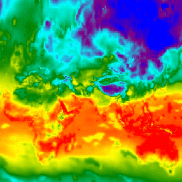
Edytor kodu (JavaScript)
var dataset = ee.ImageCollection('NASA/NEX-GDDP')
                  .filter(ee.Filter.date('2018-07-01', '2018-07-02'));
var minimumAirTemperature = dataset.select('tasmin');
var minimumAirTemperatureVis = {
  min: 240.0,
  max: 300.0,
  palette: ['blue', 'purple', 'cyan', 'green', 'yellow', 'red'],
};
Map.setCenter(71.72, 52.48, 3.0);
Map.addLayer(
    minimumAirTemperature, minimumAirTemperatureVis, 'Minimum Air Temperature');