Daymet V4 zawiera oszacowania w postaci siatki dziennych parametrów pogodowych dla kontynentalnej części Ameryki Północnej, Hawajów i Portoryko (dane dla Portoryko są dostępne od 1950 r.). Jest ona obliczana na podstawie danych z wybranych stacji meteorologicznych i różnych źródeł danych pomocniczych.
W porównaniu z poprzednią wersją Daymet V4 zapewnia skuteczne rozwiązania znanych problemów i uwzględnia ulepszenia w zakresie tego, co uważano za odchylenia stacji pogodowych.
Ulepszenia obejmują:
Zmniejszenie odchylenia czasowego w pomiarach stacji pogodowych.
Ulepszenie technik trójwymiarowego modelu regresji w algorytmie podstawowym.
Nowatorskie podejście do radzenia sobie z odchyleniami pomiarów temperatury na dużych wysokościach.
Dane z lat 2020 i 2021 są pobierane ze źródeł V4 R1.
Thornton, M.M., R. Shrestha, Y. Wei, P.E. Thornton, S-C. Kao i B.E. Wilson. 2022 r.
Daymet: Daily Surface Weather Data on a 1-km Grid for North America, Version 4 R1.
ORNL DAAC, Oak Ridge, Tennessee, USA. https://doi.org/10.3334/ORNLDAAC/2129
Inne szczegóły cytowania – Thornton, M.M., R. Shrestha, Y. Wei, P.E. Thornton, S. Kao i B.E. Wilson. 2020.
Daymet: Daily Surface Weather Data on a 1-km Grid for North America, Version 4. ORNL DAAC, Oak Ridge, Tennessee, USA.
doi:10.3334/ORNLDAAC/1840
Daymet V4 zawiera oszacowania w postaci siatki dziennych parametrów pogodowych dla kontynentalnej części Ameryki Północnej, Hawajów i Portoryko (dane dla Portoryko są dostępne od 1950 roku). Jest ona obliczana na podstawie danych z wybranych stacji meteorologicznych i różnych pomocniczych źródeł danych. W porównaniu z poprzednią wersją Daymet V4 zapewnia skuteczne rozwiązania w zakresie…
[null,null,[],[[["\u003cp\u003eDaymet V4 provides daily gridded estimates of weather parameters (e.g., precipitation, temperature, radiation) for North America, Hawaii, and Puerto Rico from 1980 to 2023 (Puerto Rico data starts in 1950).\u003c/p\u003e\n"],["\u003cp\u003eThe dataset includes daily minimum and maximum temperature, precipitation, shortwave radiation, snow water equivalent, vapor pressure, and daylight duration.\u003c/p\u003e\n"],["\u003cp\u003eDaymet V4 is available at a 1km spatial resolution and is based on meteorological station data and various supporting sources, offering improvements over previous versions in addressing biases.\u003c/p\u003e\n"],["\u003cp\u003eThis dataset is in the public domain and freely accessible for use and distribution.\u003c/p\u003e\n"],["\u003cp\u003eThe dataset is provided by NASA ORNL DAAC and can be accessed and analyzed using Google Earth Engine.\u003c/p\u003e\n"]]],[],null,["# Daymet V4: Daily Surface Weather and Climatological Summaries\n\nDataset Availability\n: 1980-01-01T00:00:00Z--2023-12-31T00:00:00Z\n\nDataset Provider\n:\n\n\n [NASA ORNL DAAC at Oak Ridge National Laboratory](https://doi.org/10.3334/ORNLDAAC/1840)\n\nCadence\n: 1 Day\n\nTags\n:\n [climate](/earth-engine/datasets/tags/climate) [daily](/earth-engine/datasets/tags/daily) [daylight](/earth-engine/datasets/tags/daylight) [flux](/earth-engine/datasets/tags/flux) [geophysical](/earth-engine/datasets/tags/geophysical) [nasa](/earth-engine/datasets/tags/nasa) [ornl](/earth-engine/datasets/tags/ornl) [precipitation](/earth-engine/datasets/tags/precipitation) [radiation](/earth-engine/datasets/tags/radiation) [snow](/earth-engine/datasets/tags/snow) [temperature](/earth-engine/datasets/tags/temperature) [vapor](/earth-engine/datasets/tags/vapor) [water](/earth-engine/datasets/tags/water) [weather](/earth-engine/datasets/tags/weather) \ndaymet \n\n#### Description\n\nDaymet V4 provides gridded estimates of daily weather parameters for\nContinental North America, Hawaii, and Puerto Rico (Data for Puerto Rico is available starting\nin 1950). It is derived from selected meteorological station data and various supporting data\nsources.\n\nCompared to the previous version, Daymet V4 provides effective solutions to known issues and\nfurther considers improvements to what were believed to be input weather station biases.\nImprovements include:\n\n- Reductions in the timing bias of input reporting weather station measurements.\n\n- Improvement to the three-dimensional regression model techniques in the core algorithm.\n\n- A novel approach to handling high elevation temperature measurement biases.\n\n2020 and 2021 data are ingested from V4 R1 sources\n\nDocumentation:\n\n- [ORNL DAAC Dataset Documentation](https://daac.ornl.gov/DAYMET/guides/Daymet_Daily_V4.html)\n\n- [Dataset Documentation](https://daac.ornl.gov/daacdata/daymet/Daymet_Daily_V4/comp/Daymet_Daily_V4.pdf)\n\n- [The THREDDS location for this Collection](https://thredds.daac.ornl.gov/thredds/catalogs/ornldaac/Regional_and_Global_Data/DAYMET_COLLECTIONS/DAYMET_COLLECTIONS.html)\n\n### Bands\n\n\n**Pixel Size**\n\n1000 meters\n\n**Bands**\n\n| Name | Units | Min | Max | Pixel Size | Description |\n|--------|---------|-------|---------|------------|----------------------------------------------------------------------------------------------------------------------------|\n| `dayl` | seconds | 0\\* | 86400\\* | meters | Duration of the daylight period. Based on the period of the day during which the sun is above a hypothetical flat horizon. |\n| `prcp` | mm | 0\\* | 544\\* | meters | Daily total precipitation, sum of all forms converted to water-equivalent. |\n| `srad` | W/m\\^2 | 0\\* | 1051\\* | meters | Incident shortwave radiation flux density, taken as an average over the daylight period of the day. |\n| `swe` | kg/m\\^2 | 0\\* | 13931\\* | meters | Snow water equivalent, the amount of water contained within the snowpack. |\n| `tmax` | °C | -60\\* | 60\\* | meters | Daily maximum 2-meter air temperature. |\n| `tmin` | °C | -60\\* | 42\\* | meters | Daily minimum 2-meter air temperature. |\n| `vp` | Pa | 0\\* | 8230\\* | meters | Daily average partial pressure of water vapor. |\n\n\\* estimated min or max value\n\n### Terms of Use\n\n**Terms of Use**\n\nThis dataset is in the public domain and is available\nwithout restriction on use and distribution. See [NASA's\nEarth Science Data \\& Information Policy](https://www.earthdata.nasa.gov/engage/open-data-services-and-software/data-and-information-policy)\nfor additional information.\n\n### Citations\n\nCitations:\n\n- Thornton, M.M., R. Shrestha, Y. Wei, P.E. Thornton, S-C. Kao, and B.E. Wilson. 2022.\n Daymet: Daily Surface Weather Data on a 1-km Grid for North America, Version 4 R1.\n ORNL DAAC, Oak Ridge, Tennessee, USA. https://doi.org/10.3334/ORNLDAAC/2129\n- Other Citation Details - Thornton, M.M., R. Shrestha, Y. Wei, P.E. Thornton, S. Kao, and B.E. Wilson. 2020.\n Daymet: Daily Surface Weather Data on a 1-km Grid for North America, Version 4. ORNL DAAC, Oak Ridge, Tennessee, USA.\n [doi:10.3334/ORNLDAAC/1840](https://doi.org/10.3334/ORNLDAAC/1840)\n\n### DOIs\n\n- \u003chttps://doi.org/10.3334/ORNLDAAC/1840\u003e\n- \u003chttps://doi.org/10.3334/ORNLDAAC/2129\u003e\n\n### Explore with Earth Engine\n\n| **Important:** Earth Engine is a platform for petabyte-scale scientific analysis and visualization of geospatial datasets, both for public benefit and for business and government users. Earth Engine is free to use for research, education, and nonprofit use. To get started, please [register for Earth Engine access.](https://console.cloud.google.com/earth-engine)\n\n### Code Editor (JavaScript)\n\n```javascript\n
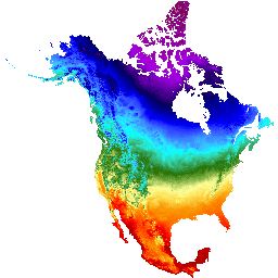
var dataset = ee.ImageCollection('NASA/ORNL/DAYMET_V4')\n .filter(ee.Filter.date('2017-04-01', '2017-04-30'));\nvar maximumTemperature = dataset.select('tmax');\nvar maximumTemperatureVis = {\n min: -40.0,\n max: 30.0,\n palette: ['1621A2', 'white', 'cyan', 'green', 'yellow', 'orange', 'red'],\n};\nMap.setCenter(-110.21, 35.1, 4);\nMap.addLayer(maximumTemperature, maximumTemperatureVis, 'Maximum Temperature');\n```\n[Open in Code Editor](https://code.earthengine.google.com/?scriptPath=Examples:Datasets/NASA/NASA_ORNL_DAYMET_V4) \n[Daymet V4: Daily Surface Weather and Climatological Summaries](/earth-engine/datasets/catalog/NASA_ORNL_DAYMET_V4) \nDaymet V4 provides gridded estimates of daily weather parameters for Continental North America, Hawaii, and Puerto Rico (Data for Puerto Rico is available starting in 1950). It is derived from selected meteorological station data and various supporting data sources. Compared to the previous version, Daymet V4 provides effective solutions to ... \nNASA/ORNL/DAYMET_V4, climate,daily,daylight,flux,geophysical,nasa,ornl,precipitation,radiation,snow,temperature,vapor,water,weather \n1980-01-01T00:00:00Z/2023-12-31T00:00:00Z \n1.6 -150.8 84 -1.1 \nGoogle Earth Engine \nhttps://developers.google.com/earth-engine/datasets\n\n- [https://doi.org/10.3334/ORNLDAAC/2129](https://doi.org/https://doi.org/10.3334/ORNLDAAC/1840)\n- [https://doi.org/10.3334/ORNLDAAC/2129](https://doi.org/https://developers.google.com/earth-engine/datasets/catalog/NASA_ORNL_DAYMET_V4)"]]