- Disponibilidade de conjuntos de dados
- 2012-01-19T00:00:00Z–2025-12-19T00:00:00Z
- Provedor de conjunto de dados
- NASA LP DAAC no USGS EROS Center
- Cadência
- 1 dia
- Tags
Descrição
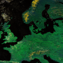
O produto composto de 8 dias de refletância da superfície do Visible Infrared Imaging Radiometer Suite (VIIRS) (VNP09H1), versão 1, fornece uma estimativa da refletância da superfície terrestre do sensor VIIRS da Suomi National Polar-orbiting Partnership (Suomi NPP) para três bandas de imagens (I1, I2, I3) com resolução nominal de 500 m (~463 m). O conjunto de dados de 500 m é derivado da reamostragem da resolução nativa de 375 m do VIIRS no produto de entrada L2. Os dados são corrigidos para condições atmosféricas, como os efeitos de gases moleculares, incluindo ozônio e vapor d'água, e para os efeitos de aerossóis atmosféricos. Cada pixel representa a melhor observação possível de nível 2G durante um período de oito dias, que é selecionado com base em alta cobertura de observação, baixo ângulo do sensor, ausência de nuvens ou sombra de nuvens e carga de aerossol. As três bandas de refletância. Este produto inclui uma camada de controle de qualidade (QA) de estado e uma camada de qualidade de banda de refletância.
Documentação:
Bandas
Tamanho do pixel
500 metros
Bandas
| Nome | Mín. | Máx. | Tamanho do pixel | Descrição | |||||||||||||||||||||||||||||||||||||||||||||||||||||||||||||||||||||||||||||||||||||||||||||||
|---|---|---|---|---|---|---|---|---|---|---|---|---|---|---|---|---|---|---|---|---|---|---|---|---|---|---|---|---|---|---|---|---|---|---|---|---|---|---|---|---|---|---|---|---|---|---|---|---|---|---|---|---|---|---|---|---|---|---|---|---|---|---|---|---|---|---|---|---|---|---|---|---|---|---|---|---|---|---|---|---|---|---|---|---|---|---|---|---|---|---|---|---|---|---|---|---|---|---|---|
SurfReflect_I1 |
-100 | 16.000 | metros | Banda de refletância da superfície de 500 m I1 |
|||||||||||||||||||||||||||||||||||||||||||||||||||||||||||||||||||||||||||||||||||||||||||||||
SurfReflect_I2 |
-100 | 16.000 | metros | Banda de refletância da superfície de 500 m I2 |
|||||||||||||||||||||||||||||||||||||||||||||||||||||||||||||||||||||||||||||||||||||||||||||||
SurfReflect_I3 |
-100 | 16.000 | metros | Banda de refletância da superfície de 500 m I3 |
|||||||||||||||||||||||||||||||||||||||||||||||||||||||||||||||||||||||||||||||||||||||||||||||
SurfReflect_QC_500m |
metros | Controle de qualidade (QC) da banda de refletância da superfície |
|||||||||||||||||||||||||||||||||||||||||||||||||||||||||||||||||||||||||||||||||||||||||||||||||
SurfReflect_State_500m |
metros | Controle de qualidade (QA) do estado de refletância da superfície |
|||||||||||||||||||||||||||||||||||||||||||||||||||||||||||||||||||||||||||||||||||||||||||||||||
Termos de Uso
Termos de Uso
Os dados da NASA do LP DAAC são de livre acesso. No entanto, quando um autor publica esses dados ou trabalhos baseados neles, é necessário citar os conjuntos de dados no texto da publicação e incluir uma referência a eles na lista de referências.
Citações
Acesse a página "Citing Our Data" (Como citar nossos dados) do LP DAAC (em inglês).
DOIs
Explore com o Earth Engine
Editor de código (JavaScript)
var dataset = ee.ImageCollection('NASA/VIIRS/002/VNP09H1')
                  .filter(ee.Filter.date('2017-05-01', '2017-06-30'));
var rgb = dataset.select(['SurfReflect_I1', 'SurfReflect_I2', 'SurfReflect_I3']);
var rgbVis = {
  min: 0.0,
  max: 1.0,
};
Map.setCenter(17.93, 7.71, 2);
Map.addLayer(rgb, rgbVis, 'RGB');