NASA Suomi ন্যাশনাল পোলার-অরবিটিং পার্টনারশিপ (Suomi NPP) দৃশ্যমান ইনফ্রারেড ইমেজিং রেডিওমিটার স্যুট (VIIRS) ল্যান্ড সারফেস টেম্পারেচার অ্যান্ড ইমিসিভিটি (LST&E) নাইট ভার্সন 1 প্রোডাক্ট (VNP21A1N) রাতের বেলা লেভেল 2 ইন্টারমিডিয়া (L2G) পণ্য থেকে প্রতিদিন কম্পাইল করা হয়।
L2G প্রক্রিয়া দৈনিক VNP21 swath granules একটি sinusoidal MODIS গ্রিডে ম্যাপ করে এবং একটি নির্দিষ্ট রাতের জন্য একটি গ্রিড করা সেলকে ওভারল্যাপ করা সমস্ত পর্যবেক্ষণ সংরক্ষণ করে। VNP21A1 অ্যালগরিদম প্রতিটি কক্ষের জন্য এই সমস্ত পর্যবেক্ষণের মাধ্যমে সাজায় এবং ভাল LST নির্ভুলতা আছে এমন সমস্ত ক্লাউড-মুক্ত পর্যবেক্ষণ থেকে গড় হিসাবে চূড়ান্ত LST মান অনুমান করে৷ শুধুমাত্র একটি নির্দিষ্ট থ্রেশহোল্ডের (15%) চেয়ে বেশি পর্যবেক্ষণ কভারেজ থাকা পর্যবেক্ষণগুলিকে এই গড়ের জন্য বিবেচনা করা হয়।
0: পিক্সেল তৈরি, ভালো মানের, আর QA তথ্যের প্রয়োজন নেই
1: পিক্সেল উত্পাদিত কিন্তু অবিশ্বাস্য গুণমান
2: মেঘের কারণে পিক্সেল তৈরি হয় না
3: ক্লাউড ব্যতীত অন্য কারণে পিক্সেল তৈরি হয় না
বিটস 2-3: ডেটা মানের পতাকা
0: L1B ব্যান্ড 14, 15, 16 এর ভালো ডেটা কোয়ালিটি
1: পিক্সেল অনুপস্থিত
2: মোটামুটি ক্রমাঙ্কিত
3: খারাপভাবে ক্যালিব্রেট করা হয়েছে, TES প্রক্রিয়াকরণ এড়িয়ে গেছে
বিট 4-5: মেঘ পতাকা
0: মেঘমুক্ত
1: পাতলা সাইরাস
2: নিকটতম মেঘের 2 পিক্সেলের মধ্যে পিক্সেল
3: মেঘলা পিক্সেল
বিট 6-7: পুনরাবৃত্তি
0: ধীর অভিসারন
1: নামমাত্র
2: নামমাত্র
3: দ্রুত
বিট 8-9: বায়ুমণ্ডলীয় অস্বচ্ছতা
0: ≥3 (উষ্ণ, আর্দ্র বাতাস; বা ঠান্ডা জমি)
1: 0.2 - 0.3 (নামমাত্র মান)
2: 0.1 - 0.2 (নামমাত্র মান)
3: <0.1 (শুষ্ক, বা উচ্চ উচ্চতা পিক্সেল)
বিট 10-11: MMD
0: >0.15 (অধিকাংশ সিলিকেট শিলা)
1: 0.1 - 0.15 (পাথর, বালি, কিছু মাটি)
2: 0.03 - 0.1 (বেশিরভাগ মাটি, মিশ্র পিক্সেল)
3: <0.03 (উদ্ভিদ, তুষার, জল, বরফ, কিছু মাটি)
বিট 12-13: নির্গমন নির্ভুলতা
0: >0.02 (খারাপ কর্মক্ষমতা)
1: 0.015 - 0.02 (প্রান্তিক কর্মক্ষমতা)
2: 0.01 - 0.015 (ভাল পারফরম্যান্স)
3: <0.01 (চমৎকার পারফরম্যান্স)
বিট 14-15: LST নির্ভুলতা
0: >2K (খারাপ কর্মক্ষমতা)
1: 1.5 - 2K (প্রান্তিক কর্মক্ষমতা)
2: 1 - 1.5K (ভাল পারফরম্যান্স)
3: <1K (চমৎকার কর্মক্ষমতা)
Emis_14
মিটার
দৈনিক M14 নির্গততা
Emis_15
মিটার
দৈনিক M15 নির্গততা
Emis_16
মিটার
দৈনিক M16 নির্গততা
View_Angle
ডিগ্রী
মিটার
LST এর জেনিথ কোণ দেখুন
View_Time
জ
মিটার
LST পর্যবেক্ষণের সময়
ব্যবহারের শর্তাবলী
ব্যবহারের শর্তাবলী
LP DAAC NASA ডেটা অবাধে অ্যাক্সেসযোগ্য; যাইহোক, যখন একজন লেখক এই তথ্যগুলি প্রকাশ করেন বা ডেটার উপর ভিত্তি করে কাজ করেন, তখন লেখককে অনুরোধ করা হয় যে প্রকাশনার পাঠ্যের মধ্যে ডেটাসেটগুলি উদ্ধৃত করুন এবং রেফারেন্স তালিকায় তাদের একটি রেফারেন্স অন্তর্ভুক্ত করুন।
NASA Suomi ন্যাশনাল পোলার-অরবিটিং পার্টনারশিপ (Suomi NPP) দৃশ্যমান ইনফ্রারেড ইমেজিং রেডিওমিটার স্যুট (VIIRS) ল্যান্ড সারফেস টেম্পারেচার অ্যান্ড ইমিসিভিটি (LST&E) নাইট ভার্সন 1 প্রোডাক্ট (VNP21A1N) রাতের বেলা লেভেল 2 ইন্টারমিডিয়া (L2G) পণ্য থেকে প্রতিদিন কম্পাইল করা হয়। L2G প্রক্রিয়া দৈনিক VNP21 swath granules একটি sinusoidal MODIS গ্রিডে ম্যাপ করে …
[null,null,[],[[["\u003cp\u003eThe NASA VIIRS VNP21A1N dataset provides daily nighttime land surface temperature and emissivity data at a 1km resolution.\u003c/p\u003e\n"],["\u003cp\u003eThe dataset is derived from the Suomi NPP satellite and covers the period from January 19, 2012, to December 10, 2024.\u003c/p\u003e\n"],["\u003cp\u003eLand surface temperature is estimated by averaging cloud-free observations with good LST accuracies, using only observations with coverage greater than 15%.\u003c/p\u003e\n"],["\u003cp\u003eAlongside temperature, the dataset includes quality control information, emissivity bands, view angle, and view time.\u003c/p\u003e\n"],["\u003cp\u003eUsers are requested to cite the dataset and associated documentation when publishing results based on this data.\u003c/p\u003e\n"]]],[],null,["Dataset Availability\n: 2012-01-19T00:00:00Z--2025-08-30T00:00:00Z\n\nDataset Provider\n:\n\n\n [NASA LP DAAC at the USGS EROS Center](https://doi.org/10.5067/VIIRS/VNP21A1N.002)\n\nCadence\n: 1 Day\n\nTags\n:\n[climate](/earth-engine/datasets/tags/climate) [daily](/earth-engine/datasets/tags/daily) [land](/earth-engine/datasets/tags/land) [nasa](/earth-engine/datasets/tags/nasa) [night](/earth-engine/datasets/tags/night) [noaa](/earth-engine/datasets/tags/noaa) [surface](/earth-engine/datasets/tags/surface) [temperature](/earth-engine/datasets/tags/temperature) [viirs](/earth-engine/datasets/tags/viirs) \n\nDescription \nThe NASA Suomi National Polar-Orbiting Partnership (Suomi NPP) Visible\nInfrared Imaging Radiometer Suite (VIIRS) Land Surface Temperature and\nEmissivity (LST\\&E) Night Version 1 product (VNP21A1N) is compiled daily\nfrom nighttime Level 2 Gridded (L2G) intermediate products.\n\nThe L2G process maps the daily VNP21 swath granules onto a sinusoidal MODIS\ngrid and stores all observations overlapping a gridded cell for a given\nnight. The VNP21A1 algorithm sorts through all these observations for each\ncell and estimates the final LST value as an average from all cloud-free\nobservations that have good LST accuracies. Only observations having\nobservation coverage more than a certain threshold (15%) are considered for\nthis averaging.\n\nDocumentation:\n\n- [User's Guide](https://lpdaac.usgs.gov/documents/429/VNP21_User_Guide_V1.pdf)\n\n- [Algorithm Theoretical Basis Document (ATBD)](https://lpdaac.usgs.gov/documents/1332/VNP21_ATBD_V1.pdf)\n\n- [General Documentation](https://lpdaac.usgs.gov/products/vnp21a1nv002/)\n\n- [Land Product Quality Assessment website](https://landweb.modaps.eosdis.nasa.gov/browse?sensor=VIIRS&sat=SNPP)\n\nBands\n\n\n**Pixel Size**\n\n1000 meters\n\n**Bands**\n\n| Name | Units | Pixel Size | Description |\n|--------------|-------|------------|----------------------------------------------|---|---|---|---|---|---|---|---|---|---|---|---|---|---|---|---|---|---|---|---|---|---|---|---|---|---|---|---|---|---|---|---|---|---|---|---|---|---|---|---|---|---|---|---|---|---|---|---|---|---|---|---|---|---|---|---|---|---|---|---|---|---|---|---|---|---|---|---|---|---|---|---|---|---|---|---|---|---|---|---|---|---|---|---|---|---|---|---|---|---|---|---|---|---|---|---|\n| `LST_1KM` | K | meters | Daily 1 km Land Surface Temperature. |\n| `QC` | | meters | Daily Quality control for LST and emissivity |\n| Bitmask for QC - Bits 0-1: Mandatory QA flags - 0: Pixel produced, good quality, no further QA info necessary - 1: Pixel produced but unreliable quality - 2: Pixel not produced due to cloud - 3: Pixel not produced due to reasons other than cloud - Bits 2-3: Data quality flag - 0: Good data quality of L1B bands 14, 15, 16 - 1: Missing pixel - 2: Fairly calibrated - 3: Poorly calibrated, TES processing skipped - Bits 4-5: Cloud Flag - 0: Cloud-free - 1: Thin cirrus - 2: Pixel within 2 pixels of nearest cloud - 3: Cloudy pixels - Bits 6-7: Iterations - 0: Slow convergence - 1: Nominal - 2: Nominal - 3: Fast - Bits 8-9: Atmospheric Opacity - 0: ≥3 (Warm, humid air; or cold land) - 1: 0.2 - 0.3 (Nominal value) - 2: 0.1 - 0.2 (Nominal value) - 3: \\\u003c0.1 (Dry, or high altitude pixel) - Bits 10-11: MMD - 0: \\\u003e0.15 (Most silicate rocks) - 1: 0.1 - 0.15 (Rocks, sand, some soils) - 2: 0.03 - 0.1 (Mostly soils, mixed pixel) - 3: \\\u003c0.03 (Vegetation, snow, water, ice, some soils) - Bits 12-13: Emissivity accuracy - 0: \\\u003e0.02 (Poor performance) - 1: 0.015 - 0.02 (Marginal performance) - 2: 0.01 - 0.015 (Good performance) - 3: \\\u003c0.01 (Excellent performance) - Bits 14-15: LST accuracy - 0: \\\u003e2K (Poor performance) - 1: 1.5 - 2K (Marginal performance) - 2: 1 - 1.5K (Good performance) - 3: \\\u003c1K (Excellent performance) ||||||||||||||||||||||||||||||||||||||||||||||||||||||||||||||||||||||||||||||||||||||||||||||||||||\n| `Emis_14` | | meters | Daily M14 emissivity |\n| `Emis_15` | | meters | Daily M15 emissivity |\n| `Emis_16` | | meters | Daily M16 emissivity |\n| `View_Angle` | deg | meters | View zenith angle of LST |\n| `View_Time` | h | meters | Time of LST observation |\n\nTerms of Use\n\n**Terms of Use**\n\nLP DAAC NASA data are freely accessible; however, when an author\npublishes these data or works based on the data, it is requested that the\nauthor cite the datasets within the text of the publication and include a\nreference to them in the reference list.\n\nCitations \nCitations:\n\n- Please visit [LP DAAC 'Citing Our Data' page](https://lpdaac.usgs.gov/citing_our_data)\n for information on citing LP DAAC datasets.\n\nDOIs\n\n- \u003chttps://doi.org/10.5067/VIIRS/VNP21A1N.002\u003e\n\nExplore with Earth Engine **Important:** Earth Engine is a platform for petabyte-scale scientific analysis and visualization of geospatial datasets, both for public benefit and for business and government users. Earth Engine is free to use for research, education, and nonprofit use. To get started, please [register for Earth Engine access.](https://console.cloud.google.com/earth-engine)\n\nCode Editor (JavaScript) \n\n```javascript\n
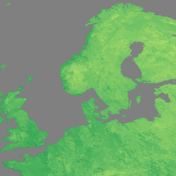
var dataset = ee.ImageCollection('NASA/VIIRS/002/VNP21A1N')\n .filter(ee.Filter.date('2022-11-01', '2022-12-01'));\n\nvar visualization = {\n bands: ['LST_1KM'],\n min: [150],\n max: [300],\n palette: [\n 'a50026',\n 'd73027',\n 'f46d43',\n 'fdae61',\n 'fee08b',\n 'ffffbf',\n 'd9ef8b',\n 'a6d96a',\n '66bd63',\n '1a9850',\n '006837',\n ]\n};\nMap.setCenter(41.2, 38.84, 3);\nMap.addLayer(dataset, visualization, 'LST');\n```\n[Open in Code Editor](https://code.earthengine.google.com/?scriptPath=Examples:Datasets/NASA/NASA_VIIRS_002_VNP21A1N) \n[VNP21A1N.002: Night Land Surface Temperature and Emissivity Daily 1km](/earth-engine/datasets/catalog/NASA_VIIRS_002_VNP21A1N) \nThe NASA Suomi National Polar-Orbiting Partnership (Suomi NPP) Visible Infrared Imaging Radiometer Suite (VIIRS) Land Surface Temperature and Emissivity (LST\\&E) Night Version 1 product (VNP21A1N) is compiled daily from nighttime Level 2 Gridded (L2G) intermediate products. The L2G process maps the daily VNP21 swath granules onto a sinusoidal MODIS grid ... \nNASA/VIIRS/002/VNP21A1N, climate,daily,land,nasa,night,noaa,surface,temperature,viirs \n2012-01-19T00:00:00Z/2025-08-30T00:00:00Z \n-90 -180 90 180 \nGoogle Earth Engine \nhttps://developers.google.com/earth-engine/datasets\n\n- [https://doi.org/10.5067/VIIRS/VNP21A1N.002](https://doi.org/https://doi.org/10.5067/VIIRS/VNP21A1N.002)\n- [https://doi.org/10.5067/VIIRS/VNP21A1N.002](https://doi.org/https://developers.google.com/earth-engine/datasets/catalog/NASA_VIIRS_002_VNP21A1N)"]]