Ocean Near-Surface Atmospheric Properties 데이터 세트는 NOAA Ocean Surface Bundle (OSB)의 일부이며, 얼음이 없는 해양 표면의 기온, 풍속, 비습에 관한 고품질 기후 데이터 기록(CDR)을 제공합니다.
이러한 대기 속성은 신경망을 사용하여 국방 기상 위성 프로그램 (DMSP) 우주선의 특수 센서 마이크로파/이미저 (SSM/I) 및 특수 센서 마이크로파/이미저 사운더 (SSMIS)의 밝기 온도 데이터를 기반으로 계산됩니다.
대역
픽셀 크기 27830미터
대역
이름
단위
최소
최대
픽셀 크기
설명
air_temperature
°C
-42.16*
42.77*
미터
10m 지점의 기온
specific_humidity
g/kg
0.07*
37.06*
미터
10m에서의 특정 습도
wind_speed
m/s
0.13*
71.45*
미터
10m에서의 풍속
fill_missing_qc
미터
품질 관리 플래그
fill_missing_qc의 비트 마스크
비트 0~2: 품질 관리 플래그
0: 신경망의 픽셀 값
1: 사용되지 않는 플래그
2: 눈/얼음
3: 육지
4: 호수 위
5: 보간 실패
* 예상 최솟값 또는 최댓값
이용약관
이용약관
CDR의 NOAA CDR 프로그램 공식 배포 지점은 NOAA의 국립 기후 데이터 센터입니다. 이 센터는 대통령의 '공개 데이터 정책'에 관한 메모에 설명되어 있고 2013년 5월 9일의 행정 명령 '정부 정보의 새로운 기본값으로 공개 및 기계 판독 가능 설정'에 따라 미국의 공개 데이터 정책 및 관행을 준수하여 CDR 패키지 및 관련 정보에 대한 지속적이고 개방적인 액세스와 적극적인 데이터 관리를 제공합니다. 이러한 정책에 따라 CDR 데이터 세트는 독점적이지 않고 공개적으로 제공되며 사용에 제한이 없습니다. 자세한 내용은 NOAA의 CDR 데이터 세트, 알고리즘, 문서의 공정 사용 PDF를 참고하세요.
인용
인용:
Clayson, Carol Anne, Brown, Jeremiah, NOAA CDR Program (2016). NOAA
해양 표면 번들 (OSB) 기후 데이터 기록(CDR) 근표면 대기 속성, 버전 2. [사용된 하위 집합을 나타냅니다]. NOAA National ClimaticData Center. doi:10.7289/V55T3HH0.
Ocean Near-Surface Atmospheric Properties 데이터 세트는 NOAA Ocean Surface Bundle (OSB)의 일부이며, 얼음이 없는 해양 표면의 기온, 풍속, 비습에 관한 고품질 Climate Data Record (CDR)를 제공합니다. 이러한 대기 속성은 특수 센서의 밝기 온도 데이터를 기반으로 계산됩니다.
[null,null,[],[[["\u003cp\u003eThe NOAA Ocean Near-Surface Atmospheric Properties dataset provides hourly data on air temperature, wind speed, and specific humidity over ice-free oceans from 1988 to 2021.\u003c/p\u003e\n"],["\u003cp\u003eThe dataset, part of the NOAA Ocean Surface Bundle (OSB), is derived from satellite measurements using a neural network to calculate atmospheric properties.\u003c/p\u003e\n"],["\u003cp\u003eData is available at a resolution of 27830 meters and includes quality control flags to identify potentially problematic pixels.\u003c/p\u003e\n"],["\u003cp\u003eThis Climate Data Record (CDR) is freely available for research and non-commercial use, with no restrictions on its application.\u003c/p\u003e\n"],["\u003cp\u003eThe dataset is hosted on Google Earth Engine and can be accessed and analyzed using their platform and tools.\u003c/p\u003e\n"]]],["The NOAA Ocean Near-Surface Atmospheric Properties dataset (1988-2021) offers a Climate Data Record (CDR) of air temperature, wind speed, and specific humidity over ice-free oceans, available at a 3-hour cadence. Data is derived from Special Sensor Microwave/Imager (SSM/I) brightness temperature data using a neural network. The dataset's spatial resolution is 27830 meters. The NOAA CDR Program ensures open, unrestricted access to these datasets.\n"],null,["# NOAA CDR: Ocean Near-Surface Atmospheric Properties, Version 2\n\nDataset Availability\n: 1988-01-01T00:00:00Z--2021-08-31T00:00:00Z\n\nDataset Provider\n:\n\n\n [NOAA](https://www.ncdc.noaa.gov/cdr/atmospheric/ocean-near-surface-atmospheric-properties)\n\nCadence\n: 3 Hours\n\nTags\n:\n [atmospheric](/earth-engine/datasets/tags/atmospheric) [cdr](/earth-engine/datasets/tags/cdr) [hourly](/earth-engine/datasets/tags/hourly) [humidity](/earth-engine/datasets/tags/humidity) [noaa](/earth-engine/datasets/tags/noaa) [ocean](/earth-engine/datasets/tags/ocean) [oceans](/earth-engine/datasets/tags/oceans) [osb](/earth-engine/datasets/tags/osb) [wind](/earth-engine/datasets/tags/wind) \nair-temperature \n\n#### Description\n\nThe Ocean Near-Surface Atmospheric Properties dataset is part of the NOAA\nOcean Surface Bundle (OSB) and provides a high quality Climate Data Record\n(CDR) of air temperature, wind speed, and specific humidity over ice-free\nocean surfaces.\n\nThese atmospheric properties are calculated based on brightness temperature\ndata from the Special Sensor Microwave/Imager (SSM/I) and the Special Sensor\nMicrowave/Imager Sounder (SSMIS) on the Defense Meteorological Satellite\nProgram (DMSP) spacecraft, using a neural network.\n\n### Bands\n\n\n**Pixel Size**\n\n27830 meters\n\n**Bands**\n\n| Name | Units | Min | Max | Pixel Size | Description |\n|---------------------|-------|----------|---------|------------|--------------------------|---|---|---|---|---|---|---|---|---|---|---|---|---|---|---|---|---|---|---|---|---|---|---|---|---|---|---|---|---|---|---|---|---|---|---|---|---|---|---|---|---|---|---|---|---|---|---|---|---|---|---|---|---|---|---|---|---|---|---|---|---|---|---|---|---|---|---|---|---|---|---|---|---|---|---|---|---|---|---|---|---|---|---|---|---|---|---|---|---|---|---|---|---|---|\n| `air_temperature` | °C | -42.16\\* | 42.77\\* | meters | Air temperature at 10m |\n| `specific_humidity` | g/kg | 0.07\\* | 37.06\\* | meters | Specific humidity at 10m |\n| `wind_speed` | m/s | 0.13\\* | 71.45\\* | meters | Wind speed at 10m |\n| `fill_missing_qc` | | | | meters | Quality control flags |\n| Bitmask for fill_missing_qc - Bits 0-2: Quality control flags - 0: Pixel values from neural network - 1: Unused flag - 2: Snow/ice - 3: Over land - 4: Over lake - 5: Failed interpolation ||||||||||||||||||||||||||||||||||||||||||||||||||||||||||||||||||||||||||||||||||||||||||||||||||||\n\n\\* estimated min or max value\n\n### Terms of Use\n\n**Terms of Use**\n\nThe NOAA CDR Program's official distribution point for CDRs is NOAA's\nNational Climatic Data Center which provides sustained, open access and\nactive data management of the CDR packages and related information in\nkeeping with the United States' open data policies and practices as\ndescribed in the President's Memorandum on \"Open Data Policy\" and pursuant\nto the Executive Order of May 9, 2013, \"Making Open and Machine Readable\nthe New Default for Government Information\". In line with these policies,\nthe CDR data sets are nonproprietary, publicly available, and no\nrestrictions are placed upon their use. For more information, see the\n[Fair Use of NOAA's CDR Data Sets, Algorithms and Documentation](https://www1.ncdc.noaa.gov/pub/data/sds/cdr/CDRs/Aerosol_Optical_Thickness/UseAgreement_01B-04.pdf)\npdf.\n\n### Citations\n\nCitations:\n\n- Clayson, Carol Anne, Brown, Jeremiah, and NOAA CDR Program (2016). NOAA\n Climate Data Record Ocean Surface Bundle (OSB) Climate Data Record\n (CDR) of Near-surface Atmospheric Properties, Version 2. \\[indicate subset\n used\\]. NOAA National ClimaticData Center. [doi:10.7289/V55T3HH0](https://doi.org/10.7289/V55T3HH0).\n\n### DOIs\n\n- \u003chttps://doi.org/10.7289/V55T3HH0\u003e\n\n### Explore with Earth Engine\n\n| **Important:** Earth Engine is a platform for petabyte-scale scientific analysis and visualization of geospatial datasets, both for public benefit and for business and government users. Earth Engine is free to use for research, education, and nonprofit use. To get started, please [register for Earth Engine access.](https://console.cloud.google.com/earth-engine)\n\n### Code Editor (JavaScript)\n\n```javascript\n
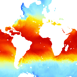
var dataset = ee.ImageCollection('NOAA/CDR/ATMOS_NEAR_SURFACE/V2')\n .filter(ee.Filter.date('2017-05-01', '2017-05-02'));\nvar airTemperature = dataset.select('air_temperature');\nvar airTemperatureVis = {\n min: 0.0,\n max: 30.0,\n palette: [\n '040274', '040281', '0502a3', '0502b8', '0502ce', '0502e6',\n '0602ff', '235cb1', '307ef3', '269db1', '30c8e2', '32d3ef',\n '3be285', '3ff38f', '86e26f', '3ae237', 'b5e22e', 'd6e21f',\n 'fff705', 'ffd611', 'ffb613', 'ff8b13', 'ff6e08', 'ff500d',\n 'ff0000', 'de0101', 'c21301', 'a71001', '911003'\n ],\n};\nMap.setCenter(28.3, -28.1, 1);\nMap.addLayer(airTemperature, airTemperatureVis, 'Air Temperature');\n```\n[Open in Code Editor](https://code.earthengine.google.com/?scriptPath=Examples:Datasets/NOAA/NOAA_CDR_ATMOS_NEAR_SURFACE_V2) \n[NOAA CDR: Ocean Near-Surface Atmospheric Properties, Version 2](/earth-engine/datasets/catalog/NOAA_CDR_ATMOS_NEAR_SURFACE_V2) \nThe Ocean Near-Surface Atmospheric Properties dataset is part of the NOAA Ocean Surface Bundle (OSB) and provides a high quality Climate Data Record (CDR) of air temperature, wind speed, and specific humidity over ice-free ocean surfaces. These atmospheric properties are calculated based on brightness temperature data from the Special Sensor ... \nNOAA/CDR/ATMOS_NEAR_SURFACE/V2, atmospheric,cdr,hourly,humidity,noaa,ocean,oceans,osb,wind \n1988-01-01T00:00:00Z/2021-08-31T00:00:00Z \n-90 -180 90 180 \nGoogle Earth Engine \nhttps://developers.google.com/earth-engine/datasets\n\n- [https://doi.org/10.7289/V55T3HH0](https://doi.org/https://www.ncdc.noaa.gov/cdr/atmospheric/ocean-near-surface-atmospheric-properties)\n- [https://doi.org/10.7289/V55T3HH0](https://doi.org/https://developers.google.com/earth-engine/datasets/catalog/NOAA_CDR_ATMOS_NEAR_SURFACE_V2)"]]