- 데이터 세트 제공
- 1979-01-01T00:00:00Z–2026-04-21T18:00:00Z
- 데이터 세트 출처
- NOAA NWS National Centers for Environmental Prediction (NCEP)
- 주기
- 6시간
- 태그
설명
국립 환경 예측 센터 (NCEP) 기후 예측 시스템 (CFS)은 지구의 대기, 해양, 육지, 해빙 간의 상호작용을 나타내는 완전 결합 모델입니다. CFS는 NCEP의 환경 모델링 센터 (EMC)에서 개발되었습니다. 운영 CFS는 2011년 3월 30일에 버전 2 (CFSv2)로 업그레이드되었습니다.
예측은 하루에 네 번 (0000, 0600, 1200, 1800 UTC) 초기화됩니다. 이 모델은 NCEP 기후 예측 시스템 재분석 (CFSR)을 만드는 데 사용된 모델과 동일하며 CFSv2 데이터 세트의 목적은 CFSR을 확장하는 것입니다. cdas1.t??z.sfluxgrbf06.grib2와 일치하는 파일에서 일부 밴드만 인제스트합니다.
CFS에 대한 자세한 내용은 CFS NOAA 사이트를 참고하세요.
대역
대역
픽셀 크기: 22,264m (모든 밴드)
| 이름 | 단위 | 최소 | 최대 | 픽셀 크기 | 설명 |
|---|---|---|---|---|---|
Downward_Long-Wave_Radp_Flux_surface_6_Hour_Average |
W/m^2 | 41.76* | 532.67* | 22264미터 | 지표면에서의 하향 장파 복사 플럭스, 6시간 평균 |
Downward_Short-Wave_Radiation_Flux_surface_6_Hour_Average |
W/m^2 | 0* | 1125.23* | 22264미터 | 표면에서의 하향 단파 복사 플럭스, 6시간 평균 |
Geopotential_height_surface |
gpm | -292* | 5938.65* | 22264미터 | 표면의 지오포텐셜 높이 |
Latent_heat_net_flux_surface_6_Hour_Average |
W/m^2 | -628* | 2,357* | 22264미터 | 표면에서의 잠열 순 유량, 6시간 평균 |
Maximum_specific_humidity_at_2m_height_above_ground_6_Hour_Interval |
질량 분율 | 0* | 0.1* | 22264미터 | 지상 2m의 최대 비습, 6시간 간격 |
Maximum_temperature_height_above_ground_6_Hour_Interval |
K | 189.8* | 334.89* | 22264미터 | 지상 2m의 최대 온도, 6시간 간격 2025년 10월 20일 18시 0분 0초에 단위가 켈빈에서 섭씨로 전환되었습니다. |
Minimum_specific_humidity_at_2m_height_above_ground_6_Hour_Interval |
질량 분율 | 0* | 0.02* | 22264미터 | 지상 2m의 최소 비습도, 6시간 간격 |
Minimum_temperature_height_above_ground_6_Hour_Interval |
K | 188.39* | 324.39* | 22264미터 | 지상 2m의 최소 온도, 6시간 간격 2025년 10월 20일 18시 0분 0초에 단위가 켈빈에서 섭씨로 전환되었습니다. |
Potential_Evaporation_Rate_surface_6_Hour_Average |
W/m^2 | -202* | 6277* | 22264미터 | 표면에서의 잠재 증발률, 6시간 평균 |
Precipitation_rate_surface_6_Hour_Average |
kg/m^2/s | 0* | 0.03* | 22264미터 | 지표면의 강수량, 6시간 평균 |
Pressure_surface |
Pa | 47,200* | 109180* | 22264미터 | 표면의 압력 |
Sensible_heat_net_flux_surface_6_Hour_Average |
W/m^2 | -2295* | 3112* | 22264미터 | 표면에서의 현열 순 플럭스, 6시간 평균 |
Specific_humidity_height_above_ground |
질량 분율 | 0* | 0.06* | 22264미터 | 지상 2m의 비습 |
Temperature_height_above_ground |
K | 188.96* | 328.68* | 22264미터 | 지상 2m 높이의 온도입니다. 2025년 10월 20일 18시 0분 0초에 단위가 켈빈에서 섭씨로 전환되었습니다. |
u-component_of_wind_height_above_ground |
m/s | -57.2* | 57.99* | 22264미터 | 지상 10m 위의 바람의 U 구성요소 |
Upward_Long-Wave_Radp_Flux_surface_6_Hour_Average |
W/m^2 | 59* | 757* | 22264미터 | 지표면에서의 상향 장파 복사 플럭스, 6시간 평균 |
Upward_Short-Wave_Radiation_Flux_surface_6_Hour_Average |
W/m^2 | 0* | 812* | 22264미터 | 지표면에서의 상향 단파 복사 플럭스, 6시간 평균 |
v-component_of_wind_height_above_ground |
m/s | -53.09* | 57.11* | 22264미터 | 지상 10m 위의 바람의 V 구성요소 |
Volumetric_Soil_Moisture_Content_depth_below_surface_layer_5_cm |
분수 | 0.02* | 1* | 22264미터 | 표면층 아래 5cm의 체적 토양 수분 함량 |
Volumetric_Soil_Moisture_Content_depth_below_surface_layer_25_cm |
분수 | 0.02* | 1* | 22264미터 | 표면층 아래 25cm의 체적 토양 수분 함량 |
Volumetric_Soil_Moisture_Content_depth_below_surface_layer_70_cm |
분수 | 0.02* | 1* | 22264미터 | 표면층 아래 70cm의 체적 토양 수분 함량 |
Volumetric_Soil_Moisture_Content_depth_below_surface_layer_150_cm |
분수 | 0.02* | 1* | 22264미터 | 표면층 아래 150cm의 체적 토양 수분 함량 |
이미지 속성
이미지 속성
| 이름 | 유형 | 설명 |
|---|---|---|
| end_hour | DOUBLE | 종료 시간 |
| start_hour | DOUBLE | 시작 시간 |
이용약관
이용약관
NOAA 데이터, 정보, 제품은 제공 방법에 관계없이 저작권이 적용되지 않으며 누구나 제한 없이 후속 사용할 수 있습니다. 입수한 후에는 법적으로 허용되는 모든 용도로 자유롭게 사용할 수 있습니다. 위의 데이터는 공개 도메인에 속하며 사용 및 배포에 제한 없이 제공됩니다. 자세한 내용은 NWS 면책 조항 사이트를 참고하세요.
인용
Saha, S., et al. 2011, 매일 업데이트됨. NCEP 기후 예측 시스템 버전 2 (CFSv2) 6시간 제품입니다. Research Data Archive at the National Center for Atmospheric Research, Computational and Information Systems Laboratory. https://doi.org/10.5065/D61C1TXF. dd mmm yyyy에 액세스함.
DOI
Earth Engine으로 탐색
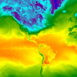
코드 편집기(JavaScript)
var dataset = ee.ImageCollection('NOAA/CFSV2/FOR6H')
                  .filter(ee.Filter.date('2018-03-01', '2018-03-14'));
var temperatureAboveGround = dataset.select('Temperature_height_above_ground');
var visParams = {
  min: 220.0,
  max: 310.0,
  palette: ['blue', 'purple', 'cyan', 'green', 'yellow', 'red'],
};
Map.setCenter(-88.6, 26.4, 1);
Map.addLayer(temperatureAboveGround, visParams, 'Temperature Above Ground');