- در دسترس بودن مجموعه دادهها
- ۱۹۹۶-۰۳-۱۶T۰۰:۰۰:۰۰Z–۲۰۱۱-۰۷-۳۱T۰۰:۰۰:۰۰Z
- تولیدکننده مجموعه داده
- گروه رصد زمین، موسسه سیاست عمومی پین، دانشکده معادن کلرادو
- برچسبها
توضیحات
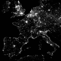
سامانه اسکن خطی عملیاتی (OLS) برنامه هواشناسی دفاعی (DMSP) قابلیت منحصر به فردی برای شناسایی منابع انتشار نور مرئی و فروسرخ نزدیک (VNIR) در شب دارد.
این مجموعه شامل تصاویر جهانی نورهای شبانه بدون اشباع حسگر است. این حسگر معمولاً در تنظیمات بهره بالا کار میکند تا امکان تشخیص ابرهای مهتابی را فراهم کند. با این حال، با کوانتیزاسیون شش بیتی و محدوده دینامیکی محدود، دادههای ثبت شده در هستههای روشن مراکز شهری اشباع میشوند. مجموعهای محدود از مشاهدات در روشنایی کم ماه به دست آمد که در آن بهره آشکارساز به طور قابل توجهی پایینتر از تنظیمات عملیاتی معمول آن (گاهی اوقات با ضریب ۱۰۰) تنظیم شده بود. دادههای پراکنده به دست آمده در تنظیمات بهره پایین با دادههای عملیاتی به دست آمده در تنظیمات بهره بالا ترکیب شدند تا مجموعهای از تصاویر جهانی نورهای شبانه بدون اشباع حسگر تولید شود. دادههای ماهوارههای مختلف ادغام و در محصول نهایی ترکیب شدند تا حداکثر پوشش به دست آید. برای اطلاعات بیشتر، به این فایل readme از ارائه دهنده مراجعه کنید.
پردازش تصویر و دادهها توسط مرکز ملی دادههای ژئوفیزیکی NOAA. دادههای DMSP توسط آژانس هواشناسی نیروی هوایی ایالات متحده جمعآوری شده است.
باندها
باندها
اندازه پیکسل: ۹۲۷.۶۷ متر (همه باندها)
| نام | حداقل | مکس | اندازه پیکسل | توضیحات |
|---|---|---|---|---|
avg_vis | 0* | ۶۰۶۰.۶* | ۹۲۷.۶۷ متر | میانگین اعداد باند دیجیتال از مشاهدات با تشخیص نور بدون ابر. |
cf_cvg | 0* | ۱۷۵* | ۹۲۷.۶۷ متر | پوششهای بدون ابر، تعداد کل مشاهداتی که در هر سلول شبکهای ۳۰ ثانیه قوسی قرار گرفتهاند. این تصویر میتواند برای شناسایی مناطقی با تعداد مشاهدات کم که کیفیت آنها کاهش یافته است، استفاده شود. |
شرایط استفاده
شرایط استفاده
دادهها، اطلاعات و محصولات NOAA، صرف نظر از روش ارائه، مشمول حق چاپ نیستند و هیچ محدودیتی در استفاده بعدی آنها توسط عموم وجود ندارد. پس از دریافت، میتوان از آنها به هر نحو قانونی استفاده کرد. دادههای فوق در مالکیت عمومی قرار دارند و بدون محدودیت در استفاده و توزیع ارائه میشوند.
با موتور زمین کاوش کنید
ویرایشگر کد (جاوااسکریپت)
var dataset = ee.ImageCollection('NOAA/DMSP-OLS/CALIBRATED_LIGHTS_V4')
                  .filter(ee.Filter.date('2010-01-01', '2010-12-31'));
var nighttimeLights = dataset.select('avg_vis');
var nighttimeLightsVis = {
  min: 3.0,
  max: 60.0,
};
Map.setCenter(7.82, 49.1, 4);
Map.addLayer(nighttimeLights, nighttimeLightsVis, 'Nighttime Lights');