- Dostępność zbioru danych
- 1996-03-16T00:00:00Z–2011-07-31T00:00:00Z
- Dostawca zbioru danych
- Earth Observation Group, Payne Institute for Public Policy, Colorado School of Mines
- Tagi
Opis
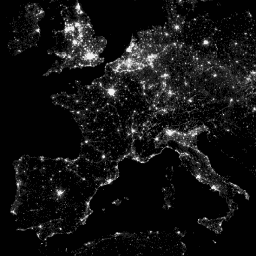
System Operational Line-Scan System (OLS) w ramach programu Defense Meteorological Program (DMSP) ma unikalną zdolność wykrywania w nocy źródeł emisji w zakresie widzialnym i bliskiej podczerwieni (VNIR).
Ta kolekcja zawiera obrazy globalnych świateł nocnych bez nasycenia czujnika. Czujnik jest zwykle używany w ustawieniu wysokiego wzmocnienia, aby umożliwić wykrywanie chmur oświetlonych przez księżyc. Jednak w przypadku 6-bitowej kwantyzacji i ograniczonego zakresu dynamicznego zarejestrowane dane są nasycone w jasnych centrach miast. Uzyskano ograniczony zestaw obserwacji przy niskim oświetleniu Księżyca, w których wzmocnienie detektora było znacznie niższe niż w typowych warunkach pracy (czasami nawet 100 razy). Rzadkie dane uzyskane przy ustawieniach niskiego wzmocnienia zostały połączone z danymi operacyjnymi uzyskanymi przy ustawieniach wysokiego wzmocnienia, aby utworzyć zestaw globalnych zdjęć nocnych świateł bez nasycenia czujnika. Dane z różnych satelitów zostały połączone i zmieszane w produkt końcowy, aby uzyskać maksymalny zasięg. Więcej informacji znajdziesz w pliku README dostawcy.
Przetwarzanie obrazów i danych przez National Geophysical Data Center NOAA. Dane DMSP zebrane przez US Air Force Weather Agency.
Pasma
Rozmiar piksela
927,67 m
Pasma
| Nazwa | Minimum | Maks. | Rozmiar piksela | Opis |
|---|---|---|---|---|
avg_vis |
0* | 6060,6* | metry | Średnie wartości pasm cyfrowych z obserwacji z wykrywaniem światła bez chmur. |
cf_cvg |
0* | 175* | metry | Pokrycie bez chmur, czyli łączna liczba obserwacji, które zostały uwzględnione w każdej komórce siatki o rozmiarze 30 sekund łuku. Ten obraz może służyć do identyfikowania obszarów o niskiej liczbie obserwacji, w których jakość jest obniżona. |
Warunki korzystania z usługi
Warunki korzystania z usługi
Dane, informacje i produkty NOAA, niezależnie od metody dostawy, nie podlegają ochronie prawem autorskim i nie podlegają ograniczeniom w zakresie ich późniejszego wykorzystania przez opinię publiczną. Po uzyskaniu można je wykorzystywać w dowolny zgodny z prawem sposób. Powyższe dane są dostępne publicznie i udostępniane bez ograniczeń dotyczących ich wykorzystania i dystrybucji.
Odkrywanie za pomocą Earth Engine
Edytor kodu (JavaScript)
var dataset = ee.ImageCollection('NOAA/DMSP-OLS/CALIBRATED_LIGHTS_V4')
                  .filter(ee.Filter.date('2010-01-01', '2010-12-31'));
var nighttimeLights = dataset.select('avg_vis');
var nighttimeLightsVis = {
  min: 3.0,
  max: 60.0,
};
Map.setCenter(7.82, 49.1, 4);
Map.addLayer(nighttimeLights, nighttimeLightsVis, 'Nighttime Lights');