-
2000 Greenland Mosaic - Greenland Ice Mapping Project (GIMP)
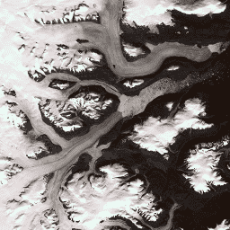
Ten zbiór danych zawiera kompletną mozaikę obrazów pokrywy lodowej Grenlandii o rozdzielczości 15 m, utworzoną na podstawie zdjęć Landsat 7 ETM+ i RADARSAT-1 SAR z lat 1999–2002. Metody te obejmują połączenie maskowania chmur na obrazach, wyostrzania panchromatycznego, próbkowania i zmiany rozmiaru obrazów… arktyka gimp grenlandia zdjęcia nasa polarne -
ASTER L1T Radiance

Uwaga: z powodu problemów technicznych z instrumentem ASTER występuje luka w zbieraniu danych w okresie od 28 listopada 2024 r. do 16 stycznia 2025 r. Więcej informacji znajdziesz w ogłoszeniu USGS. Zaawansowany radiometr do pomiaru emisji termicznej i odbicia w przestrzeni kosmicznej (ASTER) to wielospektralny system obrazowania, który … aster zdjęcia nasa nir radiance zdjęcia-satelitarne -
Zbiór danych dotyczących zdjęć lasów w Brazylii w 2008 roku: analityczna mapa podstawowa

Ten zbiór danych zawiera wielospektralną (zieloną, czerwoną i bliską podczerwieni) mapę podstawową Brazylii o rozdzielczości do 10 m, która została utworzona głównie w 2008 r. i ma wspierać wdrażanie brazylijskiego kodeksu leśnego. Mozaika jest tworzona na podstawie danych satelitarnych SPOT 2, 4 i 5. Jest to obraz o wyższej rozdzielczości… brazil forest-code google imagery multispectral satellite-imagery -
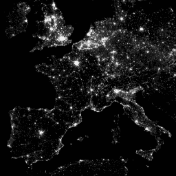
CCNL: Consistent and Corrected Nighttime Light Dataset from DMSP-OLS (1992-2013) v1
Zbiór danych Consistent and Corrected Nighttime Lights (CCNL) to przetworzona wersja danych z systemu Operational Line-Scan System (OLS) w wersji 4 w ramach programu Defense Meteorological Program (DMSP). Aby ograniczyć wpływ niespójności międzyrocznej, nasycenia i efektów rozkwitu oraz poprawić jakość danych, zastosowano szereg metod. dmsp eog imagery lights nighttime ols -
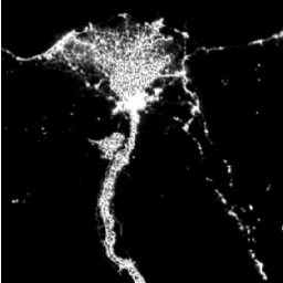
DMSP OLS: Global Radiance-Calibrated Nighttime Lights Version 4, Defense Meteorological Program Operational Linescan System

System Operational Line-Scan System (OLS) w ramach programu Defense Meteorological Program (DMSP) ma unikalną zdolność wykrywania w nocy źródeł emisji w zakresie widzialnym i bliskiej podczerwieni (VNIR). Ta kolekcja zawiera globalne zdjęcia nocne bez nasycenia czujnika. Czujnik jest zwykle obsługiwany przy ustawieniu wysokiego wzmocnienia, aby umożliwić … dmsp eog imagery lights nighttime ols -
DMSP OLS: Nighttime Lights Time Series Version 4, Defense Meteorological Program Operational Linescan System
System Operational Line-Scan System (OLS) w ramach programu Defense Meteorological Program (DMSP) ma unikalną zdolność wykrywania w nocy źródeł emisji w zakresie widzialnym i bliskiej podczerwieni (VNIR). Wersja 4 szeregu czasowego DMSP-OLS Nighttime Lights składa się z kompozytów bez chmur utworzonych przy użyciu wszystkich dostępnych zarchiwizowanych danych DMSP-OLS o płynnej rozdzielczości… dmsp eog imagery lights nighttime ols -
NAIP: National Agriculture Imagery Program
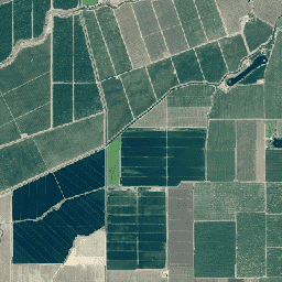
Program National Agriculture Imagery Program (NAIP) pozyskuje zdjęcia lotnicze w okresie wegetacyjnym w Stanach Zjednoczonych kontynentalnych. Projekty NAIP są realizowane co roku w zależności od dostępnych środków i cyklu pozyskiwania zdjęć. Od 2003 r. dane NAIP były pozyskiwane w 5-letnim cyklu. 2008 r. był… agriculture highres imagery orthophotos usda -
Zdjęcia panchromatyczne SPOT o rozdzielczości 5–10 m, Brazylia

Ta kolekcja zawiera surowe pasma panchromatyczne (PAN) z satelitów SPOT 2, 4 i 5 dla Brazylii z okresu około 2008 r. Czujnik panchromatyczny zapewnia najwyższą natywną rozdzielczość przestrzenną misji, rejestrując światło w szerokim spektrum widzialnym (0,51–0,73 µm w przypadku SPOT 2, 0,61–0,68 µm w przypadku … brazil forest-code google imagery satellite-imagery spot
Datasets tagged imagery in Earth Engine
[null,null,[],[],[]]