-
2000 Greenland Mosaic - Greenland Ice Mapping Project (GIMP)
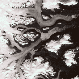
Ten zbiór danych zawiera kompletną mozaikę obrazów pokrywy lodowej Grenlandii o rozdzielczości 15 m, utworzoną na podstawie zdjęć Landsat 7 ETM+ i RADARSAT-1 SAR z lat 1999–2002. Metody te obejmują połączenie maskowania chmur na obrazach, wyostrzania panchromatycznego, próbkowania i zmiany rozmiaru obrazów… arktyka gimp grenlandia zdjęcia nasa polarne -
Grenlandia DEM - Greenland Mapping Project (GIMP)
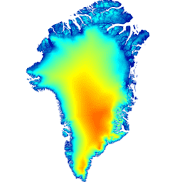
Ten cyfrowy model wysokościowy (DEM) został utworzony na podstawie połączenia modeli DEM ASTER i SPOT-5 dla obrzeży i krawędzi pokrywy lodowej (tj. poniżej linii równowagi) na południe od około 82,5°N oraz fotoklinometrii AVHRR we wnętrzu pokrywy lodowej i na dalekiej północy (Scambos i … arktyka wysokość-topografia gimp grenlandia nasa polarne -
Greenland Ice & Ocean Mask - Greenland Mapping Project (GIMP)
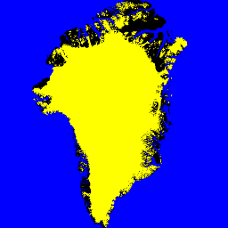
Ten zbiór danych zawiera pełne maski klasyfikacji lodu lądowego i oceanu w rozdzielczości 15 m dla pokrywy lodowej Grenlandii. Pokrywa lodowa została zmapowana na podstawie ortorektyfikowanych zdjęć panchromatycznych (pasmo 8) z instrumentu Enhanced Thematic Mapper Plus (ETM+) na satelicie Landsat 7, które są rozpowszechniane przez USGS, oraz … arktyka kriosfera gimp grenlandia lód nasa -
MEaSUREs Greenland Ice Velocity: Selected Glacier Site Velocity Maps from Optical Images Version 2
Ten zbiór danych, będący częścią programu NASA Making Earth System Data Records for Use in Research Environments (MEaSUREs), zawiera mapy średnich miesięcznych prędkości dla wybranych obszarów ujścia lodowców. Mapy są generowane na podstawie śledzenia widocznych obiektów między parami obrazów optycznych uzyskanych przez satelitę Landsat… arktyka kriosfera gimp grenlandia lód nasa
Datasets tagged greenland in Earth Engine
[null,null,[],[],[]]