- Dostępność zbioru danych
- 1999-06-30T00:00:00Z–2002-09-04T00:00:00Z
- Dostawca zbioru danych
- Ośrodek NASA NSIDC DAAC w CIRES
- Tagi
Opis
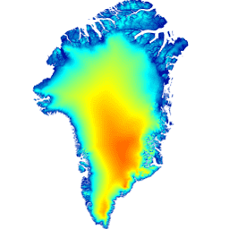
Ten cyfrowy model terenu (DEM) został utworzony na podstawie połączenia modeli DEM ASTER i SPOT-5 dla obrzeży i krawędzi pokrywy lodowej (tj. poniżej linii równowagi) na południe od około 82,5°N oraz fotoklinometrii AVHRR we wnętrzu pokrywy lodowej i na dalekiej północy (Scambos i Haran, 2002).
Modele DEM SPOT-5 zostały opracowane i rozpowszechnione w ramach projektu Spot5 stereoscopic survey of Polar Ice: Reference Images & Topographies (SPIRIT) (Korona i in., 2009). Powierzchnie oceanów zostały zamaskowane za pomocą maski klasyfikacji terenu GIMP i zastąpione średnią wysokością powierzchni morza CNES CLS11 (Schaeffer i in., 2012).
Uwaga
- Wszystkie dane dotyczące wysokości terenu są zarejestrowane w poziomie i pionie w odniesieniu do średnich wysokości ICESat z lat 2003–2009, dlatego DEM ma nominalną datę 2007 r. Należy jednak zachować ostrożność podczas korzystania z DEM na obszarach, na których zachodzą szybkie zmiany, takich jak duże lodowce wypływowe na południe od 70°0N.
- Model DEM ma rozdzielczość 30 m, chociaż „prawdziwa” rozdzielczość modelu DEM będzie się różnić od 40 m na obszarach pokrytych przez SPOT-5 (patrz Korona i in. 2009) do 500 m na obszarach fotoklinometrii.
- Błąd walidacji średniej kwadratowej na całej powierzchni pokrywy lodowej w stosunku do danych z satelity ICESat wynosi ±10 m, przy czym na większości powierzchni lodowych jest bliski ±1 m, a na obszarach o dużych różnicach wysokości – ±30 m.
Pasma
Pasma
Rozmiar piksela: 30 m (wszystkie pasma)
| Nazwa | Jednostki | Rozmiar piksela | Opis |
|---|---|---|---|
elevation |
m | 30 metrów | Wysokość |
Warunki korzystania z usługi
Warunki korzystania z usługi
Warunkiem korzystania z tych danych jest podanie cytatu dotyczącego tego zbioru danych.
Cytaty
Howat, I.M., A. Negrete, B.E. Smith, 2014, The Greenland Ice Mapping Project (GIMP) land classification and surface elevation datasets, The Cryosphere, 8, 1509-1518, doi:10.5194/tc-8-1509-2014 artykuł w formacie PDF
DOI
Odkrywaj za pomocą Earth Engine
Edytor kodu (JavaScript)
var dataset = ee.Image('OSU/GIMP/DEM');
var elevation = dataset.select('elevation');
var elevationVis = {
  min: 0.0,
  max: 2000.0,
};
Map.setCenter(-41.0, 76.0, 4);
Map.addLayer(elevation, elevationVis, 'Elevation');