- Dostępność zbioru danych
- 1999-06-30T00:00:00Z–2002-09-04T00:00:00Z
- Dostawca zbioru danych
- NASA NSIDC DAAC at CIRES
- Tagi
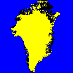
Opis
Ten zbiór danych zawiera pełne maski klasyfikacji lodu lądowego i oceanu na obszarze pokrywy lodowej Grenlandii w rozdzielczości 15 m. Pokrywa lodowa została zmapowana na podstawie połączenia ortorektyfikowanych obrazów panchromatycznych (pasmo 8) z instrumentu Enhanced Thematic Mapper Plus (ETM+) na satelicie Landsat 7, rozpowszechnianych przez USGS, oraz obrazów amplitudy z radaru z syntetyczną aperturą (SAR) na satelicie RADARSAT-1, wyprodukowanych i rozpowszechnianych przez I. Joughin z Laboratorium Fizyki Stosowanej Uniwersytetu Waszyngtońskiego.
Zdjęcia Landsat zostały wykonane w okresie od lipca do września w latach 1999, 2000 i 2001 (głównie w 2000 r.), a zdjęcia RADARSAT – jesienią 2000 r.
Pasma
Rozmiar piksela
15 metrów
Pasma
| Nazwa | Rozmiar piksela | Opis |
|---|---|---|
ocean_mask |
metry | Maska oceanu |
ice_mask |
metry | Maska lodowa |
Tabela klas ocean_mask
| Wartość | Kolor | Opis |
|---|---|---|
| 0 | #000000 | wszystkie inne tereny, |
| 1 | #0000ff | ocean |
Tabela klas ice_mask
| Wartość | Kolor | Opis |
|---|---|---|
| 0 | #000000 | nie jest lodem lodowcowym, |
| 1 | #ffffff | lód lodowcowy, |
Warunki korzystania z usługi
Warunki korzystania z usługi
Warunkiem korzystania z tych danych jest podanie cytatu z tego zbioru danych.
Cytaty
Howat, I.M., A. Negrete, B.E. Smith, 2014, The Greenland Ice Mapping Project (GIMP) land classification and surface elevation datasets, The Cryosphere, 8, 1509-1518, doi:10.5194/tc-8-1509-2014 artykuł w formacie PDF
DOI
Odkrywanie za pomocą Earth Engine
Edytor kodu (JavaScript)
var dataset = ee.Image('OSU/GIMP/2000_ICE_OCEAN_MASK');
var oceanAndIceMaskVis = {
  min: 0.0,
  max: 1.0,
  bands: ['ice_mask', 'ice_mask', 'ocean_mask'],
};
Map.setCenter(-41.0, 74.0, 4);
Map.addLayer(dataset, oceanAndIceMaskVis, 'Ocean and Ice Mask');