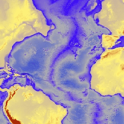
ETOPO1은 육지 지형과 해양 지형을 통합한 지구 표면의 1분 전역 지형 모델입니다. 이 모델은 수많은 글로벌 및 지역 데이터 세트를 기반으로 구축되었습니다. 여기에는 ice_surface와 bedrock이라는 두 개의 고도 대역이 포함되어 있습니다.
대역
Pixel Size 1855 meters
대역
이름
단위
최소
최대
픽셀 크기
설명
bedrock
m
-10898*
8271*
미터
지상 및 남극과 그린란드 빙상의 기저부의 고도
ice_surface
m
-10898*
8271*
미터
지상 및 남극과 그린란드 빙상의 상단 고도
* 예상 최솟값 또는 최댓값
이용약관
이용약관
ETOPO1 또는 퍼블릭 도메인에 있는 기타 NOAA 제품을 사용하기 위해 서면 허가를 받을 필요는 없으며, 사용료도 없습니다. NCEI를 출처로 인용하기만 하면 됩니다.
인용
인용:
Amante, C. and B. W. Eakins, ETOPO1 1 Arc-Minute Global Relief
Model: Procedures, Data Sources and Analysis. NOAA Technical Memorandum
NESDIS NGDC-24, 19 pp, March 2009.
[null,null,[],[[["\u003cp\u003eETOPO1 provides a 1 arc-minute global relief model integrating land topography and ocean bathymetry at a resolution of 1855 meters.\u003c/p\u003e\n"],["\u003cp\u003eThis dataset includes two elevation bands: bedrock elevation and ice surface elevation.\u003c/p\u003e\n"],["\u003cp\u003eIt is freely available for use with attribution to NCEI.\u003c/p\u003e\n"],["\u003cp\u003eETOPO1 is accessible through Google Earth Engine for analysis and visualization.\u003c/p\u003e\n"],["\u003cp\u003eNOAA is the provider of this public domain dataset.\u003c/p\u003e\n"]]],["The NOAA ETOPO1 dataset, available from 2008-08-01, provides a 1 arc-minute global relief model integrating land topography and ocean bathymetry. It includes `bedrock` and `ice_surface` elevation bands, each with a pixel size of 1855 meters. The dataset, accessible via Google Earth Engine using `ee.Image(\"NOAA/NGDC/ETOPO1\")`, is free to use with proper citation of NCEI as the source and is built from multiple global and regional datasets.\n"],null,["# ETOPO1: Global 1 Arc-Minute Elevation\n\nDataset Availability\n: 2008-08-01T00:00:00Z--2008-08-01T00:00:00Z\n\nDataset Provider\n:\n\n\n [NOAA](https://www.ngdc.noaa.gov/mgg/global/global.html)\n\nTags\n:\n[bedrock](/earth-engine/datasets/tags/bedrock) [dem](/earth-engine/datasets/tags/dem) [elevation](/earth-engine/datasets/tags/elevation) [elevation-topography](/earth-engine/datasets/tags/elevation-topography) [geophysical](/earth-engine/datasets/tags/geophysical) [ice](/earth-engine/datasets/tags/ice) [noaa](/earth-engine/datasets/tags/noaa) [topography](/earth-engine/datasets/tags/topography) \n\n#### Description\n\nETOPO1 is a 1 arc-minute global relief model of Earth''s\nsurface that integrates land topography and ocean bathymetry. It\nwas built from numerous global and regional data sets. It contains\ntwo elevation bands: ice_surface and bedrock.\n\n### Bands\n\n\n**Pixel Size**\n\n1855 meters\n\n**Bands**\n\n| Name | Units | Min | Max | Pixel Size | Description |\n|---------------|-------|----------|--------|------------|-------------------------------------------------------------------------------------|\n| `bedrock` | m | -10898\\* | 8271\\* | meters | Elevation at ground level and at the base of the Antarctic and Greenland ice sheets |\n| `ice_surface` | m | -10898\\* | 8271\\* | meters | Elevation at ground level and at the top of the Antarctic and Greenland ice sheets |\n\n\\* estimated min or max value\n\n### Terms of Use\n\n**Terms of Use**\n\nIt is not necessary to obtain written permission to\nuse ETOPO1 or other NOAA products that are in the public domain,\nnor are there any fees for using them. We ask only that you cite\nNCEI as source.\n\n### Citations\n\nCitations:\n\n- Amante, C. and B. W. Eakins, ETOPO1 1 Arc-Minute Global Relief\n Model: Procedures, Data Sources and Analysis. NOAA Technical Memorandum\n NESDIS NGDC-24, 19 pp, March 2009.\n\n### DOIs\n\n- \u003chttps://doi.org/10.7289/V5C8276M\u003e\n\n### Explore with Earth Engine\n\n| **Important:** Earth Engine is a platform for petabyte-scale scientific analysis and visualization of geospatial datasets, both for public benefit and for business and government users. Earth Engine is free to use for research, education, and nonprofit use. To get started, please [register for Earth Engine access.](https://console.cloud.google.com/earth-engine)\n\n### Code Editor (JavaScript)\n\n```javascript\nvar dataset = ee.Image('NOAA/NGDC/ETOPO1');\nvar elevation = dataset.select('bedrock');\nvar elevationVis = {\n min: -7000.0,\n max: 3000.0,\n palette: ['011de2', 'afafaf', '3603ff', 'fff477', 'b42109'],\n};\nMap.setCenter(-37.62, 25.8, 2);\nMap.addLayer(elevation, elevationVis, 'Elevation');\n```\n[Open in Code Editor](https://code.earthengine.google.com/?scriptPath=Examples:Datasets/NOAA/NOAA_NGDC_ETOPO1) \n[ETOPO1: Global 1 Arc-Minute Elevation](/earth-engine/datasets/catalog/NOAA_NGDC_ETOPO1) \nETOPO1 is a 1 arc-minute global relief model of Earth''s surface that integrates land topography and ocean bathymetry. It was built from numerous global and regional data sets. It contains two elevation bands: ice_surface and bedrock. \nNOAA/NGDC/ETOPO1, bedrock,dem,elevation,elevation-topography,geophysical,ice,noaa,topography \n2008-08-01T00:00:00Z/2008-08-01T00:00:00Z \n-90 -180 90 180 \nGoogle Earth Engine \nhttps://developers.google.com/earth-engine/datasets\n\n- [https://doi.org/10.7289/V5C8276M](https://doi.org/https://www.ngdc.noaa.gov/mgg/global/global.html)\n- [https://doi.org/10.7289/V5C8276M](https://doi.org/https://developers.google.com/earth-engine/datasets/catalog/NOAA_NGDC_ETOPO1)"]]