-
ETOPO1: 전역 1분 고도
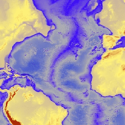
ETOPO1은 육지 지형과 해양 수심을 통합하는 지구 표면의 1분 전역 지형 모델입니다. 수많은 전역 및 리전 데이터 세트에서 빌드되었습니다. ice_surface 및 bedrock의 두 고도 밴드가 포함되어 있습니다. 기반암 dem 고도 고도-지형 지구물리학적 얼음 -
iSDAsoil 기반암까지의 깊이
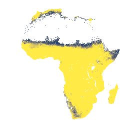
0~200cm 깊이에서 기반암까지의 깊이, 예측된 평균 및 표준 편차입니다. 데이터를 생성하는 데 사용된 잠재적 경작지 마스크로 인해 기반암까지의 깊이가 0cm인 노출된 암석의 많은 영역이 마스크 처리되어 표시되지 않습니다. 아프리카 기반암 isda 토양
Datasets tagged bedrock in Earth Engine
[null,null,[],[],["Two datasets describe bedrock characteristics. The first, iSDAsoil Depth to Bedrock, predicts the mean and standard deviation of bedrock depth in Africa from 0-200 cm. However, areas of exposed rock may be masked due to the data generation process. The second, ETOPO1, is a global relief model integrating land and ocean data, providing two elevation bands: ice surface and bedrock, with a one arc-minute resolution.\n"]]