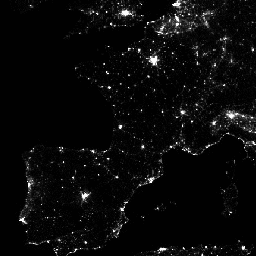
Среднемесячные составные изображения яркости с использованием ночных данных, полученных с помощью набора радиометров для визуализации в видимом инфракрасном диапазоне (VIIRS) в дневном/ночном диапазоне (DNB).
Поскольку эти данные формируются ежемесячно, во многих регионах земного шара невозможно получить качественные данные за этот месяц. Это может быть связано с облачностью, особенно в тропических регионах, или с солнечным освещением, как это происходит на полюсах в летние месяцы. Поэтому пользователям этих данных рекомендуется использовать канал «cf_cvg» и не предполагать, что нулевое значение в среднем изображении яркости означает отсутствие сияния.
Облачность определяется с помощью продукта VIIRS Cloud Mask (VCM). Кроме того, данные вблизи краев полосы обзора не включаются в составные данные (зоны агрегации 29–32). Версия 1 НЕ фильтруется для отсеивания источников света, таких как полярное сияние, пожары, суда и другие временные источники света. Такое разделение находится в стадии разработки и будет включено в более позднюю версию этого временного ряда. Также разрабатывается метод отделения источников света от фоновых (несветовых) значений.
Перед усреднением данные DNB фильтруются, чтобы исключить данные, на которые повлияли рассеянный свет, молнии, лунное освещение и облачность.
Группы
Размер пикселя 463,83 метра
Группы
Имя
Единицы
Мин.
Макс
Размер пикселя
Описание
avg_rad
нановатт/ср/см^2
-1,5*
340573*
метров
Средние значения яркости DNB.
cf_cvg
0*
58*
метров
Безоблачные покрытия; общее количество наблюдений, приходящееся на каждый пиксель. Этот диапазон можно использовать для выявления областей с малым количеством наблюдений, где качество снижается.
* расчетное минимальное или максимальное значение
Условия эксплуатации
Данные, информация и продукты Колорадской горной школы, независимо от способа доставки, не защищены авторским правом и не имеют ограничений на их последующее использование. После получения они могут быть использованы любым законным образом. Вышеуказанные данные находятся в открытом доступе и предоставляются без ограничений на использование и распространение.
Составные изображения среднего ежемесячного уровня яркости, полученные с использованием ночных данных, полученных с помощью комплекса инфракрасных радиометров видимого диапазона (VIIRS) в дневном/ночном диапазоне (DNB). Поскольку эти данные формируются ежемесячно, во многих регионах земного шара невозможно получить качественные данные за этот месяц. Это может быть связано с…
[null,null,[],[[["\u003cp\u003eThe NOAA/VIIRS/DNB/MONTHLY_V1/VCMCFG dataset provides monthly average radiance composite images using nighttime data from the Visible Infrared Imaging Radiometer Suite (VIIRS) Day/Night Band (DNB).\u003c/p\u003e\n"],["\u003cp\u003eThe dataset covers the period from April 2012 to July 2024 and has a resolution of 463.83 meters.\u003c/p\u003e\n"],["\u003cp\u003eIt includes two bands: 'avg_rad' representing average DNB radiance values and 'cf_cvg' indicating cloud-free coverages.\u003c/p\u003e\n"],["\u003cp\u003eUsers should utilize the 'cf_cvg' band to identify areas with potential quality issues due to cloud cover or solar illumination.\u003c/p\u003e\n"],["\u003cp\u003eThe data is provided by the Earth Observation Group at the Colorado School of Mines and is in the public domain without restrictions on use and distribution.\u003c/p\u003e\n"]]],["The dataset provides monthly nighttime radiance data from the VIIRS Day/Night Band (DNB), captured between April 1, 2012, and October 1, 2024. Data, with 463.83-meter pixel size, includes average radiance (`avg_rad`) and cloud-free coverage (`cf_cvg`) bands. It is advised to utilize the `cf_cvg` band due to varying data quality across regions and months. Data is filtered to exclude certain interferences, but not temporal lights, or separation from background. It is public domain and hosted by the Earth Observation Group.\n"],null,["# VIIRS Nighttime Day/Night Band Composites Version 1\n\nDataset Availability\n: 2012-04-01T00:00:00Z--2025-03-01T00:00:00Z\n\nDataset Provider\n:\n\n\n [Earth Observation Group, Payne Institute for Public Policy, Colorado School of Mines](https://eogdata.mines.edu/products/vnl/#monthly)\n\nCadence\n: 1 Month\n\nTags\n:\n[dnb](/earth-engine/datasets/tags/dnb) [eog](/earth-engine/datasets/tags/eog) [lights](/earth-engine/datasets/tags/lights) [monthly](/earth-engine/datasets/tags/monthly) [nighttime](/earth-engine/datasets/tags/nighttime) [noaa](/earth-engine/datasets/tags/noaa) [population](/earth-engine/datasets/tags/population) [viirs](/earth-engine/datasets/tags/viirs) [visible](/earth-engine/datasets/tags/visible) \n\n#### Description\n\nMonthly average radiance composite images using nighttime data from the\nVisible Infrared Imaging Radiometer Suite (VIIRS) Day/Night Band (DNB).\n\nAs these data are composited monthly, there are many areas of the globe\nwhere it is impossible to get good quality data coverage for that month.\nThis can be due to cloud cover, especially in the tropical regions, or due\nto solar illumination, as happens toward the poles in their respective\nsummer months. Therefore it is recommended that users of these data utilize\nthe 'cf_cvg' band and not assume a value of zero in the average radiance\nimage means that no lights were observed.\n\nCloud cover is determined using the VIIRS Cloud\nMask product (VCM). In addition, data near the edges of the swath are not\nincluded in the composites (aggregation zones 29-32). Version 1 has NOT\nbeen filtered to screen out lights from aurora, fires, boats, and other\ntemporal lights. This separation is under development and will be included\nin a later version of this time series. Also in development is a method to\nseparate lights from background (non-light) values.\n\nPrior to averaging, the DNB data is filtered to exclude data impacted by\nstray light, lightning, lunar illumination, and cloud-cover.\n\n### Bands\n\n\n**Pixel Size**\n\n463.83 meters\n\n**Bands**\n\n| Name | Units | Min | Max | Pixel Size | Description |\n|-----------|--------------------|--------|----------|------------|------------------------------------------------------------------------------------------------------------------------------------------------------------------------------------------|\n| `avg_rad` | nanoWatts/sr/cm\\^2 | -1.5\\* | 340573\\* | meters | Average DNB radiance values. |\n| `cf_cvg` | | 0\\* | 58\\* | meters | Cloud-free coverages; the total number of observations that went into each pixel. This band can be used to identify areas with low numbers of observations where the quality is reduced. |\n\n\\* estimated min or max value\n\n### Terms of Use\n\n**Terms of Use**\n\nColorado School of Mines data, information, and products,\nregardless of the method of delivery,\nare not subject to copyright and carry no restrictions on their subsequent\nuse by the public. Once obtained, they may be put to any lawful use. The\nforgoing data is in the public domain and is being provided without\nrestriction on use and distribution.\n\n### Explore with Earth Engine\n\n| **Important:** Earth Engine is a platform for petabyte-scale scientific analysis and visualization of geospatial datasets, both for public benefit and for business and government users. Earth Engine is free to use for research, education, and nonprofit use. To get started, please [register for Earth Engine access.](https://console.cloud.google.com/earth-engine)\n\n### Code Editor (JavaScript)\n\n```javascript\nvar dataset = ee.ImageCollection('NOAA/VIIRS/DNB/MONTHLY_V1/VCMCFG')\n .filter(ee.Filter.date('2017-05-01', '2017-05-31'));\nvar nighttime = dataset.select('avg_rad');\nvar nighttimeVis = {min: 0.0, max: 60.0};\nMap.setCenter(-77.1056, 38.8904, 8);\nMap.addLayer(nighttime, nighttimeVis, 'Nighttime');\n```\n[Open in Code Editor](https://code.earthengine.google.com/?scriptPath=Examples:Datasets/NOAA/NOAA_VIIRS_DNB_MONTHLY_V1_VCMCFG) \n[VIIRS Nighttime Day/Night Band Composites Version 1](/earth-engine/datasets/catalog/NOAA_VIIRS_DNB_MONTHLY_V1_VCMCFG) \nMonthly average radiance composite images using nighttime data from the Visible Infrared Imaging Radiometer Suite (VIIRS) Day/Night Band (DNB). As these data are composited monthly, there are many areas of the globe where it is impossible to get good quality data coverage for that month. This can be due to ... \nNOAA/VIIRS/DNB/MONTHLY_V1/VCMCFG, dnb,eog,lights,monthly,nighttime,noaa,population,viirs,visible \n2012-04-01T00:00:00Z/2025-03-01T00:00:00Z \n-65 -180 75 180 \nGoogle Earth Engine \nhttps://developers.google.com/earth-engine/datasets\n\n- [](https://doi.org/https://eogdata.mines.edu/products/vnl/#monthly)\n- [](https://doi.org/https://developers.google.com/earth-engine/datasets/catalog/NOAA_VIIRS_DNB_MONTHLY_V1_VCMCFG)"]]