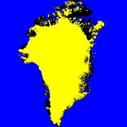
Este conjunto de datos proporciona máscaras completas de clasificación de hielo terrestre y océano a 15 m para la capa de hielo de Groenlandia.
La cobertura de hielo se trazó con una combinación de imágenes pancromáticas ortorrectificadas (banda 8) del sensor Enhanced Thematic Mapper Plus (ETM+) de Landsat 7, distribuidas por el USGS, y las imágenes de amplitud del radar de apertura sintética (SAR) de RADARSAT-1 producidas y distribuidas por I. Joughin en el Applied Physics Laboratory de la University of Washington.
Las imágenes de Landsat se obtuvieron para los meses de julio a septiembre de 1999, 2000 y 2001 (principalmente 2000), y las imágenes de RADARSAT se obtuvieron en el otoño del 2000.
Bandas
Tamaño de píxel 15 metros
Bandas
Nombre
Tamaño de los píxeles
Descripción
ocean_mask
metros
Máscara de océano
ice_mask
metros
Máscara de hielo
Tabla de clases de ocean_mask
Valor
Color
Descripción
0
#000000
Todo el resto del terreno
1
#0000ff
un océano
Tabla de clases de ice_mask
Valor
Color
Descripción
0
#000000
no es hielo glaciar
1
#ffffff
Hielo glaciar
Condiciones de Uso
Condiciones de Uso
Como condición para usar estos datos, debes citar el uso de este conjunto de datos con la cita proporcionada.
Citas
Citas:
Howat, I.M., A. Negrete, B.E. Smith, 2014, The Greenland Ice
Mapping Project (GIMP) land classification and surface elevation
datasets, The Cryosphere, 8, 1509-1518,
doi:10.5194/tc-8-1509-2014article pdf
Este conjunto de datos proporciona máscaras de clasificación completas de hielo terrestre y océano a 15 m para la capa de hielo de Groenlandia. La cobertura de hielo se trazó con una combinación de imágenes pancromáticas ortorrectificadas (banda 8) del sensor Enhanced Thematic Mapper Plus (ETM+) del Landsat 7, distribuidas por el USGS, y el radar de apertura sintética (SAR) de amplitud sintética del RADARSAT-1…
[null,null,[],[[["\u003cp\u003eThis dataset provides 15m resolution land ice and ocean classification masks for the Greenland ice sheet.\u003c/p\u003e\n"],["\u003cp\u003eIt utilizes Landsat 7 ETM+ and RADARSAT-1 SAR imagery primarily acquired between 1999 and 2001.\u003c/p\u003e\n"],["\u003cp\u003eThe dataset includes two bands: \u003ccode\u003eocean_mask\u003c/code\u003e and \u003ccode\u003eice_mask\u003c/code\u003e, identifying ocean and glacier ice respectively.\u003c/p\u003e\n"],["\u003cp\u003eUsers must cite the provided sources when using this dataset, including the Howat et al.(2014) publication.\u003c/p\u003e\n"]]],["The dataset provides 15-meter resolution land ice and ocean classification masks for the Greenland ice sheet, using Landsat 7 ETM+ imagery from July-September (1999-2001) and RADARSAT-1 SAR imagery from fall 2000. It includes `ocean_mask` (0 for other terrain, 1 for ocean) and `ice_mask` (0 for no glacier ice, 1 for glacier ice). Data is available from June 30, 1999, to September 4, 2002, with provider NASA NSIDC DAAC. Access is provided through Google Earth Engine.\n"],null,["# Greenland Ice & Ocean Mask - Greenland Mapping Project (GIMP)\n\nDataset Availability\n: 1999-06-30T00:00:00Z--2002-09-04T00:00:00Z\n\nDataset Provider\n:\n\n\n [NASA NSIDC DAAC at CIRES](https://doi.org/10.5067/B8X58MQBFUPA)\n\nTags\n:\n [arctic](/earth-engine/datasets/tags/arctic) [cryosphere](/earth-engine/datasets/tags/cryosphere) [gimp](/earth-engine/datasets/tags/gimp) [greenland](/earth-engine/datasets/tags/greenland) [ice](/earth-engine/datasets/tags/ice) [nasa](/earth-engine/datasets/tags/nasa) [polar](/earth-engine/datasets/tags/polar) \nmask \n\n#### Description\n\nThis dataset provides complete land ice and ocean\nclassification masks at 15 m for the Greenland ice sheet.\nIce cover was mapped using\na combination of orthorectified panchromatic (band 8)\nimagery from the Landsat 7 Enhanced Thematic Mapper\nPlus (ETM+), distributed by the USGS, and RADARSAT-1\nSynthetic Amplitude Radar (SAR) amplitude images produced\nand distributed by I. Joughin at the Applied Physics\nLaboratory, University of Washington.\n\nThe Landsat imagery was acquired for the months of July\nthrough September in 1999, 2000 and 2001 (mostly 2000)\nand the RADARSAT imagery was acquired in fall of 2000.\n\n### Bands\n\n\n**Pixel Size**\n\n15 meters\n\n**Bands**\n\n| Name | Pixel Size | Description |\n|--------------|------------|-------------|\n| `ocean_mask` | meters | Ocean mask |\n| `ice_mask` | meters | Ice mask |\n\n**ocean_mask Class Table**\n\n| Value | Color | Description |\n|-------|---------|-------------------|\n| 0 | #000000 | all other terrain |\n| 1 | #0000ff | ocean |\n\n**ice_mask Class Table**\n\n| Value | Color | Description |\n|-------|---------|-----------------|\n| 0 | #000000 | not glacier ice |\n| 1 | #ffffff | glacier ice |\n\n### Terms of Use\n\n**Terms of Use**\n\nAs a condition of using these data, you must cite the use of this\ndata set using the given citation.\n\n### Citations\n\nCitations:\n\n- Howat, I.M., A. Negrete, B.E. Smith, 2014, The Greenland Ice\n Mapping Project (GIMP) land classification and surface elevation\n datasets, The Cryosphere, 8, 1509-1518,\n [doi:10.5194/tc-8-1509-2014](https://doi.org/10.5194/tc-8-1509-2014)\n [article pdf](https://www.the-cryosphere.net/8/1509/2014/tc-8-1509-2014.pdf)\n\n### DOIs\n\n- \u003chttps://doi.org/10.5067/B8X58MQBFUPA\u003e\n\n### Explore with Earth Engine\n\n| **Important:** Earth Engine is a platform for petabyte-scale scientific analysis and visualization of geospatial datasets, both for public benefit and for business and government users. Earth Engine is free to use for research, education, and nonprofit use. To get started, please [register for Earth Engine access.](https://console.cloud.google.com/earth-engine)\n\n### Code Editor (JavaScript)\n\n```javascript\nvar dataset = ee.Image('OSU/GIMP/2000_ICE_OCEAN_MASK');\nvar oceanAndIceMaskVis = {\n min: 0.0,\n max: 1.0,\n bands: ['ice_mask', 'ice_mask', 'ocean_mask'],\n};\nMap.setCenter(-41.0, 74.0, 4);\nMap.addLayer(dataset, oceanAndIceMaskVis, 'Ocean and Ice Mask');\n```\n[Open in Code Editor](https://code.earthengine.google.com/?scriptPath=Examples:Datasets/OSU/OSU_GIMP_2000_ICE_OCEAN_MASK) \n[Greenland Ice \\& Ocean Mask - Greenland Mapping Project (GIMP)](/earth-engine/datasets/catalog/OSU_GIMP_2000_ICE_OCEAN_MASK) \nThis dataset provides complete land ice and ocean classification masks at 15 m for the Greenland ice sheet. Ice cover was mapped using a combination of orthorectified panchromatic (band 8) imagery from the Landsat 7 Enhanced Thematic Mapper Plus (ETM+), distributed by the USGS, and RADARSAT-1 Synthetic Amplitude Radar (SAR) ... \nOSU/GIMP/2000_ICE_OCEAN_MASK, arctic,cryosphere,gimp,greenland,ice,nasa,polar \n1999-06-30T00:00:00Z/2002-09-04T00:00:00Z \n58.79601275381146 -89.3211593425295 83.95386175580668 7.555941634834938 \nGoogle Earth Engine \nhttps://developers.google.com/earth-engine/datasets\n\n- [https://doi.org/10.5067/B8X58MQBFUPA](https://doi.org/https://doi.org/10.5067/B8X58MQBFUPA)\n- [https://doi.org/10.5067/B8X58MQBFUPA](https://doi.org/https://developers.google.com/earth-engine/datasets/catalog/OSU_GIMP_2000_ICE_OCEAN_MASK)"]]