- Disponibilidade de conjuntos de dados
- 1999-06-30T00:00:00Z–2002-09-04T00:00:00Z
- Provedor de conjunto de dados
- NASA NSIDC DAAC no CIRES
- Tags
Descrição
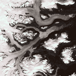
Esse conjunto de dados fornece um mosaico de imagens completo de 15 m de resolução da camada de gelo da Groenlândia, derivado de imagens do Landsat 7 ETM+ e do RADARSAT-1 SAR dos anos de 1999 a 2002. Os métodos incluem uma combinação de mascaramento de nuvem de imagem, nitidez panorâmica, amostragem e redimensionamento de imagens e correlação de imagens. Consulte Howat, 2014 para mais informações sobre métodos de processamento.
Observação
- Os usuários de imagens do GIMP DEM ou do GIMP 2000 Image Mosaic podem achar útil mascarar áreas fora da costa da Groenlândia usando a imagem de máscara oceânica de 15 m correspondente, a máscara de classificação de gelo terrestre e oceano do Projeto de mapeamento de gelo da Groenlândia (GIMP, na sigla em inglês).
- Os dados de SAR são distribuídos com resolução de 20 m. Os dados foram aumentados por interpolação bilinear para 15 m, correspondendo à resolução da banda 8 do Landsat.
Bandas
Bandas
| Nome | Tamanho do pixel | Comprimento de onda | Descrição |
|---|---|---|---|
B1 |
15 metros | 0,45 a 0,52 μm | Azul do Landsat 7 ETM+ |
B2 |
15 metros | 0,52 a 0,60 μm | Landsat 7 ETM+ verde |
B3 |
15 metros | 0,63 a 0,69 μm | Vermelho do Landsat 7 ETM+ |
B4 |
15 metros | 0,77 a 0,90 μm | Infravermelho próximo do Landsat 7 ETM+ |
B5 |
30 metros | 1,55 a 1,75 μm | Infravermelho de ondas curtas 1 do Landsat 7 ETM+ |
B6_low_gain |
30 metros | 10,40 a 12,50 μm | Infravermelho térmico de baixo ganho ETM+ do Landsat 7. Essa banda tem faixa dinâmica expandida e resolução radiométrica (sensibilidade) menor, com menos saturação em valores altos de número digital (DN). Reamostrada de 60 para 30 minutos. |
B6_high_gain |
30 metros | 10,40 a 12,50 μm | Infravermelho térmico de alto ganho ETM+ do Landsat 7. Essa banda tem uma resolução radiométrica (sensibilidade) maior, mas um intervalo dinâmico mais restrito. Reamostrada de 60 para 30 minutos. |
B7 |
30 metros | 2,08 a 2,35 μm | Infravermelho de ondas curtas 2 do Landsat 7 ETM+ |
B8 |
15 metros | 0,52 a 0,90 μm | Pancromático ETM+ do Landsat 7 |
B8_radarsat |
15 metros | Nenhum | Imagens de amplitude de radar de abertura sintética do RADARSAT-1 |
Termos de Uso
Termos de Uso
Como condição para usar esses dados, você precisa citar o uso do conjunto de dados com a citação fornecida.
Citações
Howat, I.M., A. Negrete, B.E. Smith, 2014, The Greenland Ice Mapping Project (GIMP) land classification and surface elevation datasets, The Cryosphere, 8, 1509-1518, doi:10.5194/tc-8-1509-2014 artigo em PDF
DOIs
Explorar com o Earth Engine
Editor de código (JavaScript)
var dataset = ee.Image('OSU/GIMP/2000_IMAGERY_MOSAIC');
var greenlandImage = dataset.select(['B3', 'B2', 'B1']);
var visParams = {
  min: 0.0,
  max: 255.0,
};
Map.setCenter(-29.1605, 70.4, 9);
Map.addLayer(greenlandImage, visParams, 'Greenland Pansharpened Image');