- Disponibilidad del conjunto de datos
- 1999-06-30T00:00:00Z–2002-09-04T00:00:00Z
- Proveedor del conjunto de datos
- DAAC del NSIDC de la NASA en CIRES
- Etiquetas
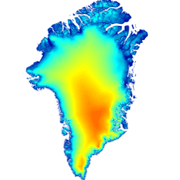
Descripción
Este modelo digital de elevación (MDE) se construyó a partir de una combinación de MDE de ASTER y SPOT-5 para la periferia y el margen de la capa de hielo (es decir, por debajo de la elevación de la línea de equilibrio) al sur de aproximadamente 82.5° N y fotoclinometría de AVHRR en el interior y el extremo norte de la capa de hielo (Scambos y Haran, 2002).
Los MDT de SPOT-5 se produjeron y distribuyeron como parte del proyecto SPIRIT (Spot5 Stereoscopic Survey of Polar Ice: Reference Images & Topographies) (Korona et al., 2009). Las superficies oceánicas se enmascararon con la máscara de clasificación de la tierra de GIMP y se reemplazaron por la altura media de la superficie del mar de CNES CLS11 (Schaeffer et al., 2012).
Nota
- Todos los datos de elevación del terreno se registran horizontal y verticalmente en las elevaciones promedio de ICESat para el período de 2003 a 2009, por lo que el DEM tiene una fecha nominal de 2007, aunque se debe tener cuidado al usar el DEM en áreas de cambio rápido, como los principales glaciares de salida al sur de los 70°0N.
- El MDT tiene una resolución de 30 m, aunque la resolución "real" del MDT variará de 40 m en las áreas de cobertura de SPOT-5 (consulta Korona et al., 2009) a 500 m en las áreas de fotoclinometría.
- El error de validación de la raíz cuadrada media en toda la capa de hielo en relación con ICESat es de +/-10 m, y varía de cerca de +/-1 m en la mayoría de las superficies de hielo a +/-30 m en áreas de gran relieve.
Bandas
Bandas
Tamaño de píxel: 30 metros (todas las bandas)
| Nombre | Unidades | Tamaño de los píxeles | Descripción |
|---|---|---|---|
elevation |
m | 30 metros | Elevación |
Condiciones de Uso
Condiciones de Uso
Como condición para usar estos datos, debes citar el uso de este conjunto de datos con la cita proporcionada.
Citas
Howat, I.M., A. Negrete, B.E. Smith, 2014, The Greenland Ice Mapping Project (GIMP) land classification and surface elevation datasets, The Cryosphere, 8, 1509-1518, doi:10.5194/tc-8-1509-2014 pdf del artículo
DOI
Explora con Earth Engine
Editor de código (JavaScript)
var dataset = ee.Image('OSU/GIMP/DEM');
var elevation = dataset.select('elevation');
var elevationVis = {
  min: 0.0,
  max: 2000.0,
};
Map.setCenter(-41.0, 76.0, 4);
Map.addLayer(elevation, elevationVis, 'Elevation');