- در دسترس بودن مجموعه دادهها
- 1999-06-30T00:00:00Z–2002-09-04T00:00:00Z
- تولیدکننده مجموعه داده
- ناسا NSIDC DAAC در CIRES
- برچسبها
توضیحات
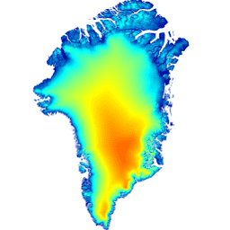
این مدل ارتفاعی رقومی (DEM) از ترکیبی از DEM های ASTER و SPOT-5 برای حاشیه و پیرامون پهنه یخی (یعنی زیر ارتفاع خط تعادل) در جنوب تقریباً 82.5 درجه شمالی و فوتوکلینومتری AVHRR در داخل پهنه یخی و شمال دور ساخته شده است (Scambos and Haran, 2002).
DEM های SPOT-5 به عنوان بخشی از پروژه بررسی استریوسکوپی Spot5 از یخ قطبی: تصاویر و توپوگرافیهای مرجع (SPIRIT) تولید و توزیع شدند (Korona و همکاران، ۲۰۰۹). سطوح اقیانوس با استفاده از ماسک طبقهبندی زمین GIMP پوشانده شده و با ارتفاع متوسط سطح دریا CNES CLS11 جایگزین شدند (Schaeffer و همکاران، ۲۰۱۲).
توجه داشته باشید
- تمام دادههای ارتفاع زمین به صورت افقی و عمودی بر اساس میانگین ارتفاع ICESat برای دوره زمانی ۲۰۰۳-۲۰۰۹ ثبت شدهاند و بنابراین DEM دارای تاریخ اسمی ۲۰۰۷ است، اگرچه هنگام استفاده از DEM در مناطقی با تغییرات سریع، مانند یخچالهای طبیعی خروجی اصلی در جنوب ۷۰ درجه شمالی، باید احتیاط کرد.
- DEM دارای وضوح 30 متر است، اگرچه وضوح "واقعی" DEM از 40 متر در مناطق تحت پوشش SPOT-5 (به Korona و همکاران، 2009 مراجعه کنید) تا 500 متر در مناطق تحت پوشش فوتوکلینومتری متغیر خواهد بود.
- خطای اعتبارسنجی جذر میانگین مربعات در سطح کل پهنه یخی نسبت به ICESat، +/-10 متر است که از نزدیک به +/-1 متر در بیشتر سطوح یخی تا +/-30 متر در مناطق با پستی و بلندی زیاد متغیر است.
باندها
باندها
اندازه پیکسل: 30 متر (همه باندها)
| نام | واحدها | اندازه پیکسل | توضیحات |
|---|---|---|---|
elevation | متر | ۳۰ متر | ارتفاع |
شرایط استفاده
شرایط استفاده
به عنوان شرط استفاده از این دادهها، باید با استفاده از منبع داده شده، به استفاده از این مجموعه دادهها استناد کنید.
نقل قولها
هاوات، آی. ام، ای. نگرت، بی. ای. اسمیت، ۲۰۱۴، طبقهبندی زمین و مجموعه دادههای ارتفاع سطح پروژه نقشهبرداری یخ گرینلند (GIMP)، کرایوسفر، ۸، ۱۵۰۹-۱۵۱۸، doi:10.5194/tc-8-1509-2014 مقاله پیدیاف
DOI ها
با موتور زمین کاوش کنید
ویرایشگر کد (جاوااسکریپت)
var dataset = ee.Image('OSU/GIMP/DEM');
var elevation = dataset.select('elevation');
var elevationVis = {
  min: 0.0,
  max: 2000.0,
};
Map.setCenter(-41.0, 76.0, 4);
Map.addLayer(elevation, elevationVis, 'Elevation');