OpenET 프레임워크 내 PT-JPL 모델의 핵심 공식은 Fisher et al. (2008)에 자세히 설명된 원래 공식에서 변경되지 않았습니다.
하지만 PT-JPL의 모델 입력 및 시간 통합을 개선하고 업데이트하여 최신 격자형 날씨 데이터 세트를 활용하고, 다른 모델과의 일관성을 제공하고, 개방된 물 증발 추정치를 개선하고, 반건조 및 건조 환경에서 농작물 및 습지 지역의 이류를 고려했습니다. 이러한 변경사항에는 순 복사, 광합성 활성 복사, 식물 캐노피 및 수분 변수를 계산하기 위한 Landsat 표면 반사율 및 열 복사 사용과 일사량 및 ASCE 참조 ET를 추정하기 위한 NLDAS, Spatial CIMIS, gridMET 날씨 데이터 사용이 포함됩니다. 다른 OpenET 모델의 구현과 마찬가지로 일일 및 월간 시간 통합 ET의 추정은 ASCE 참조 ET의 비율을 기반으로 합니다. 개방된 물의 증발은 토양 열 플럭스와 달리 물 열 플럭스를 고려하여 수역에 특화된 Abdelrady 등(2016)의 표면 에너지 균형 접근법에 따라 추정됩니다.
Fisher, J.B., Tu, K.P. 및 Baldocchi, D.D., 2008. 16개 FLUXNET 사이트에서 검증된 월별 AVHRR 및 ISLSCP-II 데이터를 기반으로 한 토지-대기 물 플럭스의 전역 추정치 Remote Sensing of Environment, 112(3),
pp.901-919.
doi:10.1016/j.rse.2007.06.025
Abdelrady, A., Timmermans, J., Vekerdy, Z., Salama, M., 2016년.
담수와 염수의 표면 에너지 균형: AquaSEBS. Remote
sensing, 8(7), p.583.
doi:10.3390/rs8070583
프리슬리-테일러 제트 추진 연구소 (PT-JPL): OpenET 프레임워크 내 PT-JPL 모델의 핵심 공식은 Fisher et al. (2008)에 자세히 설명된 원래 공식에서 변경되지 않았습니다. 하지만 최신 격자형 날씨 데이터를 활용하기 위해 PT-JPL의 모델 입력 및 시간 통합이 개선되고 업데이트되었습니다.
[null,null,[],[[["\u003cp\u003eThe OpenET PT-JPL dataset provides monthly evapotranspiration estimates for the contiguous United States (CONUS) from 2008 to 2023.\u003c/p\u003e\n"],["\u003cp\u003eIt is based on the Priestley-Taylor Jet Propulsion Laboratory (PT-JPL) model, utilizing Landsat and gridMET data for improved accuracy.\u003c/p\u003e\n"],["\u003cp\u003eThe dataset is available at a 30-meter resolution and includes bands for evapotranspiration and the number of cloud-free observations used in the estimation.\u003c/p\u003e\n"],["\u003cp\u003eOpenET data is made available under the Creative Commons Attribution 4.0 International (CC BY 4.0) license.\u003c/p\u003e\n"],["\u003cp\u003eThis dataset can be accessed and analyzed using Google Earth Engine.\u003c/p\u003e\n"]]],["The dataset, provided by OpenET, Inc., offers monthly evapotranspiration (ET) data from 1999-10-01 to 2023-12-01, calculated using the Priestley-Taylor Jet Propulsion Laboratory (PT-JPL) model. This model uses Landsat data for variables and weather data to estimate ET, including adjustments for open water and advection. It outputs `et` values (mm) and a cloud-free `count`, with a 30-meter pixel size. The dataset is accessible through Google Earth Engine, which also provides an example code for annual evapotranspiration calculations.\n"],null,["# OpenET PT-JPL Monthly Evapotranspiration v2.0\n\nDataset Availability\n: 1999-10-01T00:00:00Z--2024-12-01T00:00:00Z\n\nDataset Provider\n:\n\n\n [OpenET, Inc.](https://openetdata.org/)\n\nCadence\n: 1 Month\n\nTags\n:\n[evapotranspiration](/earth-engine/datasets/tags/evapotranspiration) [gridmet-derived](/earth-engine/datasets/tags/gridmet-derived) [landsat-derived](/earth-engine/datasets/tags/landsat-derived) [monthly](/earth-engine/datasets/tags/monthly) [openet](/earth-engine/datasets/tags/openet) [water](/earth-engine/datasets/tags/water) [water-vapor](/earth-engine/datasets/tags/water-vapor) \n\n#### Description\n\nPriestley-Taylor Jet Propulsion Laboratory (PT-JPL)\n\nThe core formulation of the PT-JPL model within the OpenET framework has\nnot changed from the original formulation detailed in Fisher et al. (2008).\nHowever, enhancements and updates to model inputs and time integration for\nPT-JPL were made to take advantage of contemporary gridded weather datasets,\nprovide consistency with other models, improve open water evaporation\nestimates, and account for advection over crop and wetland areas in\nsemiarid and arid environments. These changes include the use of\nLandsat surface reflectance and thermal radiation for calculating net\nradiation, photosynthetically active radiation, plant canopy and moisture\nvariables, and use of NLDAS, Spatial CIMIS, and gridMET weather data for\nestimating insolation and ASCE reference ET. Similar to the implementation\nof other OpenET models, estimation of daily and monthly time integrated\nET is based on the fraction of ASCE reference ET. Open water evaporation\nis estimated following a surface energy balance approach of Abdelrady\net al. (2016) that is specific for water bodies by accounting for water\nheat flux as opposed to soil heat flux.\n\n[Additional information](https://openetdata.org/methodologies/)\n\n### Bands\n\n\n**Pixel Size**\n\n30 meters\n\n**Bands**\n\n| Name | Units | Pixel Size | Description |\n|---------|-------|------------|-----------------------------|\n| `et` | mm | meters | PT-JPL ET value |\n| `count` | count | meters | Number of cloud free values |\n\n### Image Properties\n\n**Image Properties**\n\n| Name | Type | Description |\n|-----------------------|--------|----------------------------------------------------------------------------------------------|\n| build_date | STRING | Date assets were built |\n| cloud_cover_max | DOUBLE | Maximum CLOUD_COVER_LAND percent value for Landsat images included in interpolation |\n| collections | STRING | List of Landsat collections for Landsat images included in the interpolation |\n| core_version | STRING | OpenET core library version |\n| end_date | STRING | End date of month |\n| et_reference_band | STRING | Band in et_reference_source that contains the daily reference ET data |\n| et_reference_resample | STRING | Spatial interpolation mode to resample daily reference ET data |\n| et_reference_source | STRING | Collection ID for the daily reference ET data |\n| interp_days | DOUBLE | Maximum number of days before and after each image date to include in interpolation |\n| interp_method | STRING | Method used to interpolate between Landsat model estimates |\n| interp_source_count | DOUBLE | Number of available images in the interpolation source image collection for the target month |\n| mgrs_tile | STRING | MGRS grid zone ID |\n| model_name | STRING | OpenET model name |\n| model_version | STRING | OpenET model version |\n| scale_factor_count | DOUBLE | Scaling factor that should be applied to the count band |\n| scale_factor_et | DOUBLE | Scaling factor that should be applied to the et band |\n| start_date | STRING | Start date of month |\n\n### Terms of Use\n\n**Terms of Use**\n\n[CC-BY-4.0](https://spdx.org/licenses/CC-BY-4.0.html)\n\n### Citations\n\nCitations:\n\n- Fisher, J.B., Tu, K.P. and Baldocchi, D.D., 2008. Global estimates of the\n land--atmosphere water flux based on monthly AVHRR and ISLSCP-II data,\n validated at 16 FLUXNET sites. Remote Sensing of Environment, 112(3),\n pp.901-919.\n [doi:10.1016/j.rse.2007.06.025](https://doi.org/10.1016/j.rse.2007.06.025)\n- Abdelrady, A., Timmermans, J., Vekerdy, Z. and Salama, M., 2016.\n Surface energy balance of fresh and saline waters: AquaSEBS. Remote\n sensing, 8(7), p.583.\n [doi:10.3390/rs8070583](https://doi.org/10.3390/rs8070583)\n\n### DOIs\n\n- \u003chttps://doi.org/10.1016/j.rse.2007.06.025\u003e\n\n### Explore with Earth Engine\n\n| **Important:** Earth Engine is a platform for petabyte-scale scientific analysis and visualization of geospatial datasets, both for public benefit and for business and government users. Earth Engine is free to use for research, education, and nonprofit use. To get started, please [register for Earth Engine access.](https://console.cloud.google.com/earth-engine)\n\n### Code Editor (JavaScript)\n\n```javascript\n
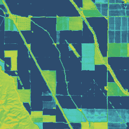
var dataset = ee.ImageCollection('OpenET/PTJPL/CONUS/GRIDMET/MONTHLY/v2_0')\n .filterDate('2020-01-01', '2021-01-01');\n\n// Compute the annual evapotranspiration (ET) as the sum of the monthly ET\n// images for the year.\nvar et = dataset.select('et').sum();\n\nvar visualization = {\n min: 0,\n max: 1400,\n palette: [\n '9e6212', 'ac7d1d', 'ba9829', 'c8b434', 'd6cf40', 'bed44b', '9fcb51',\n '80c256', '61b95c', '42b062', '45b677', '49bc8d', '4dc2a2', '51c8b8',\n '55cece', '4db4ba', '459aa7', '3d8094', '356681', '2d4c6e',\n ]\n};\n\nMap.setCenter(-100, 38, 5);\n\nMap.addLayer(et, visualization, 'OpenET PT-JPL Annual ET');\n```\n[Open in Code Editor](https://code.earthengine.google.com/?scriptPath=Examples:Datasets/OpenET/OpenET_PTJPL_CONUS_GRIDMET_MONTHLY_v2_0) \n[OpenET PT-JPL Monthly Evapotranspiration v2.0](/earth-engine/datasets/catalog/OpenET_PTJPL_CONUS_GRIDMET_MONTHLY_v2_0) \nPriestley-Taylor Jet Propulsion Laboratory (PT-JPL) The core formulation of the PT-JPL model within the OpenET framework has not changed from the original formulation detailed in Fisher et al. (2008). However, enhancements and updates to model inputs and time integration for PT-JPL were made to take advantage of contemporary gridded weather ... \nOpenET/PTJPL/CONUS/GRIDMET/MONTHLY/v2_0, evapotranspiration,gridmet-derived,landsat-derived,monthly,openet,water,water-vapor \n1999-10-01T00:00:00Z/2024-12-01T00:00:00Z \n25 -126 50 -66 \nGoogle Earth Engine \nhttps://developers.google.com/earth-engine/datasets\n\n- [https://doi.org/10.1016/j.rse.2007.06.025](https://doi.org/https://openetdata.org/)\n- [https://doi.org/10.1016/j.rse.2007.06.025](https://doi.org/https://developers.google.com/earth-engine/datasets/catalog/OpenET_PTJPL_CONUS_GRIDMET_MONTHLY_v2_0)"]]