Operational Simplified Surface Energy Balance (SSEBop)
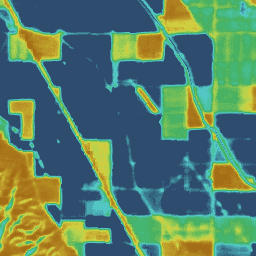
Senay 등 (2013, 2017)의 Operational Simplified Surface Energy Balance(SSEBop) 모델은 위성 습도계의 원리(Senay 2018)에 따라 실제 ET를 추정하기 위한 열 기반의 단순화된 표면 에너지 모델입니다. OpenET SSEBop 구현에서는 Landsat(컬렉션 2 레벨 2 과학 제품)의 지표 온도 (Ts)를 사용하며, 관측된 지표 온도, 정규화된 차이 식생 지수 (NDVI), Daymet의 기후학적 평균 (1980~2017년) 일일 최대 기온(Ta, 1km), ERA-5의 순 복사 데이터의 조합에서 파생된 주요 모델 매개변수 (냉/습구 기준, Tc, 표면 습도계 상수, 1/dT)를 사용합니다. 이 모델 구현에서는 중간 및 집계된 ET 결과를 모두 생성할 때 주요 SSEBop ET 함수와 알고리즘을 함께 연결하기 위해 Google Earth Engine 처리 프레임워크를 사용합니다. 미국 전역에 걸친 SSEBop 모델에 대한 자세한 연구 및 평가(Senay et al., 2022)은 광범위한 규모의 물 수지 애플리케이션에 대한 클라우드 구현과 평가 모두에 정보를 제공합니다. 주요 모델 (v0.2.6) 개선사항과 이전 버전 대비 성능에는 Landsat 9 (2021년 9월 출시)와의 추가 호환성, 전역 모델 확장성, FANO (강제 및 정규화 작업)를 사용하여 모든 지형과 모든 계절에서 식물 피복 밀도와 관계없이 ET를 더 잘 추정하여 모델 정확도를 개선하는 SSEBop의 매개변수화 개선이 포함됩니다. 이를 통해 Tc를 비보정 지역으로 외삽하지 않아도 됩니다.
Senay, G.B., Parrish, G.E., Schauer, M., Friedrichs, M., Khand, K., Boiko,
O., Kagone, S., Dittmeier, R., Arab, S. 및 Ji, L., 2023. 강제 및 정규화 작업을 사용하여 운영 단순화된 표면 에너지 균형 증발산 모델 개선 Remote Sensing, 15(1), p.260.
doi:10.3390/rs15010260
Senay, G.B., Bohms, S., Singh, R.K., Gowda, P.H., Velpuri, N.M., Alemu,
H. and Verdin, J.P., 2013년 원격 감지 및 날씨 데이터 세트를 사용한 운영 증발산량 매핑: SSEB 접근 방식의 새로운 매개변수화 JAWRA Journal of the American Water Resources Association,
49(3), pp.577-591.
doi:10.1111/jawr.12057
Senay, G.B., Schauer, M., Friedrichs, M., Velpuri, N.M. 및 Singh, R.K.,
2017. 미국 남서부에서 이전 Landsat 데이터(1984~2014년)를 사용한 위성 기반 물 사용 역학 Remote Sensing of
Environment, 202, pp.98-112.
doi:10.1016/j.rse.2017.05.005c
Senay, G.B., 2018년. 증발산량을 정량화하고 매핑하기 위한 운영 단순화된 표면 에너지 균형 (SSEBop) 모델의 위성 습도계 공식입니다. Applied Engineering in
Agriculture, 34(3), pp.555-566.
doi:10.13031/aea.12614
Senay, G.B., Friedrichs, M., Morton, C., Parrish, G.E., Schauer, M.,
Khand, K., Kagone, S., Boiko, O. 및 Huntington, J., 2022년. 미국 본토의 실제 증발산량 매핑: Google Earth Engine 구현 및 SSEBop 모델 평가 Remote Sensing of Environment, 275, p.113011.
doi:10.1016/j.rse.2022.113011
운영 단순화된 지표면 에너지 균형 (SSEBop) Senay 외 (2013, 2017)의 운영 단순화된 지표면 에너지 균형(SSEBop) 모델은 위성 습도계의 원리 (Senay 2018)에 따라 실제 ET를 추정하기 위한 열 기반 단순화된 지표면 에너지 모델입니다. OpenET SSEBop 구현은 다음의 지표에서 지표면 온도 (Ts)를 사용합니다.
[null,null,[],[[["\u003cp\u003eThe OpenET SSEBop dataset provides monthly evapotranspiration (ET) estimates for the contiguous United States (CONUS) from 2008 to 2023.\u003c/p\u003e\n"],["\u003cp\u003eIt leverages the Operational Simplified Surface Energy Balance (SSEBop) model, utilizing Landsat and GRIDMET data for calculations.\u003c/p\u003e\n"],["\u003cp\u003eThe dataset offers 30-meter resolution imagery with bands representing ET values and the number of cloud-free observations used in the estimation.\u003c/p\u003e\n"],["\u003cp\u003eData is freely available under the CC-BY-4.0 license and is accessible through the Google Earth Engine platform.\u003c/p\u003e\n"],["\u003cp\u003eOpenET SSEBop is extensively documented with publications detailing its methodology, validation, and applications in water balance studies.\u003c/p\u003e\n"]]],["The dataset provides monthly evapotranspiration (ET) estimates from the Operational Simplified Surface Energy Balance (SSEBop) model, covering 1999-10-01 to 2023-12-01. The model, implemented by OpenET, uses Landsat surface temperature data and other sources to derive actual ET. Key improvements include Landsat 9 compatibility, global model extension, and enhanced parameterization for better ET estimation across landscapes. Users can access the data via Google Earth Engine, with a 30-meter pixel size. Data, provided by [OpenET, Inc.](https://openetdata.org/), is under CC-BY-4.0.\n"],null,["# OpenET SSEBop Monthly Evapotranspiration v2.0\n\nDataset Availability\n: 1999-10-01T00:00:00Z--2024-12-01T00:00:00Z\n\nDataset Provider\n:\n\n\n [OpenET, Inc.](https://openetdata.org/)\n\nCadence\n: 1 Month\n\nTags\n:\n[evapotranspiration](/earth-engine/datasets/tags/evapotranspiration) [gridmet-derived](/earth-engine/datasets/tags/gridmet-derived) [landsat-derived](/earth-engine/datasets/tags/landsat-derived) [monthly](/earth-engine/datasets/tags/monthly) [openet](/earth-engine/datasets/tags/openet) [water](/earth-engine/datasets/tags/water) [water-vapor](/earth-engine/datasets/tags/water-vapor) \n\n#### Description\n\nOperational Simplified Surface Energy Balance (SSEBop)\n\nThe Operational Simplified Surface Energy Balance (SSEBop) model by Senay\net al. (2013, 2017) is a thermal-based simplified surface energy model for\nestimating actual ET based on the principles of satellite psychrometry\n(Senay 2018). The OpenET SSEBop implementation uses land surface temperature\n(Ts) from Landsat (Collection 2 Level-2 Science Products) with key model\nparameters (cold/wet-bulb reference, Tc, and surface psychrometric\nconstant, 1/dT) derived from a combination of observed surface temperature,\nnormalized difference vegetation index (NDVI), climatological average\n(1980-2017) daily maximum air temperature (Ta, 1-km) from Daymet, and\nnet radiation data from ERA-5. This model implementation uses the Google\nEarth Engine processing framework for connecting key SSEBop ET functions\nand algorithms together when generating both intermediate and aggregated ET\nresults. A detailed study and evaluation of the SSEBop model across CONUS\n(Senay et al., 2022) informs both cloud implementation and assessment for\nwater balance applications at broad scales. Notable model (v0.2.6)\nenhancements and performance against previous versions include additional\ncompatibility with Landsat 9 (launched Sep 2021), global model\nextensibility, and improved parameterization of SSEBop using\nFANO (Forcing and Normalizing Operation) to better estimate ET\nin all landscapes and all seasons regardless of vegetation cover density,\nthereby improving model accuracy by avoiding extrapolation of Tc to\nnon-calibration regions.\n\n[Additional information](https://openetdata.org/methodologies/)\n\n### Bands\n\n\n**Pixel Size**\n\n30 meters\n\n**Bands**\n\n| Name | Units | Pixel Size | Description |\n|---------|-------|------------|-----------------------------|\n| `et` | mm | meters | SSEBop ET value |\n| `count` | count | meters | Number of cloud free values |\n\n### Image Properties\n\n**Image Properties**\n\n| Name | Type | Description |\n|-----------------------|--------|----------------------------------------------------------------------------------------------|\n| build_date | STRING | Date assets were built |\n| cloud_cover_max | DOUBLE | Maximum CLOUD_COVER_LAND percent value for Landsat images included in interpolation |\n| collections | STRING | List of Landsat collections for Landsat images included in the interpolation |\n| core_version | STRING | OpenET core library version |\n| end_date | STRING | End date of month |\n| et_reference_band | STRING | Band in et_reference_source that contains the daily reference ET data |\n| et_reference_resample | STRING | Spatial interpolation mode to resample daily reference ET data |\n| et_reference_source | STRING | Collection ID for the daily reference ET data |\n| interp_days | DOUBLE | Maximum number of days before and after each image date to include in interpolation |\n| interp_method | STRING | Method used to interpolate between Landsat model estimates |\n| interp_source_count | DOUBLE | Number of available images in the interpolation source image collection for the target month |\n| mgrs_tile | STRING | MGRS grid zone ID |\n| model_name | STRING | OpenET model name |\n| model_version | STRING | OpenET model version |\n| scale_factor_count | DOUBLE | Scaling factor that should be applied to the count band |\n| scale_factor_et | DOUBLE | Scaling factor that should be applied to the et band |\n| start_date | STRING | Start date of month |\n\n### Terms of Use\n\n**Terms of Use**\n\n[CC-BY-4.0](https://spdx.org/licenses/CC-BY-4.0.html)\n\n### Citations\n\nCitations:\n\n- Senay, G.B., Parrish, G.E., Schauer, M., Friedrichs, M., Khand, K., Boiko,\n O., Kagone, S., Dittmeier, R., Arab, S. and Ji, L., 2023. Improving the\n Operational Simplified Surface Energy Balance Evapotranspiration Model Using\n the Forcing and Normalizing Operation. Remote Sensing, 15(1), p.260.\n [doi:10.3390/rs15010260](https://doi.org/10.3390/rs15010260)\n- Senay, G.B., Bohms, S., Singh, R.K., Gowda, P.H., Velpuri, N.M., Alemu,\n H. and Verdin, J.P., 2013. Operational evapotranspiration mapping using\n remote sensing and weather datasets: A new parameterization for the SSEB\n approach. JAWRA Journal of the American Water Resources Association,\n 49(3), pp.577-591.\n [doi:10.1111/jawr.12057](https://doi.org/10.1111/jawr.12057)\n- Senay, G.B., Schauer, M., Friedrichs, M., Velpuri, N.M. and Singh, R.K.,\n 2017. Satellite-based water use dynamics using historical Landsat data\n (1984--2014) in the southwestern United States. Remote Sensing of\n Environment, 202, pp.98-112.\n [doi:10.1016/j.rse.2017.05.005c](https://doi.org/10.1016/j.rse.2017.05.005)\n- Senay, G.B., 2018. Satellite psychrometric formulation of the\n Operational Simplified Surface Energy Balance (SSEBop) model for\n quantifying and mapping evapotranspiration. Applied Engineering in\n Agriculture, 34(3), pp.555-566.\n [doi:10.13031/aea.12614](https://doi.org/10.13031/aea.12614)\n- Senay, G.B., Friedrichs, M., Morton, C., Parrish, G.E., Schauer, M.,\n Khand, K., Kagone, S., Boiko, O. and Huntington, J., 2022. Mapping\n actual evapotranspiration using Landsat for the conterminous United\n States: Google Earth Engine implementation and assessment of the SSEBop\n model. Remote Sensing of Environment, 275, p.113011.\n [doi:10.1016/j.rse.2022.113011](https://doi.org/10.1016/j.rse.2022.113011)\n\n### DOIs\n\n- \u003chttps://doi.org/10.3390/rs15010260\u003e\n\n### Explore with Earth Engine\n\n| **Important:** Earth Engine is a platform for petabyte-scale scientific analysis and visualization of geospatial datasets, both for public benefit and for business and government users. Earth Engine is free to use for research, education, and nonprofit use. To get started, please [register for Earth Engine access.](https://console.cloud.google.com/earth-engine)\n\n### Code Editor (JavaScript)\n\n```javascript\nvar dataset = ee.ImageCollection('OpenET/SSEBOP/CONUS/GRIDMET/MONTHLY/v2_0')\n .filterDate('2020-01-01', '2021-01-01');\n\n// Compute the annual evapotranspiration (ET) as the sum of the monthly ET\n// images for the year.\nvar et = dataset.select('et').sum();\n\nvar visualization = {\n min: 0,\n max: 1400,\n palette: [\n '9e6212', 'ac7d1d', 'ba9829', 'c8b434', 'd6cf40', 'bed44b', '9fcb51',\n '80c256', '61b95c', '42b062', '45b677', '49bc8d', '4dc2a2', '51c8b8',\n '55cece', '4db4ba', '459aa7', '3d8094', '356681', '2d4c6e',\n ]\n};\n\nMap.setCenter(-100, 38, 5);\n\nMap.addLayer(et, visualization, 'OpenET SSEBop Annual ET');\n```\n[Open in Code Editor](https://code.earthengine.google.com/?scriptPath=Examples:Datasets/OpenET/OpenET_SSEBOP_CONUS_GRIDMET_MONTHLY_v2_0) \n[OpenET SSEBop Monthly Evapotranspiration v2.0](/earth-engine/datasets/catalog/OpenET_SSEBOP_CONUS_GRIDMET_MONTHLY_v2_0) \nOperational Simplified Surface Energy Balance (SSEBop) The Operational Simplified Surface Energy Balance (SSEBop) model by Senay et al. (2013, 2017) is a thermal-based simplified surface energy model for estimating actual ET based on the principles of satellite psychrometry (Senay 2018). The OpenET SSEBop implementation uses land surface temperature (Ts) from ... \nOpenET/SSEBOP/CONUS/GRIDMET/MONTHLY/v2_0, evapotranspiration,gridmet-derived,landsat-derived,monthly,openet,water,water-vapor \n1999-10-01T00:00:00Z/2024-12-01T00:00:00Z \n25 -126 50 -66 \nGoogle Earth Engine \nhttps://developers.google.com/earth-engine/datasets\n\n- [https://doi.org/10.3390/rs15010260](https://doi.org/https://openetdata.org/)\n- [https://doi.org/10.3390/rs15010260](https://doi.org/https://developers.google.com/earth-engine/datasets/catalog/OpenET_SSEBOP_CONUS_GRIDMET_MONTHLY_v2_0)"]]