- ডেটাসেটের প্রাপ্যতা
- 2007-01-01T00:00:00Z–2019-01-01T00:00:00Z
- ডেটাসেট প্রযোজক
- এনভাইরোমেট্রিক্স লিমিটেড
- ট্যাগ
বর্ণনা
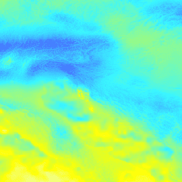
SM2RAIN-ASCAT 2007-2018 , IMERG, CHELSA Climate, এবং WorldClim-এর উপর ভিত্তি করে ১ কিমি রেজোলিউশনে মাসিক বৃষ্টিপাত (মিমি এককে)।
gdalwarp (কিউবিক স্প্লাইন) এবং WorldClim , CHELSA Climate , ও IMERG-এর মাসিক প্রোডাক্টের গড় ব্যবহার করে ১ কিমি রেজোলিউশনে ডাউনস্কেল করা হয়েছে (উদাহরণস্বরূপ, "3B-MO-L.GIS.IMERG.20180601.V05B.tif" দেখুন)। SM2RAIN-ASCAT ডেটাকে ৩ গুণ বেশি গুরুত্ব দেওয়া হয়েছে, কারণ এটিকে অধিক নির্ভুল বলে ধরে নেওয়া হয়েছে। প্রসেসিং-এর ধাপগুলো এখানে পাওয়া যাবে। অ্যান্টার্কটিকা অন্তর্ভুক্ত নয়।
আর্থ ইঞ্জিনের বাইরে মানচিত্র দেখতে ও উপলব্ধি করতে এই পৃষ্ঠাটি ব্যবহার করুন।
যদি আপনি LandGIS মানচিত্রে কোনো ত্রুটি, অসঙ্গতি বা অসামঞ্জস্য খুঁজে পান অথবা আপনার কোনো প্রশ্ন থাকে, তাহলে অনুগ্রহ করে নিম্নলিখিত মাধ্যমগুলো ব্যবহার করুন:
ব্যান্ড
ব্যান্ড
পিক্সেল সাইজ: ১০০০ মিটার (সকল ব্যান্ড)
| নাম | ইউনিট | মিনিট | ম্যাক্স | পিক্সেল আকার | বর্ণনা |
|---|---|---|---|---|---|
jan | মিমি | ০* | ৩৮০* | ১০০০ মিটার | জানুয়ারী মাসের মাসিক বৃষ্টিপাত |
feb | মিমি | ০* | ৩৮০* | ১০০০ মিটার | ফেব্রুয়ারী মাসের মাসিক বৃষ্টিপাত |
mar | মিমি | ০* | ৩৮০* | ১০০০ মিটার | মার্চ মাসের মাসিক বৃষ্টিপাত |
apr | মিমি | ০* | ৩৮০* | ১০০০ মিটার | এপ্রিল মাসের মাসিক বৃষ্টিপাত |
may | মিমি | ০* | ৩৮০* | ১০০০ মিটার | মে মাসের মাসিক বৃষ্টিপাত |
jun | মিমি | ০* | ৩৮০* | ১০০০ মিটার | জুন মাসের মাসিক বৃষ্টিপাত |
jul | মিমি | ০* | ৩৮০* | ১০০০ মিটার | জুলাই মাসের মাসিক বৃষ্টিপাত |
aug | মিমি | ০* | ৩৮০* | ১০০০ মিটার | আগস্ট মাসের মাসিক বৃষ্টিপাত |
sep | মিমি | ০* | ৩৮০* | ১০০০ মিটার | সেপ্টেম্বর মাসের মাসিক বৃষ্টিপাত |
oct | মিমি | ০* | ৩৮০* | ১০০০ মিটার | অক্টোবর মাসের মাসিক বৃষ্টিপাত |
nov | মিমি | ০* | ৩৮০* | ১০০০ মিটার | নভেম্বর মাসের মাসিক বৃষ্টিপাত |
dec | মিমি | ০* | ৩৮০* | ১০০০ মিটার | ডিসেম্বর মাসের মাসিক বৃষ্টিপাত |
ব্যবহারের শর্তাবলী
ব্যবহারের শর্তাবলী
এটি লাইসেন্সের একটি পাঠযোগ্য সারসংক্ষেপ (এবং এর বিকল্প নয়)।
আপনি স্বাধীনভাবে - শেয়ার করতে পারেন - যেকোনো মাধ্যম বা ফরম্যাটে উপাদানটি কপি ও পুনঃবিতরণ করতে পারেন; অভিযোজন করতে পারেন - যেকোনো উদ্দেশ্যে, এমনকি বাণিজ্যিকভাবেও, উপাদানটি রিমিক্স, রূপান্তর এবং এর উপর ভিত্তি করে নতুন কিছু তৈরি করতে পারেন।
এই লাইসেন্সটি মুক্ত সাংস্কৃতিক কাজের জন্য গ্রহণযোগ্য। আপনি লাইসেন্সের শর্তাবলী মেনে চললে, লাইসেন্সদাতা এই স্বাধীনতাগুলো প্রত্যাহার করতে পারবেন না।
নিম্নলিখিত শর্তাবলী সাপেক্ষে - স্বীকৃতি - আপনাকে অবশ্যই যথাযথ কৃতিত্ব দিতে হবে, লাইসেন্সের একটি লিঙ্ক প্রদান করতে হবে এবং কোনো পরিবর্তন করা হলে তা উল্লেখ করতে হবে। আপনি যেকোনো যুক্তিসঙ্গত উপায়ে তা করতে পারেন, কিন্তু এমন কোনোভাবে নয় যা থেকে মনে হয় যে লাইসেন্সদাতা আপনাকে বা আপনার ব্যবহারকে সমর্থন করছেন।
শেয়ারঅ্যালাইক - আপনি যদি এই উপাদানটি রিমিক্স, রূপান্তর বা এর উপর ভিত্তি করে কিছু তৈরি করেন, তবে আপনাকে অবশ্যই আপনার অবদানগুলি মূলটির লাইসেন্সের অধীনে বিতরণ করতে হবে।
কোনো অতিরিক্ত বিধিনিষেধ নয় - আপনি এমন কোনো আইনি শর্ত বা প্রযুক্তিগত ব্যবস্থা প্রয়োগ করতে পারবেন না, যা লাইসেন্স দ্বারা অনুমোদিত কোনো কাজ করা থেকে অন্যদেরকে আইনত সীমাবদ্ধ করে।
উদ্ধৃতি
SM2RAIN-ASCAT 2007-2018 এবং IMERG 2014-2018 এর উপর ভিত্তি করে 1 কিমি রেজোলিউশনে মাসিক বৃষ্টিপাত (মিমি-তে) 10.5281/zenodo.1435912
DOI
আর্থ ইঞ্জিন দিয়ে অন্বেষণ করুন
কোড এডিটর (জাভাস্ক্রিপ্ট)
var dataset = ee.Image('OpenLandMap/CLM/CLM_PRECIPITATION_SM2RAIN_M/v01');

var visualization = {
  bands: ['jan'],
  min: 0.0,
  max: 380.0,
  palette: ['ecffbd', 'ffff00', '3af6ff', '467aff', '313eff', '0008ff']
};

Map.centerObject(dataset);

Map.addLayer(dataset, visualization, 'Precipitation monthly in mm');