- Доступность набора данных
- 2001-01-01T00:00:00Z–2002-01-01T00:00:00Z
- Производитель наборов данных
- EnvirometriX Ltd
- Теги
Описание
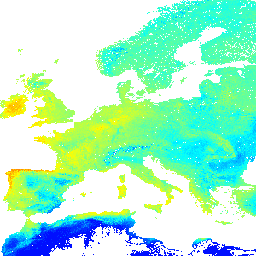
Потенциальная естественная растительность FAPAR, прогнозируемая ежемесячная медиана (на основе PROB-V FAPAR 2014-2017). Описание .
Для доступа к картам и их визуализации вне Earth Engine используйте эту страницу .
Если вы обнаружили ошибку, артефакт или несоответствие на картах LandGIS, или если у вас есть вопрос, пожалуйста, используйте следующие каналы связи:
Группы
Группы
Размер пикселя: 1000 метров (все диапазоны)
| Имя | Единицы | Мин | Макс | Размер пикселя | Описание |
|---|---|---|---|---|---|
jan | Дробь | 0* | 220* | 1000 метров | Январь Потенциальный FAPAR ежемесячно |
feb | Дробь | 0* | 220* | 1000 метров | Февраль. Потенциальный ежемесячный отчет FAPAR. |
mar | Дробь | 0* | 220* | 1000 метров | Потенциальный ежемесячный отчет FAPAR за март |
apr | Дробь | 0* | 220* | 1000 метров | Потенциальный ежемесячный FAPAR за апрель |
may | Дробь | 0* | 220* | 1000 метров | Потенциальный ежемесячный отчет FAPAR за май |
jun | Дробь | 0* | 220* | 1000 метров | Июнь Потенциальный FAPAR ежемесячно |
jul | Дробь | 0* | 220* | 1000 метров | Июль Потенциальный FAPAR ежемесячно |
aug | Дробь | 0* | 220* | 1000 метров | Август Потенциальный FAPAR ежемесячно |
sep | Дробь | 0* | 220* | 1000 метров | Ежемесячный потенциальный отчет FAPAR за сентябрь |
oct | Дробь | 0* | 220* | 1000 метров | Потенциальный ежемесячный отчет FAPAR за октябрь |
nov | Дробь | 0* | 220* | 1000 метров | Ноябрь Потенциальный FAPAR ежемесячно |
dec | Дробь | 0* | 220* | 1000 метров | Декабрь. Потенциальный ежемесячный FAPAR. |
annual | Дробь | 0* | 220* | 1000 метров | Ежегодный потенциальный FAPAR ежемесячно |
annualdiff | Дробь | 0* | 220* | 1000 метров | Потенциальная годовая разница FAPAR ежемесячно |
Условия эксплуатации
Условия эксплуатации
Это удобочитаемое краткое изложение (а не замена) лицензии .
Вы можете свободно: делиться – копировать и распространять материал в любом формате и на любом носителе; адаптировать – перерабатывать, преобразовывать и использовать материал в любых целях, даже в коммерческих.
Данная лицензия действительна для бесплатных культурных произведений. Лицензиар не может отозвать эти права, если вы соблюдаете условия лицензии.
При соблюдении следующих условий: Указание авторства — Вы обязаны указать соответствующее авторство, предоставить ссылку на лицензию и указать, были ли внесены изменения. Вы можете сделать это любым разумным способом, но не таким образом, чтобы создавалось впечатление, что лицензиар одобряет вас или ваше использование.
ShareAlike - Если вы перерабатываете, преобразуете или создаете производные произведения на основе данного материала, вы должны распространять свои результаты на условиях той же лицензии, что и оригинал.
Никаких дополнительных ограничений — Вы не можете применять юридические условия или технологические меры, которые юридически ограничивают других в совершении действий, разрешенных лицензией.
Цитаты
Хенгл Т., Уолш М.Г., Сандерман Дж., Уилер И., Харрисон С.П., Прентис И.К. (2018) Глобальное картирование потенциальной естественной растительности: оценка алгоритмов машинного обучения для оценки потенциала земель. PeerJ Preprints. 10.7287/peerj.preprints.26811v5
DOI
Исследуйте мир с помощью Earth Engine.
Редактор кода (JavaScript)
var dataset = ee.Image('OpenLandMap/PNV/PNV_FAPAR_PROBA-V_D/v01');

var visualization = {
  bands: ['jan'],
  min: 0.0,
  max: 220.0,
  palette: ['0000ff', '00ffff', 'ffff00', 'ff0000']
};

Map.centerObject(dataset);

Map.addLayer(dataset, visualization, 'Potential FAPAR monthly');