Ten zbiór danych dotyczący wilgotności w transformacji Tasseled Cap (TCW) został utworzony przez zastosowanie równań transformacji Tasseled Cap zdefiniowanych w artykule Lobser i Cohen (2007) do obrazów MODIS skorygowanych pod kątem BRDF (MCD43B4). Wynikowe dane zostały uzupełnione zgodnie z metodą opisaną w artykule Weiss i wsp. (2014) w celu wyeliminowania brakujących danych spowodowanych czynnikami takimi jak zachmurzenie. Następnie dane zostały zagregowane w czasie i przestrzeni, aby uzyskać miesięczny produkt o rozdzielczości ok. 5 km.
Ten zbiór danych został opracowany przez Harry’ego Gibsona i Daniela Weissa z Malaria Atlas Project (Big Data Institute, University of Oxford, Wielka Brytania, https://malariaatlas.org/).
Pasma
Rozmiar piksela 5000 metrów
Pasma
Nazwa
Jednostki
Minimum
Maks.
Rozmiar piksela
Opis
Mean
-0,84*
0,96*
metry
Średnia wartość wskaźnika wilgotności Tasseled Cap dla każdego zagregowanego piksela.
FilledProportion
%
0*
100*
metry
Pasek kontroli jakości, który wskazuje odsetek każdego piksela wynikowego, który składał się z danych pierwotnych (w przeciwieństwie do szacunków uzupełniających luki).
Weiss, D.J., P.M. Atkinson, S. Bhatt, B. Mappin, S.I. Hay & P.W. Gething
(2014) An effective approach for gap-filling continental scale remotely
sensed time-series. ISPRS Journal of Photogrammetry and Remote Sensing, 98, 106–118.
Lobser, S.E. & Cohen, W.B. (2007) MODIS tasselled cap: land cover
characteristics expressed through transformed MODIS data. International
Journal of Remote Sensing, 28, 5079-5101.
Ten zbiór danych dotyczący wilgotności w ramach transformacji Tasseled Cap (TCW) został utworzony przez zastosowanie równań transformacji Tasseled Cap zdefiniowanych w artykule Lobser i Cohen (2007) do obrazów MODIS skorygowanych pod kątem BRDF (MCD43B4). Uzyskane dane zostały uzupełnione za pomocą metody opisanej w artykule Weiss i in. (2014) w celu wyeliminowania brakujących danych spowodowanych przez takie czynniki jak zachmurzenie, …
[null,null,[],[[["\u003cp\u003eThis dataset provides monthly Tasseled Cap Wetness (TCW) data from 2001 to 2015, derived from MODIS imagery.\u003c/p\u003e\n"],["\u003cp\u003eIt utilizes a gap-filling technique to minimize missing data caused by cloud cover or other factors.\u003c/p\u003e\n"],["\u003cp\u003eTCW data is presented at a 5km resolution and includes a quality control band indicating the proportion of gap-filled pixels.\u003c/p\u003e\n"],["\u003cp\u003eThe dataset was developed by the Oxford Malaria Atlas Project and is available under a CC-BY-NC-SA-4.0 license.\u003c/p\u003e\n"],["\u003cp\u003eYou can access and analyze this dataset using Google Earth Engine.\u003c/p\u003e\n"]]],["The dataset provides gap-filled Tasseled Cap Wetness (TCW) data from 2001 to 2015, with a monthly cadence and 5km pixel size. It was created by the Oxford Malaria Atlas Project using MODIS imagery and gap-filling techniques. The data includes mean TCW values and the proportion of raw data per pixel. It is accessible via Google Earth Engine using the code `ee.ImageCollection(\"Oxford/MAP/TCW_5km_Monthly\")` and is licensed under CC-BY-NC-SA-4.0.\n"],null,["# Oxford MAP TCW: Malaria Atlas Project Gap-Filled Tasseled Cap Wetness\n\nDataset Availability\n: 2001-02-01T00:00:00Z--2015-01-01T00:00:00Z\n\nDataset Provider\n:\n\n\n [Oxford Malaria Atlas Project](https://www.bdi.ox.ac.uk/research/malaria-atlas-project)\n\nCadence\n: 1 Month\n\nTags\n:\n [map](/earth-engine/datasets/tags/map) [oxford](/earth-engine/datasets/tags/oxford) [tasseled-cap](/earth-engine/datasets/tags/tasseled-cap) [tcb](/earth-engine/datasets/tags/tcb) [vegetation-indices](/earth-engine/datasets/tags/vegetation-indices) \nwetness \n\n#### Description\n\nThis gap-filled Tasseled Cap Wetness (TCW) dataset was created by applying\nthe tasseled-cap equations defined in Lobser and Cohen (2007) to\nMODIS BRDF-corrected imagery (MCD43B4). The resulting data were\ngap-filled using the approach outlined in Weiss et al. (2014) to eliminate\nmissing data caused by factors such as cloud cover, and then the data were\naggregated temporally and spatially to produce the monthly ≈5km product.\n\nThis dataset was produced by Harry Gibson and Daniel Weiss of the\nMalaria Atlas Project (Big Data Institute, University of Oxford,\nUnited Kingdom, \u003chttps://malariaatlas.org/\u003e).\n\n### Bands\n\n\n**Pixel Size**\n\n5000 meters\n\n**Bands**\n\n| Name | Units | Min | Max | Pixel Size | Description |\n|--------------------|-------|---------|--------|------------|---------------------------------------------------------------------------------------------------------------------------------------------------|\n| `Mean` | | -0.84\\* | 0.96\\* | meters | The mean value of Tasseled Cap Wetness for each aggregated pixel. |\n| `FilledProportion` | % | 0\\* | 100\\* | meters | A quality control band that indicates the percentage of each resulting pixel that was comprised of raw data (as opposed to gap-filled estimates). |\n\n\\* estimated min or max value\n\n### Terms of Use\n\n**Terms of Use**\n\n[CC-BY-NC-SA-4.0](https://spdx.org/licenses/CC-BY-NC-SA-4.0.html)\n\n### Citations\n\nCitations:\n\n- Weiss, D.J., P.M. Atkinson, S. Bhatt, B. Mappin, S.I. Hay \\& P.W. Gething\n (2014) An effective approach for gap-filling continental scale remotely\n sensed time-series. ISPRS Journal of Photogrammetry and Remote Sensing,\n 98, 106-118.\n- Lobser, S.E. \\& Cohen, W.B. (2007) MODIS tasselled cap: land cover\n characteristics expressed through transformed MODIS data. International\n Journal of Remote Sensing, 28, 5079-5101.\n\n### Explore with Earth Engine\n\n| **Important:** Earth Engine is a platform for petabyte-scale scientific analysis and visualization of geospatial datasets, both for public benefit and for business and government users. Earth Engine is free to use for research, education, and nonprofit use. To get started, please [register for Earth Engine access.](https://console.cloud.google.com/earth-engine)\n\n### Code Editor (JavaScript)\n\n```javascript\n
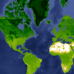
var dataset = ee.ImageCollection('Oxford/MAP/TCW_5km_Monthly')\n .filter(ee.Filter.date('2013-01-01', '2013-12-31'));\nvar tcw = dataset.select('Mean');\nvar tcwVis = {\n min: -0.6,\n max: 0.5,\n palette: [\n 'ffffff', 'fcd163', '99b718', '66a000', '3e8601', '207401', '056201',\n '004c00', '011301'\n ],\n};\nMap.setCenter(-44.65, 22.59, 2);\nMap.addLayer(tcw, tcwVis, 'TCW');\n```\n[Open in Code Editor](https://code.earthengine.google.com/?scriptPath=Examples:Datasets/Oxford/Oxford_MAP_TCW_5km_Monthly) \n[Oxford MAP TCW: Malaria Atlas Project Gap-Filled Tasseled Cap Wetness](/earth-engine/datasets/catalog/Oxford_MAP_TCW_5km_Monthly) \nThis gap-filled Tasseled Cap Wetness (TCW) dataset was created by applying the tasseled-cap equations defined in Lobser and Cohen (2007) to MODIS BRDF-corrected imagery (MCD43B4). The resulting data were gap-filled using the approach outlined in Weiss et al. (2014) to eliminate missing data caused by factors such as cloud cover, ... \nOxford/MAP/TCW_5km_Monthly, map,oxford,tasseled-cap,tcb,vegetation-indices \n2001-02-01T00:00:00Z/2015-01-01T00:00:00Z \n-90 -180 90 180 \nGoogle Earth Engine \nhttps://developers.google.com/earth-engine/datasets\n\n- [](https://doi.org/https://www.bdi.ox.ac.uk/research/malaria-atlas-project)\n- [](https://doi.org/https://developers.google.com/earth-engine/datasets/catalog/Oxford_MAP_TCW_5km_Monthly)"]]