- ডেটাসেট উপলব্ধতা
- 2019-01-01T00:00:00Z–2020-01-01T00:00:00Z
- ডেটাসেট প্রদানকারী
- ম্যালেরিয়া অ্যাটলাস প্রকল্প
- ট্যাগ
বর্ণনা
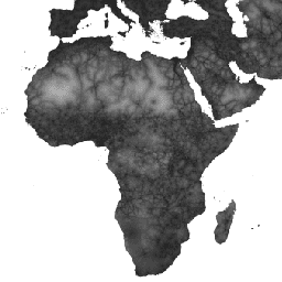
এই গ্লোবাল অ্যাক্সেসিবিলিটি ম্যাপটি 2019 সালের জন্য 85 ডিগ্রি উত্তর এবং 60 ডিগ্রি দক্ষিণের মধ্যে সমস্ত এলাকার জন্য নিকটতম হাসপাতাল বা ক্লিনিকে ভূমি-ভিত্তিক ভ্রমণের সময় (মিনিটের মধ্যে) গণনা করে৷ এটিতে "শুধুমাত্র হাঁটা" ভ্রমণের সময়ও অন্তর্ভুক্ত রয়েছে, যা কেবলমাত্র পরিবহনের অ-মোটরাইজড মাধ্যম ব্যবহার করে৷
ওপেনস্ট্রিটম্যাপ, গুগল ম্যাপস, এবং একাডেমিক গবেষকদের দ্বারা চলমান প্রধান ডেটা সংগ্রহের প্রচেষ্টাগুলিকে আজ পর্যন্ত স্বাস্থ্যসেবা সুবিধার অবস্থানগুলির সবচেয়ে সম্পূর্ণ সংগ্রহ কম্পাইল করার জন্য ব্যবহার করা হয়েছে৷ এই মানচিত্রটি এমএপি (অক্সফোর্ড বিশ্ববিদ্যালয়), টেলিথন কিডস ইনস্টিটিউট (পার্থ, অস্ট্রেলিয়া), গুগল এবং ইউনিভার্সিটি অফ টুয়েন্টি, নেদারল্যান্ডের মধ্যে সহযোগিতার মাধ্যমে তৈরি করা হয়েছে।
এই প্রকল্পটি ওয়েইস এট আল 2018 ( doi:10.1038/nature25181 ) দ্বারা প্রকাশিত পূর্ববর্তী কাজের উপর ভিত্তি করে তৈরি করা হয়েছে। Weiss et al (2018) রাস্তাগুলির জন্য ডেটাসেটগুলি ব্যবহার করেছেন (ওপেন স্ট্রিট ম্যাপ এবং Google রাস্তার ডেটাসেটের প্রথমবারের মতো বিশ্বব্যাপী ব্যবহার সমন্বিত), রেলপথ, নদী, হ্রদ, মহাসাগর, টপোগ্রাফিক অবস্থা (ঢাল এবং উচ্চতা), ল্যান্ডকভারের ধরন এবং জাতীয় সীমানা। এই ডেটাসেটগুলিকে সেই ধরণের প্রতিটি পিক্সেল অতিক্রম করার জন্য সময়ের পরিপ্রেক্ষিতে একটি গতি বা ভ্রমণের গতি বরাদ্দ করা হয়েছিল। ডেটাসেটগুলিকে তারপর একটি "ঘর্ষণ পৃষ্ঠ" তৈরি করতে একত্রিত করা হয়েছিল: একটি মানচিত্র যেখানে প্রতিটি পিক্সেলকে সেই পিক্সেলের মধ্যে ঘটতে থাকা প্রকারের উপর ভিত্তি করে ভ্রমণের একটি নামমাত্র সামগ্রিক গতি বরাদ্দ করা হয়। বর্তমান প্রকল্পের জন্য, OSM রাস্তার ডেটার মধ্যে সাম্প্রতিক উন্নতিগুলিকে অন্তর্ভুক্ত করার জন্য একটি আপডেট করা ঘর্ষণ পৃষ্ঠ তৈরি করা হয়েছিল৷
সর্বনিম্ন-খরচ-পাথ অ্যালগরিদমগুলি (গুগল আর্থ ইঞ্জিনে চালিত এবং উচ্চ-অক্ষাংশ অঞ্চলের জন্য, R-এ) এই ঘর্ষণ পৃষ্ঠের সাথে ব্যবহার করা হয়েছিল সমস্ত অবস্থান থেকে নিকটতম (সময়ে) স্বাস্থ্যসেবা সুবিধায় ভ্রমণের সময় গণনা করতে। স্বাস্থ্যসেবা সুবিধার ডেটাসেট দুটি বৃহত্তম গ্লোবাল ডাটাবেস থেকে অবস্থান ডেটা ব্যবহার করেছে: (1) OSM ডেটা যা একত্রিত করা হয়েছিল এবং www.healthsites.io এ ডাউনলোডের জন্য উপলব্ধ করা হয়েছিল; এবং (2) ডেটা গুগল ম্যাপ থেকে বের করা হয়েছে। বিশ্বব্যাপী ডেটাসেটগুলি মহাদেশীয়-স্কেল সুবিধার অবস্থানগুলির সাথে বর্ধিত করা হয়েছিল যা সম্প্রতি আফ্রিকা এবং অস্ট্রেলিয়ার জন্য প্রকাশিত হয়েছিল। ডেটা উত্সগুলির মধ্যে তুলনা করার সুবিধার্থে, শুধুমাত্র হাসপাতাল এবং ক্লিনিক হিসাবে সংজ্ঞায়িত সুবিধাগুলি ব্যবহার করা হয়েছিল। একই পিক্সেলের মধ্যে পাওয়া একাধিক পয়েন্ট পৃথিবীর পৃষ্ঠের নির্বাচিত গ্রিডেড উপস্থাপনা দ্বারা সংজ্ঞায়িত বিশ্লেষণের রেজোলিউশনের সাথে মেলে। ফলস্বরূপ অ্যাক্সেসিবিলিটি মানচিত্রের প্রতিটি পিক্সেল এইভাবে সেই অবস্থান থেকে একটি হাসপাতাল বা ক্লিনিকে মডেল করা সবচেয়ে কম সময় (মিনিটের মধ্যে) উপস্থাপন করে।
উত্স ডেটাসেট ক্রেডিটগুলি সহগামী কাগজে বর্ণনা করা হয়েছে৷
ব্যান্ড
পিক্সেল সাইজ
927.67 মিটার
ব্যান্ড
| নাম | ইউনিট | মিন | সর্বোচ্চ | পিক্সেল সাইজ | বর্ণনা |
|---|---|---|---|---|---|
accessibility | মিনিট | 0 | 41504.1 | মিটার | নিকটস্থ হাসপাতাল বা ক্লিনিকে ভ্রমণের সময়। |
accessibility_walking_only | মিনিট | 0 | 138893 | মিটার | অ-মোটর চালিত পরিবহন ব্যবহার করে নিকটস্থ হাসপাতাল বা ক্লিনিকে ভ্রমণের সময়। |
ব্যবহারের শর্তাবলী
ব্যবহারের শর্তাবলী
এই কাজটি ক্রিয়েটিভ কমন্স অ্যাট্রিবিউশন 4.0 আন্তর্জাতিক লাইসেন্সের অধীনে লাইসেন্সপ্রাপ্ত।
উদ্ধৃতি
ডিজে ওয়েইস, এ. নেলসন, সিএ ভার্গাস-রুইজ, কে. গ্লিগোরিচ, এস. বাভাদেকর, ই. গ্যাব্রিলোভিচ, এ. বার্তোজি-ভিলা, জে. রোজিয়ের, এইচএস গিবসন, টি. শেকেল, সি. কামাথ, এ. লিবার, কে. শুলম্যান, ওয়াই শাও, ভি. কার্কাডি ই, এস, কে, রুর্কমি, এস. ক্যামেরন, কেই ব্যাটল, এস ভাট, পিডব্লিউ গেথিং। স্বাস্থ্যসেবা সুবিধাগুলিতে ভ্রমণের সময়ের বৈশ্বিক মানচিত্র। নেচার মেডিসিন (2020)।
আর্থ ইঞ্জিন দিয়ে অন্বেষণ করুন
কোড এডিটর (জাভাস্ক্রিপ্ট)
var dataset = ee.Image('Oxford/MAP/accessibility_to_healthcare_2019');
var accessibility = dataset.select('accessibility');
var accessibilityVis = {
  min: 0.0,
  max: 41556.0,
  gamma: 4.0,
};
Map.setCenter(18.98, 6.66, 2);
Map.addLayer(accessibility, accessibilityVis, 'Accessibility');