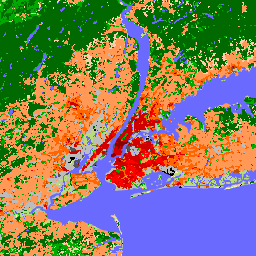
מאז שהוצגו בשנת 2012, אזורי אקלים מקומיים (LCZ) הפכו לסטנדרט חדש לאפיון נופים עירוניים, והם מספקים גישה הוליסטית לסיווג שמתחשבת בכיסוי קרקע בקנה מידה מיקרו ובמאפיינים פיזיים קשורים.
המפה הגלובלית הזו של אזורי אקלים מקומיים, בגודל פיקסל של 100 מ' ומייצגת את שנת 2018, נגזרת ממערכי נתונים רבים של תצפיות על כדור הארץ ומתוויות של סיווגים של אזורי אקלים מקומיים שנוצרו על ידי מומחים. הפס המומלץ לרוב המשתמשים הוא LCZ_Filter. סיווג נוסף, LCZ, מסופק רק כי הוא משמש לחישוב של סיווג LCZ_Probability.
סיווג LCZ משלים סיווגים אחרים של שימוש בקרקע או כיסוי קרקע, כי הוא מתמקד בסוגי נוף עירוני וכפרי שאפשר לתאר באמצעות כל אחת מ-17 הקטגוריות בסיווג LCZ. מתוך 17 הסיווגים של LCZ, 10 משקפים את הסביבה הבנויה, וכל סוג של LCZ משויך לתיאורים מספריים כלליים של פרמטרים מרכזיים של צל העצים באזורים עירוניים, שחשובים למודל של תגובות אטמוספריות לעיור. בנוסף, מכיוון שאזורים אקלימיים מקומיים תוכננו במקור כמסגרת חדשה למחקרים על אי חום עירוני, הם כוללים גם קבוצה מוגבלת (7) של סיווגים של כיסוי קרקע 'טבעי' שאפשר להשתמש בהם כאזורי 'בקרה' או 'התייחסות טבעית'.
מכיוון ששבעת הסיווגים הטבעיים האלה בתוכנית LCZ לא יכולים לתאר את המגוון של המערכות האקולוגיות הטבעיות הקיימות בעולם, אנחנו ממליצים למשתמשים – אם נדרש – לשלב את הסיווגים של LCZ עם כל מוצר אחר של כיסוי קרקע שמספק מגוון רחב יותר של סיווגים טבעיים של כיסוי קרקע.
מפת אזורי האקלים המקומיים הגלובלית הגולמית שמבוססת על פיקסלים עם סיווגים של אזורי אקלים מקומיים
LCZ_Filter
מטרים
מפת אזורי האקלים המומלצת עם סיווגים של אזורי אקלים. תוויות LCZ מתקבלות אחרי שמחילים את המסנן הגאוסי המורפולוגי שמתואר במאמר של Demuzere et al. (2020)
LCZ_Probability
%
מטרים
שכבת הסתברות שמזהה באיזו תדירות נבחרה ה-LCZ המודאלית לכל פיקסל (למשל, הסתברות של 60% פירושה שסווגו 30 פעמים מתוך 50 מודלים של LCZ). זוהי הסתברות שמבוססת על פיקסלים ונגזרת משכבת ה-LCZ
Demuzere M.; Kittner J.; Martilli A.; Mills, G.; Moede, C.; Stewart, I.D.; van Vliet, J.; Bechtel, B.
מפה גלובלית של אזורי אקלים מקומיים לתמיכה במודלים של מערכת כדור הארץ ובמדעי הסביבה בקנה מידה עירוני.
Earth System Science Data 2022, 14 Volume 8: 3835-3873.
doi:10.5194/essd-14-3835-2022
מאז שהוצגו בשנת 2012, אזורי אקלים מקומיים (LCZ) הפכו לתקן חדש לאפיון נופים עירוניים, והם מספקים גישה הוליסטית לסיווג שמתחשבת בכיסוי הקרקע בקנה מידה מיקרו ובמאפיינים הפיזיים שקשורים אליו. המפה הגלובלית הזו של אזורי אקלים מקומיים, בגודל פיקסל של 100 מ' ומייצגת את השנה הנומינלית …
[null,null,[],[[["\u003cp\u003eThis dataset provides a global map of Local Climate Zones (LCZs) at a 100m resolution for the nominal year 2018.\u003c/p\u003e\n"],["\u003cp\u003eLCZs offer a standardized classification of urban landscapes, incorporating micro-scale land cover and physical properties for climate studies.\u003c/p\u003e\n"],["\u003cp\u003eThe dataset includes 17 LCZ classes, representing both built environments (10) and natural land cover types (7).\u003c/p\u003e\n"],["\u003cp\u003eThe 'LCZ_Filter' band is recommended for general use, offering a morphologically filtered LCZ classification.\u003c/p\u003e\n"],["\u003cp\u003eUsers may combine the built LCZ classes with other land cover products for more detailed analyses of natural ecosystems.\u003c/p\u003e\n"]]],[],null,["# Global map of Local Climate Zones, latest version\n\nDataset Availability\n: 2018-01-01T00:00:00Z--2019-01-01T00:00:00Z\n\nDataset Provider\n:\n\n\n [Bochum Urban Climate Lab](https://lcz-generator.rub.de/global-lcz-map)\n\nTags\n:\n[climate](/earth-engine/datasets/tags/climate) [landcover](/earth-engine/datasets/tags/landcover) [landuse-landcover](/earth-engine/datasets/tags/landuse-landcover) [urban](/earth-engine/datasets/tags/urban) \n\n#### Description\n\nSince their introduction in 2012, Local Climate Zones (LCZs) emerged as\na new standard for characterizing urban landscapes, providing a holistic\nclassification approach that takes into account micro-scale land-cover and\nassociated physical properties.\n\nThis global map of Local Climate Zones, at 100m pixel size and\nrepresentative for the nominal year 2018, is derived from multiple earth\nobservation datasets and expert LCZ class labels. LCZ_Filter is the\nrecommended band for most users. The other classification band, LCZ, is\nonly provided as it is used to calculate the LCZ_Probability band.\n\nThe LCZ scheme complements other land use / land cover schemes by\nits focus on urban and rural landscape types, which can be described by\nany of the 17 classes in the LCZ scheme. Out of the 17 LCZ classes, 10\nreflect the 'built' environment, and each LCZ type is associated with\ngeneric numerical descriptions of key urban canopy parameters critical to\nmodel atmospheric responses to urbanisation. In addition, since LCZs were\noriginally designed as a new framework for urban heat island studies, they\nalso contain a limited set (7) of 'natural' land-cover classes that can be\nused as 'control' or 'natural reference' areas.\n\nAs these seven natural classes in the LCZ scheme can not capture the\nheterogeneity of the world's existing natural ecosystems, we advise\nusers - if required - to combine the built LCZ classes with any other\nland-cover product that provides a wider range of natural land-cover\nclasses.\n\nSee also:\n\n- [LCZ Typology](https://doi.org/10.1175/BAMS-D-11-00019.1)\n\n- [Global map of LCZs - paper](https://doi.org/10.5194/essd-14-3835-2022)\n\n- [Global map of LCZs - dataset](https://doi.org/10.5281/zenodo.6364593)\n\n- [LCZ Gaussian filtering](https://doi.org/10.1038/s41597-020-00605-z)\n\n### Bands\n\n\n**Pixel Size**\n\n100 meters\n\n**Bands**\n\n| Name | Units | Pixel Size | Description |\n|-------------------|-------|------------|----------------------------------------------------------------------------------------------------------------------------------------------------------------------------------------------------------------------------------------------------|\n| `LCZ` | | meters | The raw, pixel-based global LCZ map with LCZ classes |\n| `LCZ_Filter` | | meters | The recommended global LCZ map with LCZ classes. LCZ labels are obtained after applying the morphological Gaussian filter described in Demuzere et al. (2020) |\n| `LCZ_Probability` | % | meters | A probability layer that identifies how often the modal LCZ was chosen per pixel (e.g. a probability of 60% means that the modal LCZ class was mapped 30 times out of 50 LCZ models). This is a pixel-based probability derived from the LCZ layer |\n\n**LCZ Class Table**\n\n| Value | Color | Description |\n|-------|---------|----------------------------|\n| 1 | #8c0000 | Compact highrise |\n| 2 | #d10000 | Compact midrise |\n| 3 | #ff0000 | Compact lowrise |\n| 4 | #bf4d00 | Open highrise |\n| 5 | #ff6600 | Open midrise |\n| 6 | #ff9955 | Open lowrise |\n| 7 | #faee05 | Lightweight lowrise |\n| 8 | #bcbcbc | Large lowrise |\n| 9 | #ffccaa | Sparsely built |\n| 10 | #555555 | Heavy industry |\n| 11 | #006a00 | Dense Trees (LCZ A) |\n| 12 | #00aa00 | Scattered Trees (LCZ B) |\n| 13 | #648525 | Bush, scrub (LCZ C) |\n| 14 | #b9db79 | Low plants (LCZ D) |\n| 15 | #000000 | Bare rock or paved (LCZ E) |\n| 16 | #fbf7ae | Bare soil or sand (LCZ F) |\n| 17 | #6a6aff | Water (LCZ G) |\n\n**LCZ_Filter Class Table**\n\n| Value | Color | Description |\n|-------|---------|----------------------------|\n| 1 | #8c0000 | Compact highrise |\n| 2 | #d10000 | Compact midrise |\n| 3 | #ff0000 | Compact lowrise |\n| 4 | #bf4d00 | Open highrise |\n| 5 | #ff6600 | Open midrise |\n| 6 | #ff9955 | Open lowrise |\n| 7 | #faee05 | Lightweight lowrise |\n| 8 | #bcbcbc | Large lowrise |\n| 9 | #ffccaa | Sparsely built |\n| 10 | #555555 | Heavy industry |\n| 11 | #006a00 | Dense Trees (LCZ A) |\n| 12 | #00aa00 | Scattered Trees (LCZ B) |\n| 13 | #648525 | Bush, scrub (LCZ C) |\n| 14 | #b9db79 | Low plants (LCZ D) |\n| 15 | #000000 | Bare rock or paved (LCZ E) |\n| 16 | #fbf7ae | Bare soil or sand (LCZ F) |\n| 17 | #6a6aff | Water (LCZ G) |\n\n### Terms of Use\n\n**Terms of Use**\n\n[CC-BY-4.0](https://spdx.org/licenses/CC-BY-4.0.html)\n\n### Citations\n\nCitations:\n\n- Demuzere M.; Kittner J.; Martilli A.; Mills, G.; Moede, C.; Stewart, I.D.; van Vliet, J.; Bechtel, B.\n A global map of local climate zones to support earth system modelling and urban-scale environmental science.\n Earth System Science Data 2022, 14 Volume 8: 3835-3873.\n [doi:10.5194/essd-14-3835-2022](https://doi.org/10.5194/essd-14-3835-2022)\n\n### DOIs\n\n- \u003chttps://doi.org/10.5281/zenodo.6364593\u003e\n\n### Explore with Earth Engine\n\n| **Important:** Earth Engine is a platform for petabyte-scale scientific analysis and visualization of geospatial datasets, both for public benefit and for business and government users. Earth Engine is free to use for research, education, and nonprofit use. To get started, please [register for Earth Engine access.](https://console.cloud.google.com/earth-engine)\n\n### Code Editor (JavaScript)\n\n```javascript\nvar dataset = ee.ImageCollection('RUB/RUBCLIM/LCZ/global_lcz_map/latest')\n .mosaic();\n\nvar visualization = {\n bands: ['LCZ_Filter'],\n min: 1,\n max: 17,\n palette: [\n '8c0000','d10000','ff0000','bf4d00','ff6600',\n 'ff9955','faee05','bcbcbc','ffccaa','555555',\n '006a00','00aa00','648525','b9db79','000000',\n 'fbf7ae','6a6aff'\n ]\n};\n\nMap.setCenter(7.26, 51.44, 6);\nMap.addLayer(dataset, visualization, 'LCZ_Filter');\n```\n[Open in Code Editor](https://code.earthengine.google.com/?scriptPath=Examples:Datasets/RUB/RUB_RUBCLIM_LCZ_global_lcz_map_latest) \n[Global map of Local Climate Zones, latest version](/earth-engine/datasets/catalog/RUB_RUBCLIM_LCZ_global_lcz_map_latest) \nSince their introduction in 2012, Local Climate Zones (LCZs) emerged as a new standard for characterizing urban landscapes, providing a holistic classification approach that takes into account micro-scale land-cover and associated physical properties. This global map of Local Climate Zones, at 100m pixel size and representative for the nominal year ... \nRUB/RUBCLIM/LCZ/global_lcz_map/latest, climate,landcover,landuse-landcover,urban \n2018-01-01T00:00:00Z/2019-01-01T00:00:00Z \n-90 -180 90 180 \nGoogle Earth Engine \nhttps://developers.google.com/earth-engine/datasets\n\n- [https://doi.org/10.5281/zenodo.6364593](https://doi.org/https://lcz-generator.rub.de/global-lcz-map)\n- [https://doi.org/10.5281/zenodo.6364593](https://doi.org/https://developers.google.com/earth-engine/datasets/catalog/RUB_RUBCLIM_LCZ_global_lcz_map_latest)"]]