- Dostępność zbioru danych
- 2018-01-01T00:00:00Z–2019-01-01T00:00:00Z
- Dostawca zbioru danych
- Bochum Urban Climate Lab
- Tagi
Opis
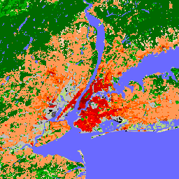
Od czasu wprowadzenia w 2012 r. lokalne strefy klimatyczne (LCZ) stały się nowym standardem charakteryzowania krajobrazów miejskich, zapewniając holistyczne podejście do klasyfikacji, które uwzględnia pokrycie terenu w mikroskali i powiązane z nim właściwości fizyczne.
Ta globalna mapa lokalnych stref klimatycznych o rozdzielczości 100 m na piksel, reprezentatywna dla roku 2018, została utworzona na podstawie wielu zbiorów danych obserwacji Ziemi i etykiet klas LCZ od ekspertów. LCZ_Filter to zalecane pasmo dla większości użytkowników. Druga klasyfikacja, LCZ, jest podawana tylko dlatego, że jest używana do obliczania pasma LCZ_Probability.
System LCZ uzupełnia inne systemy klasyfikacji użytkowania i pokrycia terenu, ponieważ koncentruje się na typach krajobrazu miejskiego i wiejskiego, które można opisać za pomocą dowolnej z 17 klas w systemie LCZ. Z 17 klas LCZ 10 odzwierciedla środowisko „zabudowane”, a każdy typ LCZ jest powiązany z ogólnymi opisami numerycznymi kluczowych parametrów pokrywy miejskiej, które mają kluczowe znaczenie dla modelowania reakcji atmosfery na urbanizację. Oprócz tego, ponieważ strefy klimatu lokalnego zostały pierwotnie zaprojektowane jako nowe ramy badań miejskich wysp ciepła, zawierają one również ograniczony zestaw (7) „naturalnych” klas pokrycia terenu, które można wykorzystać jako obszary „kontrolne” lub „naturalne odniesienia”.
Ponieważ te 7 naturalnych klas w schemacie LCZ nie jest w stanie odzwierciedlić różnorodności istniejących na świecie ekosystemów naturalnych, zalecamy użytkownikom, aby w razie potrzeby łączyli klasy LCZ dotyczące obszarów zabudowanych z dowolnym innym produktem dotyczącym pokrycia terenu, który zapewnia szerszy zakres naturalnych klas pokrycia terenu.
Zobacz także:
Pasma
Rozmiar piksela
100 metrów
Pasma
| Nazwa | Jednostki | Rozmiar piksela | Opis |
|---|---|---|---|
LCZ |
metry | Surowa, globalna mapa LCZ oparta na pikselach z klasami LCZ |
|
LCZ_Filter |
metry | Zalecana globalna mapa LCZ z klasami LCZ. Etykiety LCZ są uzyskiwane po zastosowaniu morfologicznego filtra Gaussa opisanego w artykule Demuzere i in. (2020). |
|
LCZ_Probability |
% | metry | Warstwa prawdopodobieństwa, która określa, jak często modalna strefa LCZ była wybierana dla każdego piksela (np. prawdopodobieństwo 60% oznacza, że modalna klasa LCZ została zmapowana 30 razy na 50 modeli LCZ). Jest to prawdopodobieństwo oparte na pikselach, które pochodzi z warstwy LCZ. |
Tabela klas LCZ
| Wartość | Kolor | Opis |
|---|---|---|
| 1 | #8c0000 | Kompaktowy wieżowiec |
| 2 | #d10000 | Kompaktowy midrise |
| 3 | #ff0000 | Kompaktowy niski |
| 4 | #bf4d00 | Otwórz wieżowiec |
| 5 | #ff6600 | Open midrise |
| 6 | #ff9955 | Open lowrise |
| 7 | #faee05 | Lekkie, z niskim stanem |
| 8 | #bcbcbc | Duży budynek niski |
| 9 | #ffccaa | Rzadko zabudowane |
| 10 | #555555 | Przemysł ciężki |
| 11 | #006a00 | Gęste drzewa (LCZ A) |
| 12 | #00aa00 | Rozproszone drzewa (LCZ B) |
| 13 | #648525 | Krzewy, zarośla (LCZ C) |
| 14 | #b9db79 | Niska roślinność (LCZ D) |
| 15 | #000000 | Goła skała lub utwardzona (LCZ E) |
| 16 | #fbf7ae | Goła ziemia lub piasek (LCZ F) |
| 17 | #6a6aff | Woda (LCZ G) |
LCZ_Filter Class Table
| Wartość | Kolor | Opis |
|---|---|---|
| 1 | #8c0000 | Kompaktowy wieżowiec |
| 2 | #d10000 | Kompaktowy midrise |
| 3 | #ff0000 | Kompaktowy niski |
| 4 | #bf4d00 | Otwórz wieżowiec |
| 5 | #ff6600 | Open midrise |
| 6 | #ff9955 | Open lowrise |
| 7 | #faee05 | Lekkie, z niskim stanem |
| 8 | #bcbcbc | Duży budynek niski |
| 9 | #ffccaa | Rzadko zabudowane |
| 10 | #555555 | Przemysł ciężki |
| 11 | #006a00 | Gęste drzewa (LCZ A) |
| 12 | #00aa00 | Rozproszone drzewa (LCZ B) |
| 13 | #648525 | Krzewy, zarośla (LCZ C) |
| 14 | #b9db79 | Niska roślinność (LCZ D) |
| 15 | #000000 | Goła skała lub utwardzona (LCZ E) |
| 16 | #fbf7ae | Goła ziemia lub piasek (LCZ F) |
| 17 | #6a6aff | Woda (LCZ G) |
Warunki korzystania z usługi
Warunki korzystania z usługi
Cytaty
Demuzere M.; Kittner J.; Martilli A.; Mills, G.; Moede, C.; Stewart, I.D.; van Vliet, J.; Bechtel, B. Globalna mapa lokalnych stref klimatycznych, która wspiera modelowanie systemu ziemskiego i badania środowiskowe na skalę miejską. Earth System Science Data 2022, 14 Volume 8: 3835-3873. doi:10.5194/essd-14-3835-2022
DOI
Odkrywanie za pomocą Earth Engine
Edytor kodu (JavaScript)
var dataset = ee.ImageCollection('RUB/RUBCLIM/LCZ/global_lcz_map/latest')
            .mosaic();

var visualization = {
  bands: ['LCZ_Filter'],
  min: 1,
  max: 17,
  palette: [
    '8c0000','d10000','ff0000','bf4d00','ff6600',
    'ff9955','faee05','bcbcbc','ffccaa','555555',
    '006a00','00aa00','648525','b9db79','000000',
    'fbf7ae','6a6aff'
    ]
};

Map.setCenter(7.26, 51.44, 6);
Map.addLayer(dataset, visualization, 'LCZ_Filter');