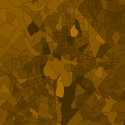
Amerykańskie Biuro Spisu Ludności regularnie udostępnia geobazę danych o nazwie TIGER. Ta tabela zawiera wartości z profilu demograficznego 1 z 2010 r. agregowane według okręgu spisowego. Obszary spisowe bardzo się różnią, ale na obszarach miejskich są w przybliżeniu równoważne dzielnicy. Zawiera około 74 tys. wielokątów obejmujących Stany Zjednoczone, Dystrykt Kolumbii, Portoryko i obszary wyspiarskie.
Każdy okręg zawiera też atrybuty z sumami pomiarów populacji DP1, które przecinają jego granicę. Kolumny mają taką samą nazwę jak kolumna shortname w tabeli wyszukiwania DP1.
Schemat tabeli
Schemat tabeli
Nazwa
Typ
Opis
aland10
LICZBA ZMIENNOPRZECINKOWA O PODWÓJNEJ PRECYZJI
Powierzchnia
awater10
LICZBA ZMIENNOPRZECINKOWA O PODWÓJNEJ PRECYZJI
Obszar wodny
geoid10
CIĄG ZNAKÓW
Identyfikator okręgu spisowego: połączenie kodu FIPS stanu, kodu FIPS hrabstwa i kodu okręgu spisowego.
intptlat10
CIĄG ZNAKÓW
Szerokość geograficzna punktu wewnętrznego
intptlon10
CIĄG ZNAKÓW
Długość geograficzna punktu wewnętrznego
namelsad10
CIĄG ZNAKÓW
Opis obszaru prawnego lub statystycznego oraz nazwa okręgu spisowego
shape_area
LICZBA ZMIENNOPRZECINKOWA O PODWÓJNEJ PRECYZJI
Powierzchnia w stopniach kwadratowych
shape_leng
LICZBA ZMIENNOPRZECINKOWA O PODWÓJNEJ PRECYZJI
Granica w stopniach
Warunki korzystania z usługi
Amerykańskie Biuro Spisu Ludności udostępnia niektóre ze swoich publicznych danych w formacie czytelnym dla maszyn za pomocą interfejsu API. Wszystkie treści, dokumentacja, kod i materiały powiązane udostępniane Ci za pomocą interfejsu API podlegają niniejszym warunkom.
Cytaty
Cytowania:
W przypadku tworzenia raportów, publikacji, nowych zbiorów danych, produktów pochodnych lub usług na podstawie zbioru danych użytkownicy powinni cytować US Census Bureau.
Amerykańskie Biuro Spisu Ludności regularnie udostępnia bazę danych geograficznych o nazwie TIGER. Ta tabela zawiera wartości z profilu demograficznego 1 z 2010 r. agregowane według okręgu spisowego. Obszary spisowe bardzo się różnią, ale na obszarach miejskich są w przybliżeniu równoważne dzielnicy. Zawiera około 74 tys. wielokątów obejmujących Stany Zjednoczone, …
[null,null,[],[[["\u003cp\u003eThe TIGER/2010/Tracts_DP1 dataset provides 2010 US Census Demographic Profile 1 data aggregated by census tract.\u003c/p\u003e\n"],["\u003cp\u003eIt includes approximately 74,000 polygon features covering the United States, District of Columbia, Puerto Rico, and Island Areas.\u003c/p\u003e\n"],["\u003cp\u003eData is provided by the United States Census Bureau and is available for the date 2010-01-01.\u003c/p\u003e\n"],["\u003cp\u003eCensus tracts represent relatively small, homogenous neighborhood-sized areas, although their size can vary.\u003c/p\u003e\n"],["\u003cp\u003eThe dataset includes demographic attributes such as population counts and can be accessed and analyzed within Google Earth Engine.\u003c/p\u003e\n"]]],[],null,["# TIGER: US Census Tracts Demographic - Profile 1\n\nDataset Availability\n: 2010-01-01T00:00:00Z--2010-01-02T00:00:00Z\n\nDataset Provider\n:\n\n\n [United States Census Bureau](https://www.census.gov/programs-surveys/geography/guidance/tiger-data-products-guide.html)\n\nTags\n:\n [census](/earth-engine/datasets/tags/census) [infrastructure-boundaries](/earth-engine/datasets/tags/infrastructure-boundaries) [table](/earth-engine/datasets/tags/table) [tiger](/earth-engine/datasets/tags/tiger) [us](/earth-engine/datasets/tags/us) \n demographic \n human \nsocial \n\n#### Description\n\nThe United States Census Bureau regularly releases\na geodatabase named TIGER. This table contains the 2010 census\nDemographic Profile 1 values aggregated by census tract. Tract\nareas vary tremendously, but in urban areas are roughly equivalent\nto a neighborhood. There are about 74,000 polygon features covering\nthe United States, the District of Columbia, Puerto Rico, and\nthe [Island areas](https://www.census.gov/data/tables/2010/dec/2010-island-areas.html).\n\nFor full technical details on all TIGER 2010 products, see\nthe [TIGER technical documentation](https://www2.census.gov/geo/pdfs/maps-data/data/tiger/tgrshp2010/TGRSHP10SF1.pdf).\n\nEach tract also includes attributes with sums of the DP1\npopulation measurements that intersect the boundary. The columns\nhave the same name as the shortname column in the [DP1 lookup\ntable](https://developers.google.com/earth-engine/tiger_2010_tract_dp1_metadata).\n\n### Table Schema\n\n**Table Schema**\n\n| Name | Type | Description |\n|------------|--------|------------------------------------------------------------------------------------------------------|\n| aland10 | DOUBLE | Land area |\n| awater10 | DOUBLE | Water area |\n| geoid10 | STRING | Census tract identifier: a concatenation of state FIPS code, county FIPS code, and census tract code |\n| intptlat10 | STRING | Latitude of the internal point |\n| intptlon10 | STRING | Longitude of the internal point |\n| namelsad10 | STRING | Legal/statistical area description and the census tract name |\n| shape_area | DOUBLE | Area in square degrees |\n| shape_leng | DOUBLE | Perimeter in degrees |\n\n### Terms of Use\n\n**Terms of Use**\n\nThe U.S. Census Bureau offers some of its public data\nin machine-readable format via an Application Programming Interface\n(API). All of the content, documentation, code and related materials\nmade available to you through the API are subject to [these terms and\nconditions](https://www.census.gov/data/developers/about/terms-of-service.html).\n\n### Citations\n\nCitations:\n\n- For the creation of any reports, publications, new data sets, derived\n products, or services resulting from the data set, users should\n [cite the US Census Bureau](https://www.census.gov/about/policies/citation.html).\n\n### Explore with Earth Engine\n\n| **Important:** Earth Engine is a platform for petabyte-scale scientific analysis and visualization of geospatial datasets, both for public benefit and for business and government users. Earth Engine is free to use for research, education, and nonprofit use. To get started, please [register for Earth Engine access.](https://console.cloud.google.com/earth-engine)\n\n### Code Editor (JavaScript)\n\n```javascript\nvar dataset = ee.FeatureCollection('TIGER/2010/Tracts_DP1');\nvar visParams = {\n min: 0,\n max: 4000,\n opacity: 0.8,\n};\n\n// Turn the strings into numbers\ndataset = dataset.map(function (f) {\n return f.set('shape_area', ee.Number.parse(f.get('dp0010001')));\n});\n\nMap.setCenter(-103.882, 43.036, 8);\nvar image = ee.Image().float().paint(dataset, 'dp0010001');\n\nMap.addLayer(image, visParams, 'TIGER/2010/Tracts_DP1');\nMap.addLayer(dataset, null, 'for Inspector', false);\n```\n[Open in Code Editor](https://code.earthengine.google.com/?scriptPath=Examples:Datasets/TIGER/TIGER_2010_Tracts_DP1)\n\n### Visualize as a FeatureView\n\n\nA `FeatureView` is a view-only, accelerated representation of a\n`FeatureCollection`. For more details, visit the\n[`FeatureView` documentation.](/earth-engine/guides/featureview_overview)\n| **Important:** Earth Engine is a platform for petabyte-scale scientific analysis and visualization of geospatial datasets, both for public benefit and for business and government users. Earth Engine is free to use for research, education, and nonprofit use. To get started, please [register for Earth Engine access.](https://console.cloud.google.com/earth-engine)\n\n### Code Editor (JavaScript)\n\n```javascript\nvar fvLayer = ui.Map.FeatureViewLayer('TIGER/2010/Tracts_DP1_FeatureView');\n\nvar visParams = {\n opacity: 0.8,\n color: {\n property: 'dp0010001',\n mode: 'linear',\n palette: ['black', 'white'],\n min: 0,\n max: 4000\n }\n};\n\nfvLayer.setVisParams(visParams);\nfvLayer.setName('US census tracts demographics');\n\nMap.setCenter(-103.882, 43.036, 8);\nMap.add(fvLayer);\n```\n[Open in Code Editor](https://code.earthengine.google.com/?scriptPath=Examples:Datasets/TIGER/TIGER_2010_Tracts_DP1_FeatureView) \n[TIGER: US Census Tracts Demographic - Profile 1](/earth-engine/datasets/catalog/TIGER_2010_Tracts_DP1) \nThe United States Census Bureau regularly releases a geodatabase named TIGER. This table contains the 2010 census Demographic Profile 1 values aggregated by census tract. Tract areas vary tremendously, but in urban areas are roughly equivalent to a neighborhood. There are about 74,000 polygon features covering the United States, the ... \nTIGER/2010/Tracts_DP1, census,infrastructure-boundaries,table,tiger,us \n2010-01-01T00:00:00Z/2010-01-02T00:00:00Z \n-14.69 -180 71.567 -64.435 \nGoogle Earth Engine \nhttps://developers.google.com/earth-engine/datasets\n\n- [](https://doi.org/https://www.census.gov/programs-surveys/geography/guidance/tiger-data-products-guide.html)\n- [](https://doi.org/https://developers.google.com/earth-engine/datasets/catalog/TIGER_2010_Tracts_DP1)"]]