- ডেটাসেটের উপলভ্যতা
- 2016-01-01T00:00:00Z–2017-01-02T00:00:00Z
- ডেটাসেট প্রযোজক
- মার্কিন যুক্তরাষ্ট্রের আদমশুমারি ব্যুরো
- ট্যাগ
বিবরণ
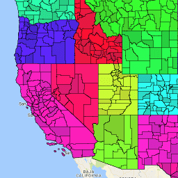
মার্কিন যুক্তরাষ্ট্রের আদমশুমারি ব্যুরো TIGER ডেটাসেটে মার্কিন যুক্তরাষ্ট্রের রাজ্যগুলির প্রাথমিক আইনি বিভাগের 2016 সালের সীমানা রয়েছে। বেশিরভাগ রাজ্যে, এই সত্তাগুলিকে "কাউন্টি" বলা হয়। লুইসিয়ানায়, এই বিভাগগুলিকে "প্যারিশ" বলা হয়।
আলাস্কায় "বরো" নামে সরকারি সত্তা রয়েছে যা কাউন্টির মতোই সরকারি ভূমিকা পালন করে, তবে কিছু ক্ষেত্রে সেই সরকারি দায়িত্বগুলি সরাসরি রাজ্য এবং কখনও কখনও একটি শহর দ্বারা পরিচালিত হয়। আলাস্কার জন্য, কাউন্টি সমতুল্য সত্তাগুলির মধ্যে রয়েছে
- সংগঠিত বরো,
- সম্মিলিত শহর এবং বরো সত্তা (যেমন জুনো),
- পৌরসভা, এবং
- আদমশুমারি এলাকা।
আলাস্কা রাজ্য এবং আদমশুমারি ব্যুরো পরিসংখ্যানগত উদ্দেশ্যে সহযোগিতামূলকভাবে আদমশুমারি এলাকাগুলিকে চিহ্নিত করেছে।
চারটি রাজ্যে (মেরিল্যান্ড, মিসৌরি, নেভাডা এবং ভার্জিনিয়া), এক বা একাধিক অন্তর্ভুক্ত স্থান রয়েছে যা যেকোনো কাউন্টি সংস্থার থেকে স্বাধীন এবং এইভাবে তাদের রাজ্যের প্রাথমিক বিভাগ গঠন করে। এই অন্তর্ভুক্ত স্থানগুলিকে স্বাধীন শহর হিসাবে পরিচিত এবং তথ্য উপস্থাপনের উদ্দেশ্যে কাউন্টি-সমতুল্য সত্তা হিসাবে বিবেচনা করা হয়।
কলম্বিয়া এবং গুয়াম জেলায় কোন প্রাথমিক বিভাগ নেই এবং তথ্য উপস্থাপনের উদ্দেশ্যে প্রতিটি এলাকাকে একটি কাউন্টি-সমতুল্য সত্তা হিসেবে বিবেচনা করা হয়। আদমশুমারি ব্যুরো তথ্য উপস্থাপনের উদ্দেশ্যে নিম্নলিখিত সত্তাগুলিকে কাউন্টির সমতুল্য হিসাবে বিবেচনা করে: পুয়ের্তো রিকোর পৌরসভা, আমেরিকার সামোয়া জেলা এবং দ্বীপপুঞ্জ, উত্তর মারিয়ানা দ্বীপপুঞ্জের কমনওয়েলথের পৌরসভা এবং মার্কিন ভার্জিন দ্বীপপুঞ্জের দ্বীপপুঞ্জ।
TIGER 2016 এর সকল পণ্যের সম্পূর্ণ প্রযুক্তিগত বিবরণের জন্য, TIGER এর প্রযুক্তিগত ডকুমেন্টেশন দেখুন।
টেবিল স্কিমা
টেবিল স্কিমা
| নাম | আদর্শ | বিবরণ |
|---|---|---|
| আল্যান্ড | দ্বিগুণ | জমির পরিমাণ |
| জল | দ্বিগুণ | জল এলাকা |
| সিবিএসএএফপি | স্ট্রিং | মেট্রোপলিটন পরিসংখ্যান এলাকা/মাইক্রোপলিটন পরিসংখ্যান এলাকা কোড |
| CLASSFP সম্পর্কে | স্ট্রিং | FIPS ক্লাস কোড |
| কাউন্টিএফপি | স্ট্রিং | কাউন্টি FIPS কোড |
| কাউন্টি | স্ট্রিং | কাউন্টি জিএনআইএস কোড |
| সিএসএএফপি | স্ট্রিং | সম্মিলিত পরিসংখ্যানগত এলাকা কোড |
| ফাংশনস্ট্যাট | স্ট্রিং | কার্যকরী অবস্থা |
| জিওআইডি | স্ট্রিং | কাউন্টি শনাক্তকারী; রাজ্য FIPS কোড এবং কাউন্টি FIPS কোডের সংমিশ্রণ |
| ইন্টিপটল্যাট | স্ট্রিং | অভ্যন্তরীণ বিন্দু অক্ষাংশ |
| INTPTLON সম্পর্কে | স্ট্রিং | অভ্যন্তরীণ বিন্দু দ্রাঘিমাংশ |
| এলএসএডি | স্ট্রিং | কাউন্টির আইনি/পরিসংখ্যানগত এলাকার বর্ণনা |
| METDIVFP সম্পর্কে | স্ট্রিং | মহানগর বিভাগ কোড |
| এমটিএফসিসি | স্ট্রিং | MAF/TIGER ফিচার ক্লাস কোড (=G4020) |
| NAME এর | স্ট্রিং | কাউন্টির নাম |
| নামলসাদ | স্ট্রিং | কাউন্টির নাম এবং অনুবাদিত আইনি/পরিসংখ্যানগত এলাকার বর্ণনা |
| স্টেটএফপি | স্ট্রিং | রাজ্য FIPS কোড |
ব্যবহারের শর্তাবলী
ব্যবহারের শর্তাবলী
মার্কিন আদমশুমারি ব্যুরো তার কিছু পাবলিক ডেটা একটি অ্যাপ্লিকেশন প্রোগ্রামিং ইন্টারফেস (API) এর মাধ্যমে মেশিন-পঠনযোগ্য ফর্ম্যাটে অফার করে। API এর মাধ্যমে উপলব্ধ সমস্ত বিষয়বস্তু, ডকুমেন্টেশন, কোড এবং সম্পর্কিত উপকরণ এই শর্তাবলীর অধীন।
উদ্ধৃতি
ডেটা সেট থেকে প্রাপ্ত যেকোনো প্রতিবেদন, প্রকাশনা, নতুন ডেটা সেট, প্রাপ্ত পণ্য বা পরিষেবা তৈরির জন্য ব্যবহারকারীদের মার্কিন আদমশুমারি ব্যুরো উল্লেখ করা উচিত।
আর্থ ইঞ্জিনের সাহায্যে ঘুরে দেখুন
কোড এডিটর (জাভাস্ক্রিপ্ট)
var dataset = ee.FeatureCollection('TIGER/2016/Counties');
var visParams = {
  palette: ['purple', 'blue', 'green', 'yellow', 'orange', 'red'],
  min: 0,
  max: 50,
  opacity: 0.8,
};
var stateDataset = ee.FeatureCollection('TIGER/2016/States');

// Turn the strings into numbers
dataset = dataset.map(function (f) {
  return f.set('STATEFP', ee.Number.parse(f.get('STATEFP')));
});

var image = ee.Image().float().paint(dataset, 'STATEFP');
var countyOutlines = ee.Image().float().paint({
  featureCollection: dataset,
  color: 'black',
  width: 1
});
var stateOutlines = ee.Image().float().paint({
  featureCollection: stateDataset,
  color: 'black',
  width: 3
});

Map.setCenter(-99.844, 37.649, 5);
Map.addLayer(image, visParams, 'TIGER/2016/Counties');
Map.addLayer(stateOutlines, {}, 'state outlines');
Map.addLayer(countyOutlines, {}, 'county outlines');
Map.addLayer(dataset, null, 'for Inspector', false);
একটি FeatureView হিসেবে ভিজ্যুয়ালাইজ করুন
FeatureView হল FeatureCollection এর একটি ত্বরিত উপস্থাপনা যা কেবলমাত্র দেখার জন্য। আরও বিস্তারিত জানার জন্য, FeatureView ডকুমেন্টেশনটি দেখুন।
কোড এডিটর (জাভাস্ক্রিপ্ট)
var fvLayer = ui.Map.FeatureViewLayer('TIGER/2016/Counties_FeatureView');

var visParams = {
  opacity: 1,
  polygonStrokeColor: 'black',
  polygonFillColor: {
    property: 'STATEFP',
    categories: [
      ['08', 'purple'],  // Colorado counties
      ['32', 'blue']     // Nevada counties
    ],
    defaultValue: 'white'
  }
};

fvLayer.setVisParams(visParams);
fvLayer.setName('US census counties');

Map.setCenter(-99.844, 37.649, 5);
Map.add(fvLayer);