Zbiór danych TIGER amerykańskiego Biura Spisu Ludności zawiera granice z 2016 r. dla podstawowych podziałów prawnych stanów USA. W większości stanów te jednostki są nazywane „hrabstwami”. W Luizjanie te jednostki podziału administracyjnego są nazywane „parish”.
Na Alasce istnieją jednostki administracyjne zwane „boroughs”, które pełnią podobną rolę jak hrabstwa, ale w niektórych obszarach obowiązki administracyjne są wykonywane bezpośrednio przez stan, a czasami przez miasto.
W przypadku Alaski odpowiednikami hrabstw są więc
zorganizowane okręgi,
połączone jednostki miejskie i okręgowe (np. Juneau),
gminy,
obszary spisowe.
Obszary spisu ludności są wyznaczane wspólnie do celów statystycznych przez stan Alaska i Biuro Spisu Ludności.
W 4 stanach (Maryland, Missouri, Nevada i Virginia) znajduje się co najmniej jedna miejscowość, która jest niezależna od organizacji hrabstwa i stanowi podstawowy podział administracyjny stanu. Te miejscowości są znane jako niezależne miasta i na potrzeby prezentacji danych są traktowane jako odpowiedniki hrabstw.
Dystrykt Kolumbii i Guam nie mają podziałów podstawowych, a każdy z tych obszarów jest traktowany jako odpowiednik hrabstwa na potrzeby prezentacji danych.
Na potrzeby prezentacji danych Biuro Spisu Ludności traktuje następujące jednostki jako odpowiedniki hrabstw: gminy w Portoryko, okręgi i wyspy w Samoa Amerykańskim, gminy we Wspólnocie Marianów Północnych oraz wyspy na Wyspach Dziewiczych Stanów Zjednoczonych.
Kod obszaru statystycznego metropolitalnego lub mikropolitalnego
CLASSFP
CIĄG ZNAKÓW
Kod klasy FIPS
COUNTYFP
CIĄG ZNAKÓW
Kod FIPS hrabstwa
COUNTYNS
CIĄG ZNAKÓW
Kod GNIS hrabstwa
CSAFP
CIĄG ZNAKÓW
Kod połączonego obszaru statystycznego
FUNCSTAT
CIĄG ZNAKÓW
Stan funkcjonalny
GEOID
CIĄG ZNAKÓW
Identyfikator hrabstwa, czyli połączenie kodu FIPS stanu i kodu FIPS hrabstwa.
INTPTLAT
CIĄG ZNAKÓW
Szerokość geograficzna wewnętrznego punktu
INTPTLON
CIĄG ZNAKÓW
Długość geograficzna punktu wewnętrznego
LSAD
CIĄG ZNAKÓW
Opis obszaru prawnego lub statystycznego dla hrabstwa
METDIVFP
CIĄG ZNAKÓW
Kod podziału metropolitalnego
MTFCC
CIĄG ZNAKÓW
Kod klasy obiektu MAF/TIGER (=G4020)
NAZWA
CIĄG ZNAKÓW
Nazwa hrabstwa
NAMELSAD
CIĄG ZNAKÓW
Nazwa i przetłumaczony opis obszaru prawnego lub statystycznego dla hrabstwa
STATEFP
CIĄG ZNAKÓW
Kod FIPS stanu
Warunki korzystania z usługi
Amerykańskie Biuro Spisu Ludności udostępnia niektóre ze swoich publicznych danych w formacie czytelnym dla maszyn za pomocą interfejsu API. Cała zawartość, dokumentacja, kod i powiązane materiały udostępniane za pomocą interfejsu API podlegają niniejszym warunkom.
Cytaty
Cytowania:
W przypadku tworzenia raportów, publikacji, nowych zbiorów danych, produktów pochodnych lub usług na podstawie zbioru danych użytkownicy powinni cytować US Census Bureau.
Zbiór danych TIGER amerykańskiego Biura Spisu Ludności zawiera granice podstawowych podziałów prawnych stanów USA z 2016 roku. W większości stanów te jednostki nazywane są „hrabstwami”. W Luizjanie te jednostki administracyjne są nazywane „parish”. Na Alasce istnieją jednostki administracyjne zwane „boroughs”, które pełnią podobną rolę jak hrabstwa, ale w …
[null,null,[],[[["\u003cp\u003eThe TIGER/2016/Counties dataset provides 2016 boundaries for US counties and county-equivalent entities from the US Census Bureau.\u003c/p\u003e\n"],["\u003cp\u003eThe dataset includes attributes like land and water area, FIPS codes, geographic identifiers, and names.\u003c/p\u003e\n"],["\u003cp\u003eUsers should cite the US Census Bureau when using this data for reports, publications, or derived products.\u003c/p\u003e\n"],["\u003cp\u003eThe dataset can be visualized and analyzed in Earth Engine using FeatureCollections and FeatureViews.\u003c/p\u003e\n"],["\u003cp\u003eThe data is subject to the US Census Bureau's terms of service and is available for research, education, and nonprofit use.\u003c/p\u003e\n"]]],["The TIGER dataset from the US Census Bureau provides 2016 boundaries for primary legal divisions within US states, typically called \"counties\" but with variations in terminology across regions. This data, available from 2016-01-01 to 2017-01-02, includes counties, parishes, boroughs, and other county-equivalent entities. The dataset contains geographical features and related attributes like area, codes, names, and status. Users can access and visualize the data via Earth Engine, utilizing code snippets and FeatureView options.\n"],null,["# TIGER: US Census Counties 2016\n\nDataset Availability\n: 2016-01-01T00:00:00Z--2017-01-02T00:00:00Z\n\nDataset Provider\n:\n\n\n [United States Census Bureau](https://www.census.gov/programs-surveys/geography/guidance/tiger-data-products-guide.html)\n\nTags\n:\n[census](/earth-engine/datasets/tags/census) [county](/earth-engine/datasets/tags/county) [infrastructure-boundaries](/earth-engine/datasets/tags/infrastructure-boundaries) [table](/earth-engine/datasets/tags/table) [tiger](/earth-engine/datasets/tags/tiger) [us](/earth-engine/datasets/tags/us) \n\n#### Description\n\nThe United States Census Bureau TIGER dataset contains the 2016 boundaries\nfor primary legal divisions of US states. In most states, these entities\nare termed \"counties\". In Louisiana, these divisions are known as\n\"parishes\".\n\nAlaska has governmental entities called \"boroughs\" which fill a similar\ngovernmental role to counties, but in some areas those governmental\nresponsibilities are handled directly by the state and sometimes by a city.\nFor Alaska, county equivalent entities thus include\n\n1. organized boroughs,\n2. combined city and borough entities (e.g. Juneau),\n3. municipalities, and\n4. census areas.\n\nThe census areas are delineated cooperatively for statistical purposes by\nthe State of Alaska and the Census Bureau.\n\nIn four states (Maryland, Missouri, Nevada, and Virginia), there are one\nor more incorporated places that are independent of any county\norganization and thus constitute primary divisions of their states. These\nincorporated places are known as independent cities and are treated as\ncounty-equivalent entities for purposes of data presentation.\n\nThe District of Columbia and Guam have no primary divisions and each area is\nconsidered a county-equivalent entity for purposes of data presentation.\nThe Census Bureau treats the following entities as equivalents of counties\nfor purposes of data presentation: municipios in Puerto Rico, districts\nand islands in America Samoa, municipalities in the Commonwealth of the\nNorthern Mariana Islands, and islands in the U.S. Virgin Islands.\n\nFor full technical details on all TIGER 2016 products, see the [TIGER\ntechnical documentation](https://www2.census.gov/geo/pdfs/maps-data/data/tiger/tgrshp2016/TGRSHP2016_TechDoc.pdf).\n\n### Table Schema\n\n**Table Schema**\n\n| Name | Type | Description |\n|----------|--------|----------------------------------------------------------------------------|\n| ALAND | DOUBLE | Land area |\n| AWATER | DOUBLE | Water area |\n| CBSAFP | STRING | Metropolitan statistical area/micropolitan statistical area code |\n| CLASSFP | STRING | FIPS class code |\n| COUNTYFP | STRING | County FIPS code |\n| COUNTYNS | STRING | County GNIS code |\n| CSAFP | STRING | Combined statistical area code |\n| FUNCSTAT | STRING | Functional Status |\n| GEOID | STRING | County identifier; a concatenation of state FIPS code and county FIPS code |\n| INTPTLAT | STRING | Internal point latitude |\n| INTPTLON | STRING | Internal point longitude |\n| LSAD | STRING | Legal/statistical area description for the county |\n| METDIVFP | STRING | Metropolitan division code |\n| MTFCC | STRING | MAF/TIGER feature class code (=G4020) |\n| NAME | STRING | County name |\n| NAMELSAD | STRING | Name and the translated legal/statistical area description for the county |\n| STATEFP | STRING | State FIPS code |\n\n### Terms of Use\n\n**Terms of Use**\n\nThe U.S. Census Bureau offers some of its public data\nin machine-readable format via an Application Programming Interface\n(API). All of the content, documentation, code and related materials\nmade available through the API are subject to [these terms and\nconditions](https://www.census.gov/data/developers/about/terms-of-service.html).\n\n### Citations\n\nCitations:\n\n- For the creation of any reports, publications, new data sets, derived\n products, or services resulting from the data set, users should\n [cite the US Census Bureau](https://www.census.gov/about/policies/citation.html).\n\n### Explore with Earth Engine\n\n| **Important:** Earth Engine is a platform for petabyte-scale scientific analysis and visualization of geospatial datasets, both for public benefit and for business and government users. Earth Engine is free to use for research, education, and nonprofit use. To get started, please [register for Earth Engine access.](https://console.cloud.google.com/earth-engine)\n\n### Code Editor (JavaScript)\n\n```javascript\n
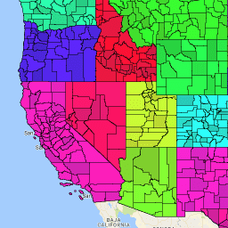
var dataset = ee.FeatureCollection('TIGER/2016/Counties');\nvar visParams = {\n palette: ['purple', 'blue', 'green', 'yellow', 'orange', 'red'],\n min: 0,\n max: 50,\n opacity: 0.8,\n};\nvar stateDataset = ee.FeatureCollection('TIGER/2016/States');\n\n// Turn the strings into numbers\ndataset = dataset.map(function (f) {\n return f.set('STATEFP', ee.Number.parse(f.get('STATEFP')));\n});\n\nvar image = ee.Image().float().paint(dataset, 'STATEFP');\nvar countyOutlines = ee.Image().float().paint({\n featureCollection: dataset,\n color: 'black',\n width: 1\n});\nvar stateOutlines = ee.Image().float().paint({\n featureCollection: stateDataset,\n color: 'black',\n width: 3\n});\n\nMap.setCenter(-99.844, 37.649, 5);\nMap.addLayer(image, visParams, 'TIGER/2016/Counties');\nMap.addLayer(stateOutlines, {}, 'state outlines');\nMap.addLayer(countyOutlines, {}, 'county outlines');\nMap.addLayer(dataset, null, 'for Inspector', false);\n```\n[Open in Code Editor](https://code.earthengine.google.com/?scriptPath=Examples:Datasets/TIGER/TIGER_2016_Counties)\n\n### Visualize as a FeatureView\n\n\nA `FeatureView` is a view-only, accelerated representation of a\n`FeatureCollection`. For more details, visit the\n[`FeatureView` documentation.](/earth-engine/guides/featureview_overview)\n| **Important:** Earth Engine is a platform for petabyte-scale scientific analysis and visualization of geospatial datasets, both for public benefit and for business and government users. Earth Engine is free to use for research, education, and nonprofit use. To get started, please [register for Earth Engine access.](https://console.cloud.google.com/earth-engine)\n\n### Code Editor (JavaScript)\n\n```javascript\nvar fvLayer = ui.Map.FeatureViewLayer('TIGER/2016/Counties_FeatureView');\n\nvar visParams = {\n opacity: 1,\n polygonStrokeColor: 'black',\n polygonFillColor: {\n property: 'STATEFP',\n categories: [\n ['08', 'purple'], // Colorado counties\n ['32', 'blue'] // Nevada counties\n ],\n defaultValue: 'white'\n }\n};\n\nfvLayer.setVisParams(visParams);\nfvLayer.setName('US census counties');\n\nMap.setCenter(-99.844, 37.649, 5);\nMap.add(fvLayer);\n```\n[Open in Code Editor](https://code.earthengine.google.com/?scriptPath=Examples:Datasets/TIGER/TIGER_2016_Counties_FeatureView) \n[TIGER: US Census Counties 2016](/earth-engine/datasets/catalog/TIGER_2016_Counties) \nThe United States Census Bureau TIGER dataset contains the 2016 boundaries for primary legal divisions of US states. In most states, these entities are termed \"counties\". In Louisiana, these divisions are known as \"parishes\". Alaska has governmental entities called \"boroughs\" which fill a similar governmental role to counties, but in ... \nTIGER/2016/Counties, census,county,infrastructure-boundaries,table,tiger,us \n2016-01-01T00:00:00Z/2017-01-02T00:00:00Z \n-14.69 -180 71.567 -64.435 \nGoogle Earth Engine \nhttps://developers.google.com/earth-engine/datasets\n\n- [](https://doi.org/https://www.census.gov/programs-surveys/geography/guidance/tiger-data-products-guide.html)\n- [](https://doi.org/https://developers.google.com/earth-engine/datasets/catalog/TIGER_2016_Counties)"]]