Набор данных TIGER Бюро переписи населения США содержит границы основных административно-территориальных единиц штатов США по состоянию на 2016 год. В большинстве штатов эти единицы называются «округами». В Луизиане такие единицы называются «приходами».
На Аляске существуют государственные образования, называемые «боро», которые выполняют функции, аналогичные функциям округов, но в некоторых районах эти функции управления выполняются непосредственно штатом, а иногда и городом. Таким образом, для Аляски к соответствующим образованиям относятся:
организованные районы,
объединенные городские и районные образования (например, Джуно),
муниципалитеты и
переписных участков.
Территории переписи населения определяются совместно штатом Аляска и Бюро переписи населения в статистических целях.
В четырёх штатах (Мэриленд, Миссури, Невада и Вирджиния) есть одна или несколько инкорпорированных территорий, не зависящих от какой-либо окружной организации и, таким образом, составляющих основные административные единицы своих штатов. Эти инкорпорированные территории называются независимыми городами и рассматриваются как эквивалентные округам образования для целей представления данных.
В округе Колумбия и на Гуаме нет первичных единиц административного деления, и каждая территория считается эквивалентом округа для целей представления данных. Бюро переписи населения рассматривает следующие субъекты как эквиваленты округов для целей представления данных: муниципалитеты в Пуэрто-Рико, районы и острова в Американском Самоа, муниципалитеты в Содружестве Северных Марианских Островов и острова в составе Американских Виргинских Островов.
Код столичного статистического района/микрополитического статистического района
CLASSFP
НИТЬ
Код класса FIPS
COUNTYFP
НИТЬ
Код округа FIPS
ОКРУГА
НИТЬ
Код GNIS округа
CSAFP
НИТЬ
Комбинированный статистический код зоны
ФУНКСТАТ
НИТЬ
Функциональное состояние
ГЕОИД
НИТЬ
Идентификатор округа; объединение кода FIPS штата и кода FIPS округа
ИНТПЛАТ
НИТЬ
Широта внутренней точки
ИНПТЛОН
НИТЬ
Долгота внутренней точки
ЛСАД
НИТЬ
Юридическое/статистическое описание округа
METDIVFP
НИТЬ
Код столичного округа
МТФКК
НИТЬ
Код класса объектов MAF/TIGER (=G4020)
ИМЯ
НИТЬ
Название округа
НАМЕЛЬСАД
НИТЬ
Название и переведенное юридическое/статистическое описание округа
STATEFP
НИТЬ
Государственный код FIPS
Условия эксплуатации
Бюро переписи населения США предоставляет часть своих общедоступных данных в машиночитаемом формате через интерфейс прикладного программирования (API). Весь контент, документация, код и сопутствующие материалы, доступные через API, регулируются настоящими условиями .
Цитаты
Цитаты:
Для создания любых отчетов, публикаций, новых наборов данных, производных продуктов или услуг на основе набора данных пользователи должны ссылаться на Бюро переписи населения США .
Набор данных TIGER Бюро переписи населения США содержит границы основных административно-территориальных единиц штатов США за 2016 год. В большинстве штатов эти единицы называются «округа». В Луизиане эти единицы называются «приходами». На Аляске существуют административные единицы, называемые «боро», которые выполняют аналогичную функцию в управлении округами, но…
[null,null,[],[[["\u003cp\u003eThe TIGER/2016/Counties dataset provides 2016 boundaries for US counties and county-equivalent entities from the US Census Bureau.\u003c/p\u003e\n"],["\u003cp\u003eThe dataset includes attributes like land and water area, FIPS codes, geographic identifiers, and names.\u003c/p\u003e\n"],["\u003cp\u003eUsers should cite the US Census Bureau when using this data for reports, publications, or derived products.\u003c/p\u003e\n"],["\u003cp\u003eThe dataset can be visualized and analyzed in Earth Engine using FeatureCollections and FeatureViews.\u003c/p\u003e\n"],["\u003cp\u003eThe data is subject to the US Census Bureau's terms of service and is available for research, education, and nonprofit use.\u003c/p\u003e\n"]]],["The TIGER dataset from the US Census Bureau provides 2016 boundaries for primary legal divisions within US states, typically called \"counties\" but with variations in terminology across regions. This data, available from 2016-01-01 to 2017-01-02, includes counties, parishes, boroughs, and other county-equivalent entities. The dataset contains geographical features and related attributes like area, codes, names, and status. Users can access and visualize the data via Earth Engine, utilizing code snippets and FeatureView options.\n"],null,["# TIGER: US Census Counties 2016\n\nDataset Availability\n: 2016-01-01T00:00:00Z--2017-01-02T00:00:00Z\n\nDataset Provider\n:\n\n\n [United States Census Bureau](https://www.census.gov/programs-surveys/geography/guidance/tiger-data-products-guide.html)\n\nTags\n:\n[census](/earth-engine/datasets/tags/census) [county](/earth-engine/datasets/tags/county) [infrastructure-boundaries](/earth-engine/datasets/tags/infrastructure-boundaries) [table](/earth-engine/datasets/tags/table) [tiger](/earth-engine/datasets/tags/tiger) [us](/earth-engine/datasets/tags/us) \n\n#### Description\n\nThe United States Census Bureau TIGER dataset contains the 2016 boundaries\nfor primary legal divisions of US states. In most states, these entities\nare termed \"counties\". In Louisiana, these divisions are known as\n\"parishes\".\n\nAlaska has governmental entities called \"boroughs\" which fill a similar\ngovernmental role to counties, but in some areas those governmental\nresponsibilities are handled directly by the state and sometimes by a city.\nFor Alaska, county equivalent entities thus include\n\n1. organized boroughs,\n2. combined city and borough entities (e.g. Juneau),\n3. municipalities, and\n4. census areas.\n\nThe census areas are delineated cooperatively for statistical purposes by\nthe State of Alaska and the Census Bureau.\n\nIn four states (Maryland, Missouri, Nevada, and Virginia), there are one\nor more incorporated places that are independent of any county\norganization and thus constitute primary divisions of their states. These\nincorporated places are known as independent cities and are treated as\ncounty-equivalent entities for purposes of data presentation.\n\nThe District of Columbia and Guam have no primary divisions and each area is\nconsidered a county-equivalent entity for purposes of data presentation.\nThe Census Bureau treats the following entities as equivalents of counties\nfor purposes of data presentation: municipios in Puerto Rico, districts\nand islands in America Samoa, municipalities in the Commonwealth of the\nNorthern Mariana Islands, and islands in the U.S. Virgin Islands.\n\nFor full technical details on all TIGER 2016 products, see the [TIGER\ntechnical documentation](https://www2.census.gov/geo/pdfs/maps-data/data/tiger/tgrshp2016/TGRSHP2016_TechDoc.pdf).\n\n### Table Schema\n\n**Table Schema**\n\n| Name | Type | Description |\n|----------|--------|----------------------------------------------------------------------------|\n| ALAND | DOUBLE | Land area |\n| AWATER | DOUBLE | Water area |\n| CBSAFP | STRING | Metropolitan statistical area/micropolitan statistical area code |\n| CLASSFP | STRING | FIPS class code |\n| COUNTYFP | STRING | County FIPS code |\n| COUNTYNS | STRING | County GNIS code |\n| CSAFP | STRING | Combined statistical area code |\n| FUNCSTAT | STRING | Functional Status |\n| GEOID | STRING | County identifier; a concatenation of state FIPS code and county FIPS code |\n| INTPTLAT | STRING | Internal point latitude |\n| INTPTLON | STRING | Internal point longitude |\n| LSAD | STRING | Legal/statistical area description for the county |\n| METDIVFP | STRING | Metropolitan division code |\n| MTFCC | STRING | MAF/TIGER feature class code (=G4020) |\n| NAME | STRING | County name |\n| NAMELSAD | STRING | Name and the translated legal/statistical area description for the county |\n| STATEFP | STRING | State FIPS code |\n\n### Terms of Use\n\n**Terms of Use**\n\nThe U.S. Census Bureau offers some of its public data\nin machine-readable format via an Application Programming Interface\n(API). All of the content, documentation, code and related materials\nmade available through the API are subject to [these terms and\nconditions](https://www.census.gov/data/developers/about/terms-of-service.html).\n\n### Citations\n\nCitations:\n\n- For the creation of any reports, publications, new data sets, derived\n products, or services resulting from the data set, users should\n [cite the US Census Bureau](https://www.census.gov/about/policies/citation.html).\n\n### Explore with Earth Engine\n\n| **Important:** Earth Engine is a platform for petabyte-scale scientific analysis and visualization of geospatial datasets, both for public benefit and for business and government users. Earth Engine is free to use for research, education, and nonprofit use. To get started, please [register for Earth Engine access.](https://console.cloud.google.com/earth-engine)\n\n### Code Editor (JavaScript)\n\n```javascript\n
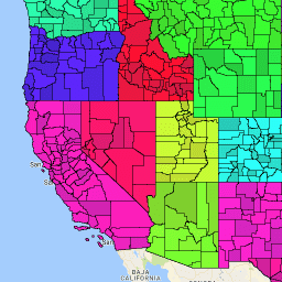
var dataset = ee.FeatureCollection('TIGER/2016/Counties');\nvar visParams = {\n palette: ['purple', 'blue', 'green', 'yellow', 'orange', 'red'],\n min: 0,\n max: 50,\n opacity: 0.8,\n};\nvar stateDataset = ee.FeatureCollection('TIGER/2016/States');\n\n// Turn the strings into numbers\ndataset = dataset.map(function (f) {\n return f.set('STATEFP', ee.Number.parse(f.get('STATEFP')));\n});\n\nvar image = ee.Image().float().paint(dataset, 'STATEFP');\nvar countyOutlines = ee.Image().float().paint({\n featureCollection: dataset,\n color: 'black',\n width: 1\n});\nvar stateOutlines = ee.Image().float().paint({\n featureCollection: stateDataset,\n color: 'black',\n width: 3\n});\n\nMap.setCenter(-99.844, 37.649, 5);\nMap.addLayer(image, visParams, 'TIGER/2016/Counties');\nMap.addLayer(stateOutlines, {}, 'state outlines');\nMap.addLayer(countyOutlines, {}, 'county outlines');\nMap.addLayer(dataset, null, 'for Inspector', false);\n```\n[Open in Code Editor](https://code.earthengine.google.com/?scriptPath=Examples:Datasets/TIGER/TIGER_2016_Counties)\n\n### Visualize as a FeatureView\n\n\nA `FeatureView` is a view-only, accelerated representation of a\n`FeatureCollection`. For more details, visit the\n[`FeatureView` documentation.](/earth-engine/guides/featureview_overview)\n| **Important:** Earth Engine is a platform for petabyte-scale scientific analysis and visualization of geospatial datasets, both for public benefit and for business and government users. Earth Engine is free to use for research, education, and nonprofit use. To get started, please [register for Earth Engine access.](https://console.cloud.google.com/earth-engine)\n\n### Code Editor (JavaScript)\n\n```javascript\nvar fvLayer = ui.Map.FeatureViewLayer('TIGER/2016/Counties_FeatureView');\n\nvar visParams = {\n opacity: 1,\n polygonStrokeColor: 'black',\n polygonFillColor: {\n property: 'STATEFP',\n categories: [\n ['08', 'purple'], // Colorado counties\n ['32', 'blue'] // Nevada counties\n ],\n defaultValue: 'white'\n }\n};\n\nfvLayer.setVisParams(visParams);\nfvLayer.setName('US census counties');\n\nMap.setCenter(-99.844, 37.649, 5);\nMap.add(fvLayer);\n```\n[Open in Code Editor](https://code.earthengine.google.com/?scriptPath=Examples:Datasets/TIGER/TIGER_2016_Counties_FeatureView) \n[TIGER: US Census Counties 2016](/earth-engine/datasets/catalog/TIGER_2016_Counties) \nThe United States Census Bureau TIGER dataset contains the 2016 boundaries for primary legal divisions of US states. In most states, these entities are termed \"counties\". In Louisiana, these divisions are known as \"parishes\". Alaska has governmental entities called \"boroughs\" which fill a similar governmental role to counties, but in ... \nTIGER/2016/Counties, census,county,infrastructure-boundaries,table,tiger,us \n2016-01-01T00:00:00Z/2017-01-02T00:00:00Z \n-14.69 -180 71.567 -64.435 \nGoogle Earth Engine \nhttps://developers.google.com/earth-engine/datasets\n\n- [](https://doi.org/https://www.census.gov/programs-surveys/geography/guidance/tiger-data-products-guide.html)\n- [](https://doi.org/https://developers.google.com/earth-engine/datasets/catalog/TIGER_2016_Counties)"]]