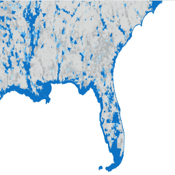
Amerykańskie Biuro Spisu Ludności regularnie udostępnia geobazę danych o nazwie TIGER. Ten zbiór danych zawiera grupy bloków ze spisu ludności z 2020 roku, czyli klastry bloków w tym samym okręgu spisowym, które mają taką samą pierwszą cyfrę czterocyfrowego numeru bloku spisowego. Jest ich nieco ponad 240 tys. i obejmują Stany Zjednoczone, Dystrykt Kolumbii, Portoryko i wyspy.
Unikalny identyfikator poziomu podsumowania, charakterystyka, iteracja, USA, stan, hrabstwo, kod okręgu, kod grupy bloków
INTPTLAT
LICZBA ZMIENNOPRZECINKOWA O PODWÓJNEJ PRECYZJI
Wewnętrzna szerokość geograficzna punktu
INTPTLON
LICZBA ZMIENNOPRZECINKOWA O PODWÓJNEJ PRECYZJI
Długość geograficzna wewnętrznego punktu
MTFCC
CIĄG ZNAKÓW
Kod klasyfikacji funkcji MAF/TIGER
NAMELSAD
CIĄG ZNAKÓW
Imię i nazwisko
STATEFP
CIĄG ZNAKÓW
Kod FIPS stanu
TRACTCE
CIĄG ZNAKÓW
Kod okręgu spisowego
Warunki korzystania z usługi
Amerykańskie Biuro Spisu Ludności udostępnia niektóre ze swoich publicznych danych w formacie czytelnym dla maszyn za pomocą interfejsu API. Wszystkie treści, dokumentacja, kod i materiały powiązane udostępniane Ci za pomocą interfejsu API podlegają niniejszym warunkom.
Cytaty
Cytowania:
W przypadku tworzenia raportów, publikacji, nowych zbiorów danych, produktów pochodnych lub usług na podstawie zbioru danych użytkownicy powinni cytować US Census Bureau.
Amerykańskie Biuro Spisu Ludności regularnie udostępnia bazę danych geograficznych o nazwie TIGER. Ten zbiór danych zawiera grupy bloków spisu ludności z 2020 roku, czyli klastry bloków w tym samym okręgu spisowym, które mają tę samą pierwszą cyfrę czterocyfrowego numeru bloku spisu ludności. Jest nieco ponad 240 tys. wielokątów obejmujących…
[null,null,[],[[["\u003cp\u003eThe TIGER/2020/BG dataset provides 2020 US Census block group boundaries, encompassing over 240,000 polygons across the United States, District of Columbia, Puerto Rico, and Island areas.\u003c/p\u003e\n"],["\u003cp\u003eBlock groups are clusters of blocks within the same census tract sharing the first digit of their four-digit census block number.\u003c/p\u003e\n"],["\u003cp\u003eThe dataset includes attributes such as land and water area, geographic identifiers, and demographic characteristics.\u003c/p\u003e\n"],["\u003cp\u003eUsers should cite the US Census Bureau when using this data for reports, publications, or derived products.\u003c/p\u003e\n"],["\u003cp\u003eThe dataset is available as a FeatureCollection and FeatureView for analysis and visualization within Google Earth Engine.\u003c/p\u003e\n"]]],[],null,["# TIGER: US Census Block Groups (BG) 2020\n\nDataset Availability\n: 2020-01-01T00:00:00Z--2020-01-02T00:00:00Z\n\nDataset Provider\n:\n\n\n [United States Census Bureau](https://www.census.gov/programs-surveys/geography/guidance/tiger-data-products-guide.html)\n\nTags\n:\n[census](/earth-engine/datasets/tags/census) [city](/earth-engine/datasets/tags/city) [infrastructure-boundaries](/earth-engine/datasets/tags/infrastructure-boundaries) [neighborhood](/earth-engine/datasets/tags/neighborhood) [table](/earth-engine/datasets/tags/table) [tiger](/earth-engine/datasets/tags/tiger) [urban](/earth-engine/datasets/tags/urban) [us](/earth-engine/datasets/tags/us) \n\n#### Description\n\nThe United States Census Bureau regularly releases\na geodatabase named TIGER. This dataset contains the 2020 census\n[block groups](https://www.census.gov/programs-surveys/geography/about/glossary.html#par_textimage_4),\nwhich is a cluster of blocks within the same census tract that have the same\nfirst digit of their four-digit census block number. There are just over\n240,000 polygon features covering the United States, the District\nof Columbia, Puerto Rico, and the\nIsland areas.\n\nFor full technical details on all TIGER 2020 products, see the\n[TIGER technical documentation](https://www2.census.gov/geo/pdfs/maps-data/data/tiger/tgrshp2020/TGRSHP2020_TechDoc.pdf).\n\n### Table Schema\n\n**Table Schema**\n\n| Name | Type | Description |\n|----------|--------|----------------------------------------------------------------------------------------------------------|\n| ALAND | DOUBLE | Land Area (square meters) |\n| AWATER | DOUBLE | Water Area (square meters) |\n| BLKGRPCE | STRING | Block Group Code |\n| COUNTYFP | STRING | County FIPS Code |\n| FUNCSTAT | STRING | Functional Status (S = Statistical) |\n| GEOID | STRING | Unique Identifier of Summary Level, Characteristic Iteration, US, State, County, Tract, Block Group Code |\n| INTPTLAT | DOUBLE | Internal Point Latitude |\n| INTPTLON | DOUBLE | Internal Point Longitude |\n| MTFCC | STRING | MAF/TIGER Feature Classification Code |\n| NAMELSAD | STRING | Full Name |\n| STATEFP | STRING | State FIPS Code |\n| TRACTCE | STRING | Census Tract Code |\n\n### Terms of Use\n\n**Terms of Use**\n\nThe U.S. Census Bureau offers some of its public data\nin machine-readable format via an Application Programming Interface\n(API). All of the content, documentation, code and related materials\nmade available to you through the API are subject to [these terms and\nconditions](https://www.census.gov/data/developers/about/terms-of-service.html).\n\n### Citations\n\nCitations:\n\n- For the creation of any reports, publications, new data sets, derived\n products, or services resulting from the data set, users should\n [cite the US Census Bureau](https://www.census.gov/about/policies/citation.html).\n\n### Explore with Earth Engine\n\n| **Important:** Earth Engine is a platform for petabyte-scale scientific analysis and visualization of geospatial datasets, both for public benefit and for business and government users. Earth Engine is free to use for research, education, and nonprofit use. To get started, please [register for Earth Engine access.](https://console.cloud.google.com/earth-engine)\n\n### Code Editor (JavaScript)\n\n```javascript\nvar dataset = ee.FeatureCollection('TIGER/2020/BG');\n\nvar visParams = {\n min: 0.0,\n max: 1e7,\n palette: ['d8d9d9', 'aaaaaa', 'b6dfe9', '2ea3f2', '0c71c3']\n};\n\n// plotting the water area per polygon\ndataset = dataset.map(function (f) {\n return f.set('AWATER', ee.Number.parse(f.get('AWATER')));\n});\n\nvar image = ee.Image().float().paint(dataset, 'AWATER');\n\nMap.setCenter(-81.99172, 29.74101, 9);\nMap.addLayer(ee.Image(1), {min:0, max:1}, 'background');\nMap.addLayer(image, visParams, 'TIGER/2020/BG');\nMap.addLayer(dataset, null, 'for Inspector', false);\n```\n[Open in Code Editor](https://code.earthengine.google.com/?scriptPath=Examples:Datasets/TIGER/TIGER_2020_BG)\n\n### Visualize as a FeatureView\n\n\nA `FeatureView` is a view-only, accelerated representation of a\n`FeatureCollection`. For more details, visit the\n[`FeatureView` documentation.](/earth-engine/guides/featureview_overview)\n| **Important:** Earth Engine is a platform for petabyte-scale scientific analysis and visualization of geospatial datasets, both for public benefit and for business and government users. Earth Engine is free to use for research, education, and nonprofit use. To get started, please [register for Earth Engine access.](https://console.cloud.google.com/earth-engine)\n\n### Code Editor (JavaScript)\n\n```javascript\nvar fvLayer = ui.Map.FeatureViewLayer('TIGER/2020/BG_FeatureView');\n\nvar visParams = {\n opacity: 1,\n color: {\n property: 'AWATER',\n mode: 'linear',\n palette: ['d8d9d9', 'aaaaaa', 'b6dfe9', '2ea3f2', '0c71c3'],\n min: 0,\n max: 1e7\n }\n};\n\nfvLayer.setVisParams(visParams);\nfvLayer.setName('Water area by US census block group');\n\nMap.setCenter(-74.0637, 40.6852, 13);\nMap.add(fvLayer);\n```\n[Open in Code Editor](https://code.earthengine.google.com/?scriptPath=Examples:Datasets/TIGER/TIGER_2020_BG_FeatureView) \n[TIGER: US Census Block Groups (BG) 2020](/earth-engine/datasets/catalog/TIGER_2020_BG) \nThe United States Census Bureau regularly releases a geodatabase named TIGER. This dataset contains the 2020 census block groups, which is a cluster of blocks within the same census tract that have the same first digit of their four-digit census block number. There are just over 240,000 polygon features covering ... \nTIGER/2020/BG, census,city,infrastructure-boundaries,neighborhood,table,tiger,urban,us \n2020-01-01T00:00:00Z/2020-01-02T00:00:00Z \n-14.69 -180 71.567 -64.435 \nGoogle Earth Engine \nhttps://developers.google.com/earth-engine/datasets\n\n- [](https://doi.org/https://www.census.gov/programs-surveys/geography/guidance/tiger-data-products-guide.html)\n- [](https://doi.org/https://developers.google.com/earth-engine/datasets/catalog/TIGER_2020_BG)"]]