- Dostępność zbioru danych
- 1981-01-01T00:00:00Z–2025-11-26T00:00:00Z
- Dostawca zbioru danych
- UCSB/CHG
- Cykl
- 1 Custom_time_unit
- Tagi
Opis
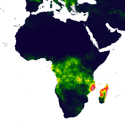
Climate Hazards Center InfraRed Precipitation with Station data (CHIRPS) to zbiór danych o opadach deszczu obejmujący ponad 30 lat i niemal cały świat. CHIRPS wykorzystuje zdjęcia satelitarne o rozdzielczości 0,05° oraz dane ze stacji naziemnych, aby tworzyć siatki czasowe opadów deszczu do analizy trendów i sezonowego monitorowania suszy.
Pasma
Rozmiar piksela
5566 m
Pasma
| Nazwa | Jednostki | Min. | Maks. | Rozmiar piksela | Opis |
|---|---|---|---|---|---|
precipitation |
mm/pentad | 0* | 1072,43* | metry | Opady |
Właściwości obrazu
Właściwości obrazu
| Nazwa | Typ | Opis |
|---|---|---|
| miesiąc | LICZBA ZMIENNOPRZECINKOWA O PODWÓJNEJ PRECYZJI | Miesiąc |
| pentada, | LICZBA ZMIENNOPRZECINKOWA O PODWÓJNEJ PRECYZJI | Pentad |
| rok | LICZBA ZMIENNOPRZECINKOWA O PODWÓJNEJ PRECYZJI | Rok |
Warunki korzystania z usługi
Warunki usługi
Te zbiory danych należą do domeny publicznej. W zakresie dopuszczalnym przez prawo Pete Peterson zrzekł się wszelkich praw autorskich i pokrewnych do danych Climate Hazards Center Infrared Precipitation with Stations (CHIRPS).
Cytaty
Funk, Chris, Pete Peterson, Martin Landsfeld, Diego Pedreros, James Verdin, Shraddhanand Shukla, Gregory Husak, James Rowland, Laura Harrison, Andrew Hoell & Joel Michaelsen. „The climate hazards infrared precipitation with stations-a new environmental record for monitoring extremes”. Scientific Data 2, 150066. doi:10.1038/sdata.2015.66 2015.
Odkrywaj za pomocą Earth Engine
Edytor kodu (JavaScript)
var dataset = ee.ImageCollection('UCSB-CHG/CHIRPS/PENTAD')
                  .filter(ee.Filter.date('2018-05-01', '2018-05-05'));
var precipitation = dataset.select('precipitation');
var precipitationVis = {
  min: 0,
  max: 112,
  palette: ['001137', '0aab1e', 'e7eb05', 'ff4a2d', 'e90000'],
};
Map.setCenter(17.93, 7.71, 2);
Map.addLayer(precipitation, precipitationVis, 'Precipitation');