- Dostępność zbioru danych
- 2000-06-06T00:00:00Z–2022-04-02T00:00:00Z
- Dostawca zbioru danych
- UK Environment Agency
- Tagi
Opis
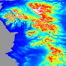
LIDAR Composite DTM/DSM to rastrowy model terenu obejmujący ok. 99% Anglii w rozdzielczości przestrzennej 1 m, wyprodukowany przez brytyjską Agencję Środowiska w 2022 r. Model zawiera 3 pasma danych o terenie: cyfrowy model terenu (DTM), cyfrowy model powierzchni (DSM) pierwszego odbicia i cyfrowy model powierzchni ostatniego odbicia.
DTM jest tworzony na podstawie ostatniego lub jedynego impulsu lasera zwróconego do czujnika. Obiekty na powierzchni są usuwane z DSM za pomocą specjalnych algorytmów i ręcznej edycji danych, aby uzyskać model terenu obejmujący tylko powierzchnię. DTM jest tworzony na podstawie połączonych i ponownie próbkowanych danych z archiwum EA Time Stamped i badań w ramach National LIDAR Program, co zapewnia najlepsze możliwe pokrycie. W przypadku powtarzanych badań wykorzystywane są najnowsze dane o najlepszej rozdzielczości. W przypadku danych, które zostały poddane ponownemu próbkowaniu, przed scaleniem zastosowano interpolację dwuliniową. Kompozyt LIDAR z 2022 r. zawiera dane z pomiarów przeprowadzonych między 6 czerwca 2000 r. a 2 kwietnia 2022 r.
Pierwszy DSM jest tworzony na podstawie pierwszego lub jedynego impulsu lasera, który powrócił do czujnika. Zawiera wysokości obiektów, takich jak pojazdy, budynki i roślinność, a także powierzchnię terenu, w przypadku której pierwszym lub jedynym powrotem była ziemia. Pierwszy DSM zwrotny pochodzi z danych zebranych w ramach programu National LIDAR w okresie od 11 listopada 2016 r. do 5 maja 2022 r. W ramach tego programu podzielono Anglię na około 300 bloków, w których od 2016 roku prowadzono badania w okresie zimowym. Te ankiety są łączone w celu utworzenia pierwszego kompozytu LIDAR, który wykorzystuje technikę rozmywania na obszarach nakładających się, aby usunąć niewielkie różnice w wysokości między ankietami. Zapoznaj się z katalogami indeksów metadanych dostawcy danych, które pokazują, w którym miejscu użyto którego badania do utworzenia kompozytu LIDAR. Pierwszy zwrócony DSM nie będzie pasować do ostatniego zwróconego DSM pod względem pokrycia ani zakresu, ponieważ ostatni zwrócony DSM jest tworzony na podstawie danych z National LIDAR Program i badań szeregów czasowych.
Ostatni zwrócony DSM jest tworzony na podstawie ostatniego lub jedynego impulsu lasera zwróconego do czujnika i zawiera wysokości obiektów, takich jak pojazdy, budynki i roślinność, a także powierzchnię terenu. Ostatni DTM jest wyprowadzany z połączenia archiwum EA Time Stamped i badań National LIDAR Program, które zostały połączone i ponownie próbkowane, aby zapewnić jak najlepsze pokrycie. W przypadku powtarzanych badań wykorzystywane są najnowsze dane o najlepszej rozdzielczości. W przypadku ponownego próbkowania danych przed ich scaleniem stosowano interpolację dwuliniową. Kompozyt LIDAR z 2022 r. zawiera dane z pomiarów przeprowadzonych między 6 czerwca 2000 r. a 2 kwietnia 2022 r. Zapoznaj się z katalogami indeksów metadanych dostawcy danych, które pokazują, w którym miejscu użyto którego badania do utworzenia kompozytu LIDAR.
Dane są dopasowywane do siatki krajowej OS i podawane w metrach w odniesieniu do Ordnance Survey Newlyn z użyciem metody przekształcenia OSTN'15. Wszystkie poszczególne pomiary LIDAR wykorzystane do utworzenia kompozytów miały dokładność pionową +/-15 cm błędu średniokwadratowego.
Pasma
Rozmiar piksela
1 metr
Pasma
| Nazwa | Jednostki | Rozmiar piksela | Opis |
|---|---|---|---|
dtm |
m | metry | Cyfrowy model terenu |
dsm_first |
m | metry | Pierwszy powrót modelu cyfrowej powierzchni |
dsm_last |
m | metry | Last Return Digital Surface Model |
Warunki korzystania z usługi
Warunki korzystania z usługi
Możesz kopiować, publikować, rozpowszechniać i przekazywać Informacje, dostosowywać je oraz wykorzystywać komercyjnie i niekomercyjnie, np. łącząc je z innymi Informacjami lub włączając je do własnego produktu lub aplikacji.
Musisz podać źródło informacji w swoim produkcie lub aplikacji, umieszczając oświadczenie o autorstwie określone przez dostawców informacji lub dodając do niego link. W miarę możliwości podaj też link do licencji. Oświadczenie o atrybucji: prawa autorskie i/lub prawa do bazy danych Agencji Środowiska 2022 r. Wszelkie prawa zastrzeżone.
Odkrywanie za pomocą Earth Engine
Edytor kodu (JavaScript)
var img = ee.Image('UK/EA/ENGLAND_1M_TERRAIN/2022').select('dtm');
var visParam = {
  palette: ['0000ff', '00ffff', 'ffff00', 'ff0000', 'ffffff'],
  max: 630,
  min: -5,
};

var lon = -2.5;
var lat = 54;

Map.addLayer(img, visParam, 'dtm');
Map.setCenter(lon, lat, 5);