- Dostępność zbioru danych
- 2001-01-01T00:00:00Z–2002-01-01T00:00:00Z
- Dostawca zbioru danych
- UMD/GLAD
- Tagi
Opis
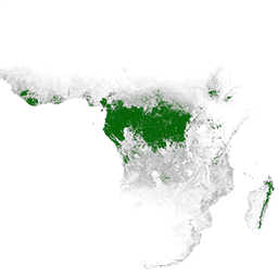
Pierwotne wilgotne lasy tropikalne zapewniają wiele globalnych usług ekosystemowych, ale są stale zagrożone wycinką z powodów ekonomicznych. Aby ułatwić krajowe planowanie przestrzenne i zrównoważyć cele rozwoju gospodarczego oraz utrzymania usług ekosystemowych, zespół GLAD z UMD stworzył mapę pierwotnych wilgotnych lasów tropikalnych. Zasięg pierwotnych lasów został wyznaczony na rok 2001 w rozdzielczości przestrzennej 30 metrów na podstawie zdjęć satelitarnych Landsat, które zostały uzyskane na całym świecie, są bezpłatne i przetwarzane w spójny sposób.
Pasma
Rozmiar piksela
30 metrów
Pasma
| Nazwa | Rozmiar piksela | Opis |
|---|---|---|
Primary_HT_forests |
metry | Pierwotne wilgotne lasy tropikalne |
Tabela klas Primary_HT_forests
| Wartość | Kolor | Opis |
|---|---|---|
| 1 | #008000 | Pierwotne wilgotne lasy tropikalne |
Warunki korzystania z usługi
Warunki korzystania z usługi
Dane mogą być używane przez każdego, w dowolnym miejscu i czasie, bez pozwolenia, licencji lub opłaty licencyjnej. Wymagamy podania atrybucji w postaci zalecanego cytatu.
Cytaty
Turubanova S., Potapov P., Tyukavina, A., and Hansen M. (2018) Trwająca utrata pierwotnych lasów w Brazylii, Demokratycznej Republice Konga i Indonezji. Environmental Research Letters. https://doi.org/10.1088/1748-9326/aacd1c
Odkrywanie za pomocą Earth Engine
Edytor kodu (JavaScript)
var dataset = ee.ImageCollection(
    'UMD/GLAD/PRIMARY_HUMID_TROPICAL_FORESTS/v1').mosaic().selfMask();

var visualization = {
  bands: ['Primary_HT_forests'],
  min: 1.0,
  max: 1.0,
  palette: ['008000']
};

Map.setCenter(0.0, 0.0, 2);

Map.addLayer(dataset, visualization, 'Primary HT forests');