- Доступность набора данных
- 1986-01-01T00:00:00Z–2025-01-01T00:00:00Z
- Производитель наборов данных
- Университет Монтаны / Климатическое управление Монтаны
- Теги
Описание
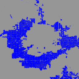
IrrMapper — это ежегодная классификация состояния орошения в 11 западных штатах США, составленная на основе данных Landsat (т.е. 30 м) с использованием алгоритма Random Forest и охватывающая период с 1986 года по настоящее время.
Хотя в статье об IrrMapper описывается классификация по четырем классам (т.е. орошаемые, неорошаемые, необрабатываемые, заболоченные территории), набор данных преобразуется в бинарную классификацию орошаемых и неорошаемых территорий.
Термин «орошаемые» относится к случаям орошения в течение года. Модель случайного леса IrrMapper была обучена с использованием обширной геопространственной базы данных о земельном покрове для каждого из четырех классов орошаемых и неорошаемых земель, включая более 50 000 подтвержденных человеком орошаемых полей, 38 000 полей, обрабатываемых в неорошаемых условиях, и более 500 000 квадратных километров необработанных земель.
В версии 1.2 исходные обучающие данные были значительно расширены, для каждого штата была построена модель случайного леса, а также проведена более тщательная проверка и анализ неопределенности. См. приложение к нашей статье о влиянии орошения на речной сток.
Группы
Группы
Размер пикселя: 30 метров (все диапазоны)
| Имя | Размер пикселя | Описание |
|---|---|---|
classification | 30 метров | Пиксели, подвергающиеся орошению, имеют значение 1, остальные пиксели маскируются. |
Условия эксплуатации
Условия эксплуатации
Цитаты
Кетчум, Д.; Дженссо, К.; Манета, М.П.; Мелтон, Ф.; Джонс, М.О.; Хантингтон, Дж. IrrMapper: подход машинного обучения для высокоточного картирования орошаемого земледелия на западе США, Remote Sens. 2020, 12, 2328. doi:10.3390/rs12142328
Кетчум, Д., Хойлман, З.Х., Хантингтон, Дж. и др. Интенсификация орошения влияет на устойчивость речного стока на западе Соединенных Штатов. Commun Earth Environ 4, 479 (2023). doi:10.1038/s43247-023-01152-2
Исследуйте мир с помощью Earth Engine.
Редактор кода (JavaScript)
var dataset = ee.ImageCollection('UMT/Climate/IrrMapper_RF/v1_2');
var irr = dataset.filterDate('2023-01-01', '2023-12-31').mosaic();

var visualization = {
  min: 0.0,
  max: 1.0,
  palette: ['blue']
};
Map.addLayer(irr, visualization, 'IrrMapper 2023');
Map.setCenter(-112.516, 45.262, 10);