- Dostępność zbioru danych
- 2017-12-29T00:00:00Z–2017-12-29T00:00:00Z
- Dostawca zbioru danych
- United States Department of State, Office of the Geographer
- Tagi
Opis
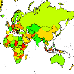
Biuro Geografa Stanów Zjednoczonych udostępnia zbiór danych Large Scale International Boundary (LSIB). Pochodzi on z 2 innych zbiorów danych: pliku wektorowego LSIB i World Vector Shorelines (WVS) z National Geospatial-Intelligence Agency (NGA). Granice wewnętrzne odzwierciedlają politykę rządu USA w zakresie granic, sporów granicznych i suwerenności. Granice zewnętrzne pochodzą z WVS, ale dane o linii brzegowej WVS są nieaktualne i zwykle przesunięte o kilkaset metrów lub ponad kilometr. Każdy obiekt to obszar wielokątny ograniczony wewnętrznymi granicami i zewnętrznymi liniami brzegowymi (w stosownych przypadkach), a wiele krajów składa się z wielu obiektów, po jednym na każdy rozłączny region. Każda z 180 741 cech jest częścią geometrii jednego z 284 krajów opisanych w tym zbiorze danych.
Schemat tabeli
Schemat tabeli
| Nazwa | Typ | Opis |
|---|---|---|
| OBJECTID | CIĄG ZNAKÓW | Identyfikator obiektu |
| COUNTRY_NA | CIĄG ZNAKÓW | Nazwa kraju uznawana w Stanach Zjednoczonych |
Warunki korzystania z usługi
Warunki usługi
Nie ma ograniczeń dotyczących korzystania z tych danych z domeny publicznej w Stanach Zjednoczonych.
Odkrywaj za pomocą Earth Engine
Edytor kodu (JavaScript)
var dataset = ee.FeatureCollection('USDOS/LSIB/2017');
var styleParams = {
  fillColor: 'b5ffb4',
  color: '00909F',
  width: 3,
};
var countries = dataset.style(styleParams);
Map.setCenter(16.35, 48.83, 4);
Map.addLayer(countries, {}, 'USDOS/LSIB/2017', true, 0.8);
Wyświetlanie jako widok cech
FeatureView to przyspieszona reprezentacja FeatureCollection, którą można tylko wyświetlać. Więcej informacji znajdziesz w
FeatureView dokumentacji.
Edytor kodu (JavaScript)
var fvLayer = ui.Map.FeatureViewLayer('USDOS/LSIB/2017_FeatureView');

var visParams = {
  color: '00909F',
  fillColor: 'b5ffb4',
  width: 3,
  opacity: 1
};

fvLayer.setVisParams(visParams);
fvLayer.setName('USDOS/LSIB/2017');

Map.setCenter(16.35, 48.83, 4);
Map.add(fvLayer);