- Dostępność zbioru danych
- 2017-03-30T00:00:00Z–2017-03-30T00:00:00Z
- Dostawca zbioru danych
- United States Department of State, Office of the Geographer
- Tagi
Opis
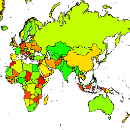
Biuro Geografa Stanów Zjednoczonych udostępnia zbiór danych Large Scale International Boundary (LSIB). Szczegółowa wersja (2013) pochodzi z 2 innych zbiorów danych: pliku wektorowego linii LSIB i zbioru World Vector Shorelines (WVS) z National Geospatial-Intelligence Agency (NGA). Wewnętrzne granice odzwierciedlają politykę rządu USA w zakresie granic, sporów granicznych i suwerenności. Zewnętrzne granice pochodzą z WVS, ale dane o linii brzegowej WVS są nieaktualne i zwykle przesunięte o kilkaset metrów lub nawet ponad kilometr. Każdy obiekt to obszar wielokątny ograniczony wewnętrznymi granicami i zewnętrznymi liniami brzegowymi (w stosownych przypadkach). Wiele krajów składa się z kilku obiektów, po jednym na każdy rozłączny region.
W porównaniu ze szczegółowym LSIB w tym uproszczonym zbiorze danych niektóre rozłączone regiony każdego kraju zostały zredukowane do jednej cechy. Nie obejmuje też średnich i mniejszych wysp. Uproszczone linie graniczne rzadko są przesunięte o więcej niż 100 metrów od szczegółowych linii LSIB. Każda z 312 cech jest częścią geometrii jednego z 284 krajów opisanych w tym zbiorze danych.
Schemat tabeli
Schemat tabeli
| Nazwa | Typ | Opis |
|---|---|---|
| abbreviati | CIĄG ZNAKÓW | Skrót nazwy kraju |
| country_co | CIĄG ZNAKÓW | |
| country_na | CIĄG ZNAKÓW | Nazwa kraju uznawana w Stanach Zjednoczonych |
| wld_rgn | CIĄG ZNAKÓW | Region kontynentalny, np. Ameryka Południowa |
Warunki korzystania z usługi
Warunki korzystania z usługi
Nie ma ograniczeń dotyczących korzystania z tych danych z domeny publicznej w Stanach Zjednoczonych.
Odkrywaj za pomocą Earth Engine
Edytor kodu (JavaScript)
var dataset = ee.FeatureCollection('USDOS/LSIB_SIMPLE/2017');
var styleParams = {
  fillColor: 'b5ffb4',
  color: '00909F',
  width: 3,
};
var countries = dataset.style(styleParams);
Map.setCenter(16.35, 48.83, 4);
Map.addLayer(countries, {}, 'USDOS/LSIB_SIMPLE/2017', true, 0.8);
import ee
import geemap.core as geemap
Colab (Python)
dataset = ee.FeatureCollection('USDOS/LSIB_SIMPLE/2017')

countries = dataset.style(fillColor='b5ffb4', color='00909F', width=3)

m = geemap.Map()
m.set_center(16.35, 48.83, 4)
m.add_layer(countries, {}, 'USDOS/LSIB_SIMPLE/2017', True, 0.8)
m
Wyświetlanie jako widok cech
FeatureView to przyspieszona reprezentacja FeatureCollection, którą można tylko wyświetlać. Więcej informacji znajdziesz w
dokumentacji.FeatureView
Edytor kodu (JavaScript)
var fvLayer = ui.Map.FeatureViewLayer('USDOS/LSIB_SIMPLE/2017_FeatureView');

var visParams = {
  color: '00909F',
  fillColor: 'b5ffb4',
  width: 3,
  opacity: 1
};

fvLayer.setVisParams(visParams);
fvLayer.setName('USDOS/LSIB_SIMPLE/2017');

Map.setCenter(16.35, 48.83, 4);
Map.add(fvLayer);
import ee
import geemap.core as geemap
Colab (Python)
dataset = ee.FeatureCollection('USDOS/LSIB_SIMPLE/2017')

countries = dataset.style(fillColor='b5ffb4', color='00909F', width=3)

m = geemap.Map()
m.set_center(16.35, 48.83, 4)
m.add_layer(countries, {}, 'USDOS/LSIB_SIMPLE/2017', True, 0.8)
m