- مدى توفّر مجموعة البيانات
- 1924-01-01T00:00:00Z–2022-05-04T00:00:00Z
- الجهة المنتجة لمجموعة البيانات
- هيئة المسح الجيولوجي الأمريكية
- العلامات
الوصف
هذه هي مجموعة بيانات DEM السلسة الخاصة ببرنامج 3DEP في الولايات المتحدة، وهي تغطي جميع الولايات الـ 48 المتجاورة وهاواي والأراضي التابعة للولايات المتحدة. تتوفّر تغطية جزئية لألاسكا الآن، ويتم توسيعها لتشمل الولاية بأكملها في إطار "مبادرة رسم خرائط ألاسكا". وتبلغ المسافة بين النقاط على الأرض 10 أمتار تقريبًا في الاتجاه الشمالي/الجنوبي، ولكنها تختلف في الاتجاه الشرقي/الغربي بسبب تقارب خطوط الطول مع خط العرض.
يتم استيعاب مجموعة بيانات 1m بتنسيق USGS_3DEP_1m.
مجموعة البيانات التي حمّلتها Farmers Business Network
النطاقات
النطاقات
حجم البكسل: 10.2 متر (جميع النطاقات)
| الاسم | الوحدات | حجم البكسل | الوصف |
|---|---|---|---|
elevation |
م | 10.2 متر | الارتفاع |
بنود الاستخدام
بنود الاستخدام
معظم المعلومات التي تقدّمها هيئة المسح الجيولوجي الأمريكية (USGS) متاحة للجميع ويمكن استخدامها بدون قيود. تتوفّر معلومات إضافية حول الإشارة إلى مؤسسة USGS كمصدر للمعلومات أو تقديم الشكر لها.
الاقتباسات
مصلحة المساحة الجيولوجية في الولايات المتحدة، برنامج 3D Elevation Program، نموذج الارتفاع الرقمي بدقة 10 أمتار
الاستكشاف باستخدام Earth Engine
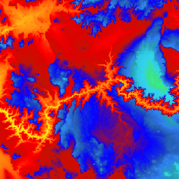
أداة تعديل الرموز (JavaScript)
var dataset = ee.ImageCollection('USGS/3DEP/10m_collection')
var elevation = dataset.select('elevation');

Map.setCenter(-112.8598, 36.2841, 7);
Map.addLayer(elevation, {min: 0, max: 3000,   palette: [
    '3ae237', 'b5e22e', 'd6e21f', 'fff705', 'ffd611', 'ffb613', 'ff8b13',
    'ff6e08', 'ff500d', 'ff0000', 'de0101', 'c21301', '0602ff', '235cb1',
    '307ef3', '269db1', '30c8e2', '32d3ef', '3be285', '3ff38f', '86e26f'
  ],
}, 'elevation');