- 데이터 세트 제공
- 2001-01-01T00:00:00Z–2002-01-01T00:00:00Z
- 데이터 세트 출처
- USGS
- 태그
설명
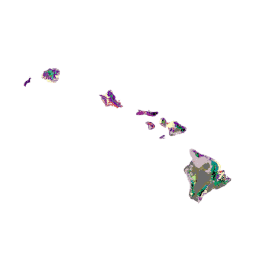
GAP/LANDFIRE National Terrestrial Ecosystems 데이터는 미국 본토의 상세한 식생 및 토지 피복 분류를 나타냅니다. 알래스카, 하와이, 푸에르토리코. GAP/LF 2011 미국 본토 생태계는 National Gap Analysis Program Land Cover Data - Version 2.2의 업데이트입니다. 알래스카 생태계는 LANDFIRE에 의해 2012년 조건 (LANDFIRE 2012)으로 업데이트되었습니다. 하와이 및 푸에르토리코 데이터는 2001년 기간을 나타냅니다 (Gon et al. 2006, Gould et al. 2008). 알래스카와 미국 본토 48개 주에 사용된 분류 체계는 NatureServe의 생태계 분류 (Comer et al. 2003)를 기반으로 하며, 푸에르토리코와 하와이의 지도 범례는 섬별 분류 체계 (Gon et al. 2006, Gould et al. 2008)를 기반으로 합니다.
대역
대역
픽셀 크기: 30미터 (모든 밴드)
| 이름 | 최소 | 최대 | 픽셀 크기 | 설명 |
|---|---|---|---|---|
landcover |
1 | 9 | 30m | 토지 피복 클래스 설명 |
토지 피복 클래스 표
| 값 | 색상 | 설명 |
|---|---|---|
| 1 | #7c009c | 혼합 토착-외래종 숲 |
| 2 | #c14f00 | 혼합(토종 및 외래 관목과 풀) |
| 3 | #c1e09e | 토종 해안 식물 |
| 4 | #ef0047 | 데샴시아 초원 |
| 5 | #d67900 | Aalii Shrubland |
| 6 | #00e3eb | 습지 식물 |
| 7 | #ccbf70 | 토착 건조 절벽 식물 |
| 8 | #7c7047 | 기본 관목지 / 드문 오히아 (기본 관목) |
| 9 | #617000 | 토종 습지 절벽 식물 |
| 10 | #66e805 | Open Mao Shrubland |
| 11 | #bf6b00 | Uluhe Shrubland |
| 12 | #9bcc9b | Closed Hala Forest |
| 13 | #008f99 | 폐쇄된 코아-오히아 숲 |
| 14 | #009c61 | Closed Ohia Forest(폐쇄된 오히아 숲) |
| 15 | #2bcf56 | 폐쇄된 Pouteria Forest (자생 나무) |
| 16 | #3ff2bf | Koa Forest |
| 17 | #9b9b4c | 마마네 / 나이오 / 토종 나무 |
| 18 | #8ebc00 | 원생 중습성~건조성 숲 및 관목지 |
| 19 | #33c7a6 | 토종 습윤 숲과 관목지 |
| 20 | #7fbf00 | 오히아 숲 |
| 21 | #007f7f | Olopua-Lama Forest |
| 22 | #b3ed7f | Open Koa-Mamane Forest |
| 23 | #21ab33 | Koa-Ohia Forest 열기 |
| 24 | #000000 | Open Ohia Forest |
| 25 | #002dc2 | 바다 수영 |
| 26 | #afe200 | 습지 식생 |
| 27 | #fefec1 | 농업 |
| 28 | #eb3642 | 고강도 개발 |
| 29 | #c94d42 | 낮은 강도 개발 |
| 30 | #ccb8bf | 외계 초원 |
| 31 | #9f298c | 외계인 관목지 |
| 32 | #75009c | 외계인 숲 |
| 33 | #460075 | Kiawe Forest and Shrubland |
| 34 | #001493 | 특성이 지정되지 않은 포레스트 |
| 35 | #ededed | 특성이 지정되지 않은 개방형 희박한 식생 |
| 36 | #d99485 | 특성이 지정되지 않은 관목지 |
| 37 | #6b6b6b | 식생이 매우 희소함 ~ 식생 없음 |
이용약관
이용약관
대부분의 미국 지질조사국 (USGS) 정보는 공개 도메인에 속하며 제한 없이 사용할 수 있습니다. 정보 소스로 USGS를 인정하거나 출처를 표시하는 방법에 관한 추가 정보도 제공됩니다.
인용
Gon, S.M., A. Allison, R. J. Cannarella, J. D. Jacobi, K. Y. Kaneshiro, M. H. Kido, M. Lane-Kamehele, S. E. 밀러 2006. The Hawaii Gap Analysis Project Final Report. 487쪽
Earth Engine으로 탐색
코드 편집기(JavaScript)
var dataset = ee.Image('USGS/GAP/HI/2001');

var visualization = {
  bands: ['landcover'],
  min: 1.0,
  max: 37.0,
};

Map.setCenter(-157.0, 20.1, 7);

Map.addLayer(dataset, visualization, 'GAP Hawaii');