-
LANDFIRE BPS (생물리학적 설정) v1.4.0

LANDFIRE (LF), 즉 Landscape Fire and Resource Management Planning Tools는 미국 농무부 산림청, 미국 내무부 지질조사국, 네이처 컨서번시의 야생지 화재 관리 프로그램 간에 공유되는 프로그램입니다. LANDFIRE (LF) 레이어는 예측 … doi fire forest-biomass landfire nature-conservancy usda -
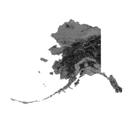
LANDFIRE ESP AK (환경 부지 잠재력) v1.2.0

LANDFIRE (LF), 즉 Landscape Fire and Resource Management Planning Tools는 미국 농무부 산림청, 미국 내무부 지질조사국, 네이처 컨서번시의 야생지 화재 관리 프로그램 간에 공유되는 프로그램입니다. LANDFIRE (LF) 레이어는 예측 … doi fire forest-biomass landfire nature-conservancy usda -
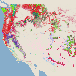
LANDFIRE ESP CONUS (환경 부지 잠재력) v1.2.0

LANDFIRE (LF), 즉 Landscape Fire and Resource Management Planning Tools는 미국 농무부 산림청, 미국 내무부 지질조사국, 네이처 컨서번시의 야생지 화재 관리 프로그램 간에 공유되는 프로그램입니다. LANDFIRE (LF) 레이어는 예측 … doi fire forest-biomass landfire nature-conservancy usda -
LANDFIRE ESP HI (환경 부지 잠재력) v1.2.0

LANDFIRE (LF), 즉 Landscape Fire and Resource Management Planning Tools는 미국 농무부 산림청, 미국 내무부 지질조사국, 네이처 컨서번시의 야생지 화재 관리 프로그램 간에 공유되는 프로그램입니다. LANDFIRE (LF) 레이어는 예측 … doi fire forest-biomass landfire nature-conservancy usda -
LANDFIRE EVC (기존 식생 피복) v1.4.0

LANDFIRE (LF), 즉 Landscape Fire and Resource Management Planning Tools는 미국 농무부 산림청, 미국 내무부 지질조사국, 네이처 컨서번시의 야생지 화재 관리 프로그램 간에 공유되는 프로그램입니다. LANDFIRE (LF) 레이어는 예측 … doi fire forest-biomass landfire nature-conservancy usda -
LANDFIRE EVH (기존 식물 높이) v1.4.0

LANDFIRE (LF), 즉 Landscape Fire and Resource Management Planning Tools는 미국 농무부 산림청, 미국 내무부 지질조사국, 네이처 컨서번시의 야생지 화재 관리 프로그램 간에 공유되는 프로그램입니다. LANDFIRE (LF) 레이어는 예측 … doi fire forest-biomass landfire nature-conservancy usda -
LANDFIRE EVT (기존 식생 유형) v1.4.0

LANDFIRE (LF), 즉 Landscape Fire and Resource Management Planning Tools는 미국 농무부 산림청, 미국 내무부 지질조사국, 네이처 컨서번시의 야생지 화재 관리 프로그램 간에 공유되는 프로그램입니다. LANDFIRE (LF) 레이어는 예측 … doi fire forest-biomass landfire nature-conservancy usda -
LANDFIRE FRG (화재 체제 그룹) v1.2.0

LANDFIRE (LF), Landscape Fire and Resource Management Planning Tools는 미국 농무부 산림청, 미국 내무부 지질조사국, 네이처 컨서번시의 야생지 화재 관리 프로그램 간에 공유되는 프로그램입니다. Landfire (LF) 역사적 화재 체제, 간격, … doi fire landfire nature-conservancy usda usgs -
LANDFIRE MFRI (평균 화재 재발 간격) v1.2.0

LANDFIRE (LF), Landscape Fire and Resource Management Planning Tools는 미국 농무부 산림청, 미국 내무부 지질조사국, 네이처 컨서번시의 야생지 화재 관리 프로그램 간에 공유되는 프로그램입니다. Landfire (LF) 역사적 화재 체제, 간격, … doi fire landfire nature-conservancy usda usgs -
LANDFIRE PLS (낮은 심각도 화재 비율) v1.2.0

LANDFIRE (LF), Landscape Fire and Resource Management Planning Tools는 미국 농무부 산림청, 미국 내무부 지질조사국, 네이처 컨서번시의 야생지 화재 관리 프로그램 간에 공유되는 프로그램입니다. Landfire (LF) 역사적 화재 체제, 간격, … doi fire landfire nature-conservancy usda usgs -
LANDFIRE PMS (혼합 심각도 화재 비율) v1.2.0

LANDFIRE (LF), Landscape Fire and Resource Management Planning Tools는 미국 농무부 산림청, 미국 내무부 지질조사국, 네이처 컨서번시의 야생지 화재 관리 프로그램 간에 공유되는 프로그램입니다. Landfire (LF) 역사적 화재 체제, 간격, … doi fire landfire nature-conservancy usda usgs -
LANDFIRE PRS (교체 심각도 화재 비율) v1.2.0

LANDFIRE (LF), Landscape Fire and Resource Management Planning Tools는 미국 농무부 산림청, 미국 내무부 지질조사국, 네이처 컨서번시의 야생지 화재 관리 프로그램 간에 공유되는 프로그램입니다. Landfire (LF) 역사적 화재 체제, 간격, … doi fire landfire nature-conservancy usda usgs -
LANDFIRE SClass (계승 클래스) v1.4.0

LANDFIRE (LF), Landscape Fire and Resource Management Planning Tools는 미국 농무부 산림청, 미국 내무부 지질조사국, 네이처 컨서번시의 야생지 화재 관리 프로그램 간에 공유되는 프로그램입니다. Landfire (LF) 역사적 화재 체제, 간격, … doi fire landfire nature-conservancy usda usgs -
LANDFIRE VCC (식물 상태 등급) v1.4.0

LANDFIRE (LF), Landscape Fire and Resource Management Planning Tools는 미국 농무부 산림청, 미국 내무부 지질조사국, 네이처 컨서번시의 야생지 화재 관리 프로그램 간에 공유되는 프로그램입니다. Landfire (LF) 역사적 화재 체제, 간격, … doi fire landfire nature-conservancy usda usgs -
LANDFIRE VDep (Vegetation Departure) v1.4.0

LANDFIRE (LF), Landscape Fire and Resource Management Planning Tools는 미국 농무부 산림청, 미국 내무부 지질조사국, 네이처 컨서번시의 야생지 화재 관리 프로그램 간에 공유되는 프로그램입니다. Landfire (LF) 역사적 화재 체제, 간격, … doi fire landfire nature-conservancy usda usgs -
USFS TreeMap v2016 (미국 본토)

이 제품은 트리맵 데이터 모음의 일부입니다. 2016년 미국 본토의 전체 산림 범위에 걸쳐 살아 있는 나무와 죽은 나무의 수, 바이오매스, 탄소를 비롯한 산림 특성에 관한 자세한 공간 정보를 제공합니다. 트리맵 v2016에는 하나의 이미지가 포함되어 있습니다. biomass carbon climate-change conus forest forest-biomass -
USFS TreeMap v2020

이 제품은 TreeMap 데이터 제품군의 일부입니다. 2020년 미국 전체 산림 지역의 생존 및 고사 나무 수, 바이오매스, 탄소 등 산림 특성에 관한 자세한 공간 정보를 제공합니다. TreeMap v2020에는 22개 밴드 30x30m … aboveground biomass carbon climate-change conus forest -
USFS TreeMap v2022
이 제품은 TreeMap 데이터 제품군의 일부입니다. 2022년 미국 전체 산림 지역의 생존 및 고사 나무 수, 바이오매스, 탄소 등 산림 특성에 관한 자세한 공간 정보를 제공합니다. TreeMap v2022에는 22개 밴드, 30x30m … aboveground biomass carbon climate-change conus forest -
USGS GAP Alaska 2001
GAP/LANDFIRE National Terrestrial Ecosystems 데이터는 미국 본토의 상세한 식생 및 토지 피복 분류를 나타냅니다. 알래스카, 하와이, 푸에르토리코.GAP/LF 2011 Ecosystems for the Conterminous U.S. 는 National Gap Analysis Program Land Cover Data - Version 2.2의 업데이트입니다. 알래스카 생태계 gap landcover landfire usgs vegetation -
USGS GAP CONUS 2011
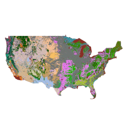
GAP/LANDFIRE National Terrestrial Ecosystems 데이터는 미국 본토의 상세한 식생 및 토지 피복 분류를 나타냅니다. 알래스카, 하와이, 푸에르토리코.GAP/LF 2011 Ecosystems for the Conterminous U.S. 는 National Gap Analysis Program Land Cover Data - Version 2.2의 업데이트입니다. 알래스카 생태계 gap landcover landfire usgs vegetation -
USGS GAP Hawaii 2001
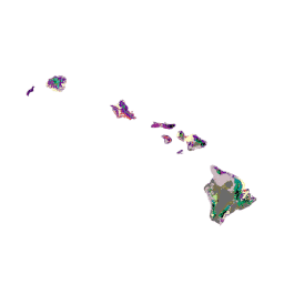
GAP/LANDFIRE National Terrestrial Ecosystems 데이터는 미국 본토의 상세한 식생 및 토지 피복 분류를 나타냅니다. 알래스카, 하와이, 푸에르토리코.GAP/LF 2011 Ecosystems for the Conterminous U.S. 는 National Gap Analysis Program Land Cover Data - Version 2.2의 업데이트입니다. 알래스카 생태계 gap landcover landfire usgs vegetation -
USGS GAP 푸에르토리코 2001
GAP/LANDFIRE National Terrestrial Ecosystems 데이터는 미국 본토의 상세한 식생 및 토지 피복 분류를 나타냅니다. 알래스카, 하와이, 푸에르토리코.GAP/LF 2011 Ecosystems for the Conterminous U.S. 는 National Gap Analysis Program Land Cover Data - Version 2.2의 업데이트입니다. 알래스카 생태계 gap landcover landfire usgs vegetation
Datasets tagged landfire in Earth Engine
[null,null,[],[],[]]