-
IPCC 지상 바이오매스 1단계 추정치에 대한 전 세계 2020년 산림 분류, V1

이 데이터 세트는 2020년의 상태/조건별로 구분된 전 세계 산림 클래스를 약 30m 해상도로 제공합니다. 이 데이터는 2006년 IPCC 국가 온실가스 인벤토리 작성 지침의 2019년 개선사항에 따라 천연림의 지상 건조 목재 바이오매스 밀도 (AGBD)에 대한 1단계 추정치를 생성하는 데 도움이 됩니다. 지상 바이오매스 탄소 분류 산림 산림 바이오매스 -
전 세계 지상 및 지하 바이오매스 탄소 밀도 지도

이 데이터 세트는 2010년의 지상 및 지하 바이오매스 탄소 밀도에 대한 시간적으로 일관되고 조화된 전 세계 지도를 300m 공간 해상도로 제공합니다. 지상 바이오매스 지도는 목재, 초지, 농지, 툰드라 바이오매스의 토지 피복별 원격 감지 지도를 통합합니다. 입력 지도는 … 지상 바이오매스 탄소 밀도 산림 산림 바이오매스 -
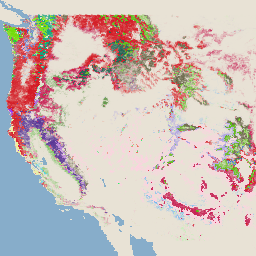
USFS TreeMap v2020

이 제품은 TreeMap 데이터 모음의 일부입니다. 2020년 미국 전역의 산림 지역에 걸쳐 살아있는 나무와 죽은 나무의 수, 바이오매스, 탄소를 비롯한 산림 특성에 관한 자세한 공간 정보를 제공합니다. TreeMap v2020에는 22개 대역 30x30m … 지상 바이오매스 탄소 기후 변화 conus 산림 -
USFS TreeMap v2022
이 제품은 TreeMap 데이터 모음의 일부입니다. 2022년 미국 전역의 산림 지역에 걸쳐 살아있는 나무와 죽은 나무의 수, 바이오매스, 탄소를 비롯한 산림 특성에 관한 자세한 공간 정보를 제공합니다. TreeMap v2022에는 22개 대역 30x30m … 지상 바이오매스 탄소 기후 변화 conus 산림 -
WHRC 범열대 국가 수준 탄소 저장량 데이터 세트

500m의 열대 국가에 대한 지상 살아있는 목재 바이오매스 밀도의 국가 수준 지도입니다. 이 데이터 세트는 공동 위치 현장 측정, LiDAR 관측, 중간 해상도 영상 분광계 (MODIS)에서 기록된 이미지를 조합하여 구성되었습니다. 지상 바이오매스 탄소 산림 바이오매스 지구 물리학 umd
Datasets tagged aboveground in Earth Engine
[null,null,[],[],[]]