-
GLCF: Landsat Global Inland Water
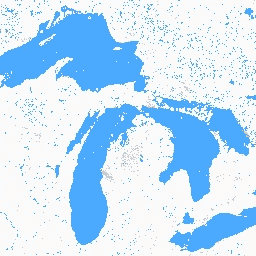
글로벌 내륙 수역 데이터 세트에는 담수호, 염수호, 강, 저수지 등 내륙 표면 수역이 표시됩니다. GLS 2000 에포크에서 3,650,723km2의 내륙수가 확인되었으며, 이 중 약 4분의 3이 북미와 아시아에 있었습니다. 북방림과 툰드라 … glcf landsat-derived nasa surface-ground-water umd water -
Global Forest Cover Change (GFCC) 산림 비율 다년도 전 세계 30m
Landsat Vegetation Continuous Fields (VCF) 트리 캐노피층에는 높이가 5m를 초과하는 목본 식물로 덮인 각 30m 픽셀의 수평 지면 비율 추정치가 포함되어 있습니다. 이 데이터 세트는 2000년, 2005년, 2010년 등을 중심으로 4개의 에포크에 사용할 수 있습니다. forest forest-biomass glcf landsat-derived nasa umd -
Hansen Global Forest Change v1.13 (2000~2025년)

전 세계 산림 범위와 변화를 특징짓는 Landsat 이미지의 시계열 분석 결과입니다. 'first' 및 'last' 밴드는 빨간색, NIR, SWIR1, SWIR2에 해당하는 Landsat 스펙트럼 밴드의 첫 번째 및 마지막 사용 가능한 연도의 참조 다중 스펙트럼 이미지입니다. 참조 합성 이미지는 다음을 나타냅니다. forest forest-biomass geophysical landsat-derived umd -
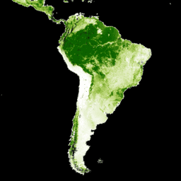
일차 습윤 열대 우림
1차 습윤 열대 우림은 수많은 글로벌 생태계 서비스를 제공하지만 경제적 동인으로 인한 벌채의 위협이 계속되고 있습니다. 국토 이용 계획을 촉진하고 경제 발전과 생태계 서비스 유지라는 목표의 균형을 맞추기 위해 1차 습윤 열대 우림 지도가 생성되었습니다. forest forest-biomass global landsat-derived umd -
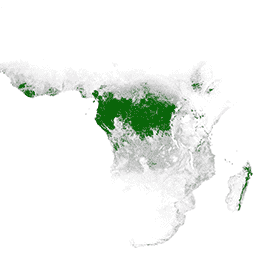
WHRC 범열대 국가 수준 탄소 저장량 데이터 세트

500m 해상도의 열대 국가 지상 활성 목재 바이오매스 밀도 국가 수준 지도입니다. 이 데이터 세트는 동일한 위치에서 측정한 현장 측정값, LiDAR 관측값, 중간 해상도 이미징 분광계 (MODIS)에서 기록한 이미지를 조합하여 구성되었습니다. aboveground biomass carbon forest-biomass geophysical umd
Datasets tagged umd in Earth Engine
[null,null,[],[],[]]